Tishomingo County is a county located in the northeastern corner of the U.S. state of Mississippi. As of the 2020 census, the population was 18,850. Its county seat is Iuka.

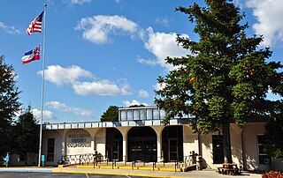
Aberdeen is the county seat of Monroe County, Mississippi, United States. As of the 2010 census, the population was 5,612.

The Tennessee River is the largest tributary of the Ohio River. It is approximately 652 miles (1,049 km) long and is located in the southeastern United States in the Tennessee Valley. The river was once popularly known as the Cherokee River, among other names, as the Cherokee people had their homelands along its banks, especially in what are now East Tennessee and northern Alabama. Additionally, its tributary, the Little Tennessee River, flows into it from Western North Carolina and northeastern Georgia, where the river also was bordered by numerous Cherokee towns. Its current name is derived from the Cherokee town, Tanasi, which was located on the Tennessee side of the Appalachian Mountains.

The Tombigbee River is a tributary of the Mobile River, approximately 200 mi (325 km) long, in the U.S. states of Mississippi and Alabama. Together with the Alabama, it merges to form the short Mobile River before the latter empties into Mobile Bay on the Gulf of Mexico. The Tombigbee watershed encompasses much of the rural coastal plain of western Alabama and northeastern Mississippi, flowing generally southward. The river provides one of the principal routes of commercial navigation in the southern United States, as it is navigable along much of its length through locks and connected in its upper reaches to the Tennessee River via the Tennessee-Tombigbee Waterway.
The Black Warrior River is a waterway in west-central Alabama in the southeastern United States. The river rises in the extreme southern edges of the Appalachian Highlands and flows 178 miles (286 km) to the Tombigbee River, of which the Black Warrior is the primary tributary. The river is named after the Mississippian paramount chief Tuskaloosa, whose name was Muskogean for 'Black Warrior'. The Black Warrior is impounded along nearly its entire course by a series of locks and dams to form a chain of reservoirs that not only provide a path for an inland waterway, but also yield hydroelectric power, drinking water, and industrial water.

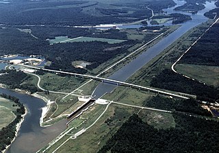
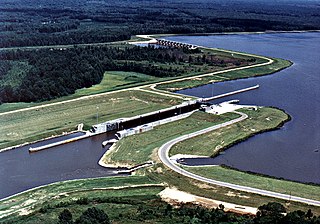
The Tennessee–Tombigbee Waterway is a 234-mile (377 km) artificial U.S. waterway built in the 20th century from the Tennessee River to the junction of the Black Warrior-Tombigbee River system near Demopolis, Alabama. The Tennessee–Tombigbee Waterway links commercial navigation from the nation's midsection to the Gulf of Mexico. The major features of the waterway are 234 miles (377 km) of navigation channels, a 175-foot-deep (53 m) cut between the watersheds of the Tombigbee and Tennessee rivers, and ten locks and dams. The locks are 9 by 110 by 600 feet, the same dimension as those on the Mississippi above Lock and Dam 26 at Alton, Illinois. Under construction for 12 years by the U.S. Army Corps of Engineers, the Tennessee–Tombigbee Waterway was completed in December 1984 at a total cost of nearly $2 billion.
Columbus Lake is a lake in northeast Mississippi on the Tennessee-Tombigbee Waterway. Close to Columbus, it is impounded by the John C. Stennis Lock and Dam.
Aberdeen Lake is a lake in northeast Mississippi on the Tennessee-Tombigbee Waterway. Close to Aberdeen, it is impounded by the Aberdeen Lock and Dam.

The John C. Stennis Lock and Dam, formerly named Columbus Lock and Dam, is one of four lock and dam structures on the Tennessee-Tombigbee Waterway that generally lie along the original course of the Tombigbee River. It is located near Columbus, Mississippi, and impounds Columbus Lake. It is named for longtime U.S. Senator from Mississippi, John C. Stennis.

The Tom Bevill Lock and Dam, formerly named Aliceville Lock and Dam and "Memphis Lock and Dam", is one of four lock and dam structures on the Tennessee-Tombigbee Waterway that generally lie along the original course of the Tombigbee River. It is located near Aliceville, Alabama and impounds Aliceville Lake. It is named for Tom Bevill, a proponent of the Tenn-Tom.
The Howell Heflin Lock and Dam, formerly Gainesville Lock and Dam, is one of four lock and dam structures on the Tennessee-Tombigbee Waterway that generally lie along the original course of the Tombigbee River. It is located near Gainesville, Alabama, and impounds Gainesville Lake. It is named for Howell Heflin, a former United States Senator from Alabama.
Aliceville Lake is a reservoir in western Alabama and eastern Mississippi, on the Tennessee-Tombigbee Waterway. Close to Aliceville, it is impounded by the Tom Bevill Lock and Dam.
Gainesville Lake is a reservoir in northwest Alabama on the Tennessee-Tombigbee Waterway. Close to Gainesville, it is impounded by the Howell Heflin Lock and Dam.

The Amory Lock is a lock and dam on the Tennessee-Tombigbee Waterway.
The Glover Wilkins Lock is a lock of the Tennessee-Tombigbee Waterway. It is located close to Smithville, Mississippi. It was named for Glover Wilkins.

The Fulton Lock is a lock and dam on the Tennessee-Tombigbee Waterway.

The Jamie Whitten Lock and Dam is part of the Tennessee-Tombigbee Waterway. It is located in south Tishomingo County, Mississippi, United States, close to the Prentiss County line.
Plymouth was an early settlement in Mississippi in present-day Lowndes County. Plymouth was located at 33°31′23″N88°30′06″W on the west bank of the Tombigbee River. It was formed around 1819, developing around the fortified house of John Pitchlynn, the U.S. interpreter for the Choctaw Agency. The low-lying site of the village was prone to repeated flooding. While both Plymouth and its sister town of Columbus across the river had high bluffs, Plymouth's landing site did not have easy access to the bluff heights. By the 1840s, the village site was abandoned, as most of the residents had moved across the river to the better site of Columbus.
Bay Springs Lake is a reservoir on the Tennessee-Tombigbee Waterway in the U.S. state of Mississippi. It is impounded by the Jamie Whitten Lock and Dam. The lake is approximately nine miles long, between waterway mile markers 412 at the dam, and 421 near the entrance to the divide cut.

The Great Loop is a system of waterways that encompasses the eastern portion of the United States and part of Canada. It is made up of both natural and man-made waterways, including the Atlantic and Gulf Intracoastal Waterways, the Great Lakes, the Rideau Canal, and the Mississippi and Tennessee-Tombigbee Waterway. The entire loop stretches about 6,000 miles (9,700 km).
