This article may need to be rewritten to comply with Wikipedia's quality standards.(August 2018) |
Ampandoantraka is a city in Anosibe An'ala District, Alaotra-Mangoro Region, Madagascar with a population of 10.669 inhabitants [1]
This article may need to be rewritten to comply with Wikipedia's quality standards.(August 2018) |
Ampandoantraka is a city in Anosibe An'ala District, Alaotra-Mangoro Region, Madagascar with a population of 10.669 inhabitants [1]

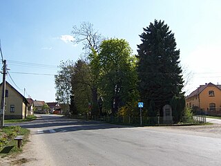
Žalobín is a village and municipality in Vranov nad Topľou District in the Prešov Region of eastern Slovakia.
German submarine U-759 was a Type VIIC U-boat of Nazi Germany's Kriegsmarine during World War II. The submarine was laid down on 15 November 1940 at the Kriegsmarinewerft yard at Wilhelmshaven, launched on 30 May 1942, and commissioned on 15 August 1942 under the command of Kapitänleutnant Rudolf Friedrich.

Barrington River, a perennial river of the Manning River catchment, is located in the Upper Hunter district of New South Wales, Australia.
Olmillos de Castro is a municipality located in the province of Zamora, Castile and León, Spain. According to the 2004 census (INE), the municipality has a population of 378 inhabitants.

Mosorolava or Misorolava is a municipality in Madagascar. It belongs to the district of Antsiranana II, which is a part of Diana Region. According to 2001 census the population of Mosorolava was 7,362.
Berevo is a town and commune in Madagascar. It belongs to the district of Belo sur Tsiribihina, which is a part of Menabe Region. The population of the commune was estimated to be approximately 3,000 in 2001 commune census.

Bölcske is a village in Tolna County, Hungary.
Alarobia is a town and commune in Madagascar. It belongs to the district of Manjakandriana, which is a part of Analamanga Region. The population of the commune was estimated to be approximately 16,000 in 2001 commune census.

Merghindeal is a commune located in Sibiu County, Romania. It is composed of two villages, Dealu Frumos and Merghindeal. Each of these has a fortified church.
Olkowice is a village in the administrative district of Gmina Promna, within Białobrzegi County, Masovian Voivodeship, in east-central Poland.

Tarnówka is a village in the administrative district of Gmina Tarczyn, within Piaseczno County, Masovian Voivodeship, in east-central Poland. It lies approximately 8 kilometres (5 mi) west of Tarczyn, 23 km (14 mi) south-west of Piaseczno, and 34 km (21 mi) south-west of Warsaw.
Zgliniec is a village in the administrative district of Gmina Krzywiń, within Kościan County, Greater Poland Voivodeship, in west-central Poland. It lies approximately 6 kilometres (4 mi) west of Krzywiń, 15 km (9 mi) south-east of Kościan, and 50 km (31 mi) south of the regional capital Poznań.
Szczepankowo is a village in the administrative district of Gmina Dźwierzuty, within Szczytno County, Warmian-Masurian Voivodeship, in northern Poland. It lies approximately 3 kilometres (2 mi) north-east of Dźwierzuty, 19 km (12 mi) north of Szczytno, and 32 km (20 mi) east of the regional capital Olsztyn.
Svojetice is a village and municipality in Prague-East District in the Central Bohemian Region of the Czech Republic. The municipality covers an area of 2.57 km² and in 2009 it had a population of 656.
Ambalaomby is a city in Anosibe An'ala District, Alaotra-Mangoro Region, Madagascar.
Cerje is a village in the municipality of Bajina Bašta, Serbia. According to the 2002 census, the village had a population of 168.
Styggebrekka Crevasses is a crevasse field near the center of Austreskorve Glacier, in the Muhlig-Hofmann Mountains of Queen Maud Land. Plotted from surveys and air photos by Norwegian Antarctic Expedition (1956–60) and named Styggebrekka.
Gauss Glacier is a steep glacier on the north side of Datum Peak, descending west from the southwestern extremity of Hobbs Ridge into Blue Glacier, in Victoria Land, Antarctica. It was named by the New Zealand Geographic Board in 1993 after the German mathematician and astronomer Carl Friedrich Gauss.
The Bald Hill Creek, a watercourse that is part of the Barwon catchment of the Murray-Darling basin, is located in the Orana region of New South Wales, Australia.
Coordinates: 19°44′S47°58′E / 19.733°S 47.967°E
| This Alaotra-Mangoro location article is a stub. You can help Wikipedia by expanding it. |
