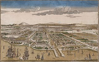
Amsterdam Gate, Jakarta

Last updated
Lithograph of the gate c.1881-1889 COLLECTIE TROPENMUSEUM De oude kasteelpoort van Batavia TMnr 3728-769.jpg
Lithograph of the gate c.1881–1889

The Amsterdam Gate (Dutch : Amsterdamse Poort) formed the entrance to the Castle Square (Dutch : Kasteelplein) south of Batavia Castle. The gate existed from 1744 up to the 1950s in what is now known as Kota, Jakarta, where it would have stood near the intersection of Jalan Nelayan Timur and Jalan Cengkeh.

Contents

History

Map of the Castle in 1762, showing the removed original wall (E) and the new gate (a, between I and H). The top is south. Kasteel Batavia 1762.jpg
Map of the Castle in 1762, showing the removed original wall (E) and the new gate (a, between I and H). The top is south.

Amsterdam Poort was first built in the 17th century. [1]

During the rule of governor-general Gustaaf Willen Baron van Imhoff between 1743 and 1750, the castle of Batavia was expanded. Among the involved works was the demolition of the fort's original southeast wall. A new southeast wall was built further south along the Amsterdamse Gracht (current day Nelayan Timur street), thereby including the Castle Square within the castle grounds. The newly build gate was changed to Rococo style. [1] The entrance through the new wall was formed by a gatehouse of two storeys high and topped with a dome and clock. Part of this building was used as a prison, in a similar fashion as the Gevangenpoort in The Hague. [2]

Owing to its location at the Amsterdamse Gracht, the gate was called the Amsterdamse Poort. Other names include Pinangpoort (English: Pinang Gate, after the trade in pinang that took place there) and Kasteelpoort (English: Castle Gate).

The gate surrounded by arcades. COLLECTIE TROPENMUSEUM De Amsterdamse Poort te Batavia TMnr 60004991.jpg
The gate surrounded by arcades.

In 1808, governor-general Daendels commissioned the relocation of the seat of government to Weltevreden. The construction works there were supplied partially by reusing building material from the Castle of Batavia. Most buildings on the castle grounds had been demolished, save for a part of the Amsterdam gate and connected arcades. The arched wing of the gate was connected to the building that formed part of the fort. [1]

When Daendels destroyed the castle, only this gate remained. In the 1840s, the gate was rebuilt with Mars and Minerva statues mounted on the left and right sides of the gates like a pair of guards. [1]

The gate was then reduced further to its final form, after the arcades were removed around 1870 in order to provide passage to a tramway. This gate existed until the 1950s, when the last remnants were removed.

In 2007, a replica of the gate was proposed as part of heritage conservation measures of Kota, Jakarta. [3]

Architecture

The gate around 1885 COLLECTIE TROPENMUSEUM De Amsterdamse Poort in Batavia met de beelden van Mars en Minerva. TMnr 60005479.jpg
The gate around 1885

The gate was originally part of a baroque gatehouse, large enough to accommodate a small prison. The gatehouse had two storeys and was covered by a dome with a cupola on top. Semi-circular arcades connected the gatehouse to two flanking military buildings. [2]

The remains of the gate after the demolitions of Daendels only counted one storey. The gateway had a rounded arch and was decorated with columns. On top of the gate were eight black urns. The south facade had two niches containing statues of Mars and of Minerva. These statues disappeared during the Japanese occupation in World War II.

See also

Related Research Articles

Bandung City and capital of West Java, Indonesia

Bandung is the capital city of the Indonesian province of West Java. It has a population of 2,444,160 within its city limits, making it the fourth most populous city in Indonesia. Greater Bandung is the country's third-largest metropolitan area, with over eight million inhabitants. Located 768 metres above sea level, the highest point in the North area with an altitude of 1,050 meters and the lowest in the South is 675 meters above sea level, approximately 140 kilometres southeast of Jakarta, Bandung has cooler year-round temperatures than most other Indonesian cities. The city lies on a river basin surrounded by volcanic mountains that provides a natural defence system, which was the primary reason for the Dutch East Indies government's plan to move the capital from Batavia to Bandung.

Batavia, Dutch East Indies Capital of the Dutch East Indies

Batavia, also called Batauia in the city's Malay vernacular, was the capital of the Dutch East Indies. The area corresponds to present-day Jakarta, Indonesia. Batavia can refer to the city proper or its suburbs and hinterland, the Ommelanden, which included the much-larger area of the Residency of Batavia in the present-day Indonesian provinces of Jakarta, Banten and West Java.

Menteng District in Special Capital City District of Jakarta, Indonesia

Menteng is the south-central district of Central Jakarta, one of the administrative municipalities in the capital city Jakarta, Indonesia.

Sawah Besar District in Special Capital City District of Jakarta, Indonesia

Sawah Besar is a district (kecamatan) of Central Jakarta, Indonesia. Its neighborhoods are among the most historic, containing the 1820-established Pasar Baru, the new colonial city – Weltevreden – and the old course of the Ciliwung river. Landmarks include the Lapangan Banteng, the government's 19th century-built, low-rise A.A. Maramis Building and its high palmed-lawned vista, and Jakarta Cathedral.

Jatinegara District in Special Capital City District of Jakarta, Indonesia

Jatinegara is one of the districts (Kecamatan) of East Jakarta, Indonesia. The name also refers to the larger, historic area of the colonial town of Meester Cornelis. Established in the 17th century, Jatinegara is one of the oldest areas in Jakarta, and contains a number of buildings from the colonial period.

Kota Tua Jakarta

Kota Tua Jakarta, officially known as Kota Tua, is a neighborhood comprising the original downtown area of Jakarta, Indonesia. It is also known as Oud Batavia, Benedenstad, or Kota Lama.

History of Jakarta Timeline of Jakartas history

Jakarta is Indonesia's capital and largest city. Located on an estuary of the Ciliwung River, on the northwestern part of Java, the area has long sustained human settlement. Historical evidence from Jakarta dates back to the 4th century CE, when it was a Hindu settlement and port. The city has been sequentially claimed by the Indianized kingdom of Tarumanegara, the Hindu Kingdom of Sunda, the Muslim Sultanate of Banten, and by Dutch, Japanese and Indonesian administrations. The Dutch East Indies built up the area before it was taken during World War II by the Empire of Japan and finally became independent as part of Indonesia.

Merdeka Square, Jakarta

Merdeka Square is a large square located in the center of Jakarta, Indonesia. Merdeka is the Indonesian word for freedom or independence. Measuring approximately one square kilometer in area, if the surrounding fields within the Merdeka Square are included, it is considered one of the largest squares in the world. At 75 hectares, it is over five times the size of Tiananmen Square, and 12 times the size of Place de la Concorde.

Capital of Indonesia National capital in Indonesia

The capital of the Republic of Indonesia is Jakarta, one of the oldest continuously inhabited cities in Southeast Asia. Previously known as Batavia, it was the de facto capital of the Dutch East Indies. In the early 20th century, the Dutch East Indies government attempted to relocate the capital from Batavia to Bandung. During Indonesia's struggle for independence, the Indonesian government moved the capital to Yogyakarta and then to Bukittinggi, where it remained for a short time until the restoration of control to Jakarta. In 2019, during his annual state of the union address at the parliament, President Joko Widodo announced a plan to relocate the capital to Kalimantan on the island of Borneo. As part of the plan, part of Kutai Kartanegara Regency and Penajam North Paser Regency in East Kalimantan will be carved out to create a new province-level planned city, and the capital will be relocated to a more central location within Indonesia. On 17 January 2022, the name was revealed to be Nusantara.

Colonial architecture in Jakarta

Colonial buildings and structures in Jakarta include those that were constructed during the Dutch colonial period of Indonesia. The period succeeded the earlier period when Jakarta, governed by the Sultanate of Banten, were completely eradicated and replaced with a walled city of Batavia. The dominant styles of the colonial period can be divided into three periods: the Dutch Golden Age, the transitional style period, and Dutch modernism. Dutch colonial architecture in Jakarta is apparent in buildings such as houses or villas, churches, civic buildings, and offices, mostly concentrated in the administrative city of Central Jakarta and West Jakarta.

The following is a timeline of the history of the city of Jakarta, Indonesia.
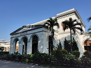
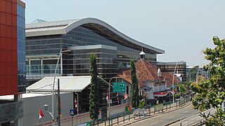
Lapangan Banteng

Lapangan Banteng is a historic square located in a historic area formerly known as Weltevreden, today Sawah Besar subdistrict, Central Jakarta, Indonesia.

Fatahillah Square

Fatahillah Square is the historical center of the old Batavia. The square is located at the center of Jakarta Old Town. Today the square is a tourist area home to the Jakarta History Museum, Wayang Museum and Fine Art and Ceramics Museum in Kota, Jakarta.

Harmony Society, Batavia

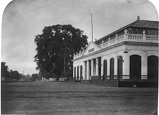
The Harmony Society was an elite social club in Batavia, Dutch East Indies. It was the oldest clubhouse in Asia when it was demolished. The construction of the group's building included the former bricks of the wall of Old Batavia. It was demolished for road widening and parking area in 1985. Activities at the club included cards and billiards. Indigenous people were excluded from the club.

Indies Empire style Architectural style in Dutch East Indies

Indies Empire style is an architectural style that flourished in the colonial Dutch East Indies between the middle of the 18th century and the end of the 19th century. The style is an imitation of neoclassical Empire Style which was popular in mid-19th-century France. Conformed to the tropical setting of Indonesia, the style became known in the Dutch East Indies as Indies Empire style.

A.A. Maramis Building Government building in Jakarta, Indonesia

The A.A. Maramis Building is an early 19th century building in Jakarta, Indonesia. It hosts the headquarters of the Indonesian Ministry of Finance.

Jalan Gajah Mada and Jalan Hayam Wuruk

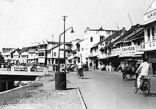
Jalan Gajah Mada and Jalan Hayam Wuruk, formerly Molenvliet West and Molenvliet Oost respectively, is a major thoroughfare located in Jakarta, Indonesia. The two streets with its canal, the Batang Hari, connected Glodok and Kota Tua Jakarta to the north with Harmoni Junction to the south. Completed in late 1640s, the canal-street Gajah Mada and Hayam Wuruk is Jakarta's oldest major thoroughfare.

Tanjung Barat

Tandjong West was a particuliere land or private domain in modern-day Tanjung Barat, Jagakarsa, South Jakarta, Indonesia. The center of the domain was the eponymous Landhuis Tandjong West, an eighteenth-century Dutch colonial manor house.

Baru Timur River

Baru Timur River is a man-made canal flowing from Ci Liwung in Bogor Regency to Jakarta, Indonesia. It was one of two canals built in the 18th century under the order of the Governor-General Gustaaf Willem van Imhoff originally to transport agriculture harvest from Bogor to Batavia. Currently both canals, now known as Kali Baru Timur and Kali Baru Barat, are among the main rivers in Jakarta, and part of the Ciliwung Cisadane flood control project. Baru Timur River flows from Katulampa flood gate, built at the same time as the canal, along the major road Bogor Highway, passing Cimanggis, Depok, Cilangkap, until reaching Java Sea in Kali Besar, Tanjung Priok, North Jakarta.

Prinsen Straat, or Prince Street in English, was one of the busiest main streets in Batavia, Dutch East Indies where business and trade took place. It is now called Jalan Cengkeh in Jakarta. Jalan Cengkeh is located in the main area surrounding Kota Tua.

References

  1. 1 2 3 4 "Dari Prinsen Straat ke Prinsen Park". Kompas. 23 January 2010. Retrieved 16 July 2018.
  2. 1 2 "Gezicht op de Amsterdamse poort vanuit het Zuiden | Atlas of Mutual Heritage".
  3. The Jakarta Post, retrieved 11 April 2010

Coordinates: 6°07′51″S106°48′43″E / 6.1308°S 106.8120°E / -6.1308; 106.8120