Amsterdam tram line 24

Last updated

Line 24 is a GVB run tram between the edge of the center of Amsterdam and the northwestern part of Buitenveldert. The starting and ending points are Frederiksplein and the Vrije Universiteit on De Boelelaan. [1]

Contents

Tramlijn 24 (Amsterdam)
Gvba24.png
De Boelelaan, eindhalte lijn 24 pic1.JPG
Overview
Locale Amsterdam
Termini
Stations15
Website GVB Lijn 24
Service
Route number24
Operator(s) Gemeente Vervoerbedrijf (GVB)
History
Opened17 October 1929
Technical
Line length6 Km
Number of tracks2
Track gauge 1,435 mm (4 ft 8+12 in)
Electrification 600 V DC overhead
Route map

BSicon uCONTg.svg
Lines 1, 7, 19
BSicon uSTR+l.svg
BSicon uABZg+r.svg
BSicon ulCONTf.svg
BSicon uSTR.svg
BSicon uBHF.svg
Frederiksplein
BSicon uCONTgq.svg
BSicon uABZg+r.svg
BSicon ulCONTg.svg
BSicon uSTR.svg
Line 4
BSicon uSTRl.svg
BSicon uSTR+r.svg
BSicon uKRZ.svg
BSicon uCONTfq.svg
Line 4
BSicon utSTR+r.svg
BSicon uBHF(R)f.svg
Frederiksplein
BSicon utBHF.svg
BSicon uHST.svg
Vijzelgracht metro 52
BSicon uCONTgq.svg
BSicon utSTR.svg
BSicon uSTRq.svg
BSicon uABZgr.svg
Lines 1, 7, 19
BSicon utSTR.svg
BSicon uHST.svg
Marie Heinekenplein
BSicon utSTR.svg
BSicon uABZg+l.svg
BSicon uCONTfq.svg
Lines 3, 12
BSicon utSTRl.svg
BSicon utSTRq.svg
BSicon uBHF.svg
De Pijp metro 52
BSicon uBHF(R)f.svg
Roelof Hartplein
BSicon uCONTgq.svg
BSicon uABZgr+r.svg
Lines 3, 5, 12
BSicon uBHF(L)g.svg
Roelof Hartplein
BSicon uHST.svg
Gerrit van der Veenstraat
BSicon uBHF(R)f.svg
Stadionweg
BSicon uABZgl.svg
BSicon uCONTfq.svg
Line 5
BSicon uBHF(L)g.svg
Beethovenstraat
BSicon uHST.svg
Minervaplein
BSicon uHST.svg
Olympiaplein
BSicon uHST.svg
Olympiaweg
BSicon uHST.svg
Olympisch Stadion
BSicon uHST.svg
IJsbaanpad
BSicon uSKRZ-Au.svg
A10
BSicon uTBHFu.svg
Amstelveenseweg Station metro 51 52
BSicon umKRZu.svg
Weesp–Leiden railway
BSicon uSKRZ-Au.svg
A10
BSicon uHST.svg
VU medisch centrum
BSicon uBHF.svg
De Boelelaan / VU
BSicon uWSLl.svg

History of the line

The Amsterdam tram line 24 was established on October 17, 1929, and operated the route from the Central Station via Damrak – Dam – Rokin – Vijzelstraat – Ferdinand Bolstraat – Ceintuurbaan – Roelof Hartstraat – Joh. M. Coenenstraat – Beethovenstraat – Stadionweg, where a loop was driven through Turnerstraat and Olympiaweg to a stand at Stadionplein . However, trams leaving the Havenstraat depot were stationed on Stadionweg at the reserve stop and therefore did not drive through the loop. Furthermore, until 1975 there was a separate stadium loop on Stadionplein for the installation of extra trams during matches.

In the early years, the Stadionweg was still undeveloped and a single vehicle sufficed. However, from the 1930s the line, together with line 25, grew into a much busier line.

In 1965 there was a plan for an extension via the Parnassusweg and Buitenveldertselaan to Buitenveldert, but due to the emerging metro plans, this plan did not go ahead. 17 new double-articulated trams (653–669) had already been ordered for the extension. These were put into service in 1964 and were then used to replace old two-axle vehicles .

This route remained in use unchanged for 73 years. This makes line 24 the tram line whose route remained unchanged for the longest time, until May 6, 2003. The line then detoured from Ferdinand Bolstraat via Albert Cuypstraat – Ruysdaelstraat – Gabriël Metsustraat – Van Baerlestraat – Joh. M. Coenenstraat and beyond, due to the start of work on the north–south metro line in Ferdinand Bolstraat . The diversion was supposed to take a year and a half but ultimately took thirteen years. The old route was only restored in 2017, when the tracks in this part of Ferdinand Bolstraat came back into use. [2] From 2003 to 2016, line 24 in Amsterdam-Zuid had a winding route.

On December 10, 2006, line 24 left the loop via the Olympiaweg after more than 77 years and was extended via the extension, which was already in use by line 16 in 2003, via the Amstelveenseweg and De Boelelaan to the VU medical center on Gustav Mahlerlaan . As a result, lines 16 and 24 now had the same endpoints, but different routes between Museumplein and Stadionplein.

As of 2012, a new building was built at the location of the turning loop of tram lines 16 and 24 as part of the Zuidas . That is why this turning loop was replaced on October 31, 2011, by a loop directly northwest of the intersection of Buitenveldertselaan / De Boelelaan, right in front of the main entrance of the Vrije Universiteit . Although tram line 5 and metro/express tram line 51 (later tram line 25) on the Parnassusweg run close to this terminus, there is no direct rail connection.

Temporary Suspension

From May 11, 2016, until April 18, 2017, line 24 was temporarily closed. [3] The reason for the closure was that the connecting arches at the Concertgebouw between Van Baerlestraat and Gabriël Metsustraat, which were constructed in 2000 as temporary diversion arches for line 24, were worn out. This meant that Stadionweg lost its tram connection for 11 months. The tracks were only used for depot runs of line 5. According to the plans, the original route (until 2003) via the Ferdinand Bolstraat between Ceintuurbaan and Albert Cuypstraat became available again after the end of the work on April 18, 2017, and the line returned, after which line 16 was temporarily canceled due to other work. [4] With the arrival of metro line 52 on July 22, 2018, in addition to the cancellation of line 16, the frequency on line 24 was also reduced to 6 times per hour, except on Saturday afternoon.

Future relocation of south end point

If the Zuidasdok project were to be carried out according to the original planning, the southern terminus of line 24 would be moved to the new tram station of Station Zuid around 2031. [5]

Line 24R

Between December 20, 1932, and October 9, 1944, there was a short route service 24R (Rembrandtplein) that, coming from the South, ended at Rembrandtplein (via the Reguliersbreestraat / Reguliersdwarsstraat loop).

Related Research Articles

<span class="mw-page-title-main">GVB (Amsterdam)</span>

GVB is the municipal public transport operator for Amsterdam, the capital of the Netherlands, operating metro, tram, bus and ferry services in the metropolitan area of Amsterdam.

<span class="mw-page-title-main">Amsterdam Zuid station</span> Railway station in Amsterdam, Netherlands

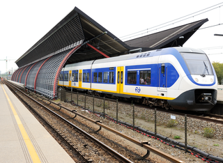
Amsterdam Zuid is a railway station situated in the borough of Amsterdam-Zuid in Amsterdam, Netherlands. For a number of years, it was named Amsterdam Zuid WTC, in reference to the neighbouring World Trade Center Amsterdam. During 2006, in conjunction with the rapid development of the area surrounding the station, the station was enlarged and the reference to the WTC was formally dropped from the name.

<span class="mw-page-title-main">Amsterdam Centraal station</span> Railway station in the Netherlands

Amsterdam Centraal station is the largest railway station in Amsterdam, North Holland, the Netherlands. A major international railway hub, it is used by 192,000 passengers a day, making it the second busiest railway station in the country after Utrecht Centraal and the most visited Rijksmonument of the Netherlands.

<span class="mw-page-title-main">Tramlijn 5</span>

Tramlijn 5 is a tram line operating between Amsterdam and Amstelveen in the Netherlands. Operated by the municipal transport company GVB, the route normally runs between Van Hallstraat in Amsterdam and Stadshart in the neighbouring municipality of Amstelveen. Tram line 5 connects several important areas of the city, including the Zuidas financial district and Leidseplein, and also provides a rapid tram route south of Amsterdam Zuid station to Stadshart, Amstelveen's town centre.

<span class="mw-page-title-main">Trams in Amsterdam</span>

The Amsterdam Tram is a tram network in Amsterdam, Netherlands. It dates back to 1875 and since 1943 has been operated by municipal public transport operator Gemeentelijk Vervoerbedrijf (GVB), which also runs the Amsterdam Metro and the city bus and ferry services. Amsterdam has the largest tram network in the Netherlands and one of the largest in Europe.

<span class="mw-page-title-main">Amsterdam RAI station</span> Railway station in Amsterdam, Netherlands

Amsterdam RAI is a railway station situated in southern Amsterdam, Netherlands. It is located between the two directions of the A10 Amsterdam ring road. It is also a metro station at which GVB runs two lines. The station takes its name from the nearby RAI Amsterdam Convention Centre.

<span class="mw-page-title-main">Amsterdam Lelylaan station</span>

Amsterdam Lelylaan is a railway, metro, tram and bus station in west Amsterdam. It is served by trains of the Nederlandse Spoorwegen and metros of the GVB. The station opened on 1 June 1986. It is located on the Amsterdam-Schiphol railway, a few km south of Amsterdam Sloterdijk railway station. South of this station, trains turn west towards Schiphol railway station, while metros turn east towards Amsterdam Zuid railway station. The station is located in the Amsterdam borough of Slotervaart, on a long viaduct spanning three roads.

<span class="mw-page-title-main">Diemen Zuid station</span> Railway and metro station in Diemen, Netherlands

Diemen Zuid is a railway station is located in Diemen, a city to the southeast of Amsterdam. The railway station is served by Nederlandse Spoorwegen (NS) services as well as line 53 of the Amsterdam Metro.

<span class="mw-page-title-main">Ferdinand Bolstraat</span>

The Ferdinand Bolstraat is a street in Amsterdam, named after the artist Ferdinand Bol in 1872.

<span class="mw-page-title-main">De Pijp</span> Neighbourhood of Amsterdam in North Holland, Netherlands

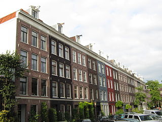
De Pijp is a neighbourhood of Amsterdam, Netherlands. It is located directly south of Amsterdam's city centre and it is part of the borough Amsterdam-Zuid, in a part of the city known as the Old South. It is served by De Pijp metro station. Most streets in De Pijp are named after Dutch painters, like Jan Steen, Frans Hals, Ruysdael and Vincent van Gogh. Diamantbuurt, Nieuwe Pijp and Oude Pijp are the three districts composing the area.

<span class="mw-page-title-main">Amstelveenseweg metro station</span> Metro station in Amsterdam

Amstelveenseweg is an Amsterdam Metro station in the south of Amsterdam, Netherlands. The station opened in 1997 and is served by line 50 and 51.

<span class="mw-page-title-main">Westwijk tram stop</span> Tram station in Amstelveen, Netherlands

Westwijk is a tram stop serving the neighborhood of Westwijk in the city of Amstelveen, Netherlands. It is the southern terminus of tram line 25, dubbed the Amsteltram before it received its line number. It opened officially on 13 December 2020, unofficially 4 days earlier on 9 December.

<span class="mw-page-title-main">De Boelelaan/VU tram stop</span> Tram station in Amsterdam, Netherlands

There were two tram stops with the name De Boelelaan/VU at or near the intersection of Parnassusweg/Buitenveldertselaan & De Boelelaan in Amsterdam. A combined metro/tram stop was located along Buitenveldertselaan on the south side of De Boelelaan, and a separate tram stop is located on the north side of De Boelelaan about 180 metres (590 ft) west of Parnassusweg. The information box (right) pertains to the former stop along Buitenveldertselaan.

A.J. Ernststraat is a tram stop within the city of Amsterdam, Netherlands. The stop serves tram lines 5 and 25. Line 25, dubbed the Amsteltram before receiving its line number, opened officially on 13 December 2020, unofficially 4 days earlier on 9 December.

<span class="mw-page-title-main">Poortwachter tram stop</span> Tram stop in Amstelveen, Netherland

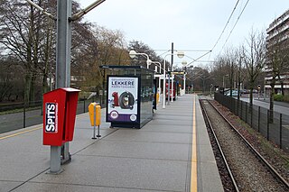
Poortwachter is a tram stop within the city of Amstelveen, Netherlands. The stop lies along tram line 25, which was dubbed the Amsteltram before it received its line number. It opened officially on 13 December 2020, unofficially 4 days earlier on 9 December.

<span class="mw-page-title-main">Sacharovlaan tram stop</span>

Sacharovlaan is a tram stop within the city of Amstelveen, Netherlands. The stop lies along tram line 25, which was dubbed the Amsteltram before it received its line number. It opened officially on 13 December 2020, unofficially 4 days earlier on 9 December. The tram stop serves the Legmeer business district.

<span class="mw-page-title-main">De Pijp metro station</span> Station on the North–South Line of the Amsterdam Metro

De Pijp metro station is a station on the Route 52 of the Amsterdam Metro in Amsterdam, Netherlands. It was opened on 22 July 2018. Prior to March 2012, this station was known as the Ceintuurbaan. De Pijp is an underground station situated in the Oude Pijp neighbourhood of the borough of Amsterdam-Zuid. The station is expected to handle around 18,000 passengers and arrivals per day.

<span class="mw-page-title-main">Amsteltram</span>

Amsterdam tram line 25, also known as the Amsteltram, is a tram line between Amsterdam Zuid station in Amsterdam and Westwijk in Amstelveen. It officially opened on 13 December 2020. Work is underway to extend the Amsteltram further south to the municipality of Uithoorn. The tram line replaced metro line 51, a light rail line (sneltram) that ceased running south of Amsterdam Zuid station on 3 March 2019 to convert it for low-floor trams. Tram line 5 shares the stops with line 25 between Zuid station and Oranjebaan stations. Line 5 had also shared the same tracks with metro line 51, the former using low-level platforms for regular trams, and the latter using high-level platforms.

<span class="mw-page-title-main">Line 51 (Amsterdam Metro)</span> Metro line in Amsterdam

M51, also known as the Ring Line, is an Amsterdam Metro line running from Amsterdam Centraal station to Isolatorweg metro station, almost creating a full circle through Amsterdam. It was opened in December 1990 as a metro/tram hybrid line named sneltram and served the suburb of Amstelveen. Using special rolling stock, the Amstelveen Line ran as a metro on 750 V DC third rail from Amsterdam Centraal to the Amsterdam Zuid station, where it would switch operation modes and utilize 600 V DC overhead lines and end at Poortwachter. An extension to Westwijk was completed in 2004. In Amstelveen, the line partially ran on the same track as tram line 5 and had many level crossings.

<span class="mw-page-title-main">Line 52 (Amsterdam Metro)</span>

Metro line 52, also known as the north–south line, is part of the Amsterdam metro network. The line starts in Amsterdam-Noord, continues under Amsterdam-Centrum to its terminus in Amsterdam Zuid station. It has six intermediate stops: Noorderpark, Centraal Station, Rokin, Vijzelgracht, De Pijp en Europaplein. The line was officially opened on 21 July 2018 by the mayor of Amsterdam, Femke Halsema and was opened to the public on the next day, 22 July 2018.

References

  1. "GVB". gvb.nl (in Dutch). Retrieved 2024-02-20.
  2. "Vervoerplan 2016 | Over GVB". 2015-09-19. Archived from the original on 2015-09-19. Retrieved 2024-02-20.
  3. Kruyswijk, Marc (2018-08-31). "Tram 24 voor lange tijd uit roulatie". Het Parool (in Dutch). Retrieved 2024-03-05.
  4. https://www.amsterdam.nl/projecten/rode-loper-entree/ferdinand-bolstraat/
  5. "Nieuw tramstation bij Amsterdam Zuid: ook voor Amstelveenlijn". amstelveenlijn.nl (in Dutch). Retrieved 2021-07-07.