
Haarlem is a city and municipality in the Netherlands. It is the capital of the province of North Holland. Haarlem is situated at the northern edge of the Randstad, one of the most populated metropolitan areas in Europe; it is also part of the Amsterdam metropolitan area. Haarlem had a population of 161,265 in 2019.

Haarlemmermeer is a municipality in the west of the Netherlands, in the province of North Holland. Haarlemmermeer is a polder, consisting of land reclaimed from water. The name Haarlemmermeer means Haarlem's lake, referring to the body of water from which the region was reclaimed in the 19th century.

De Adriaan is a windmill in the Netherlands that burnt down in 1932 and was rebuilt in 2002. The original windmill dates from 1779 and the mill has been a distinctive part of the skyline of Haarlem for centuries.

Haarlem railway station is located in Haarlem in North Holland, Netherlands. The station opened at September 20, 1839, on the Amsterdam–Rotterdam railway, the first railway line in the Netherlands. The station building itself is a rijksmonument.

The Hofje van Loo is a hofje on the Barrevoetstraat 7 in Haarlem, Netherlands.

The Bijlmermeer, or colloquially Bijlmer, is one of the neighbourhoods that form the Amsterdam-Zuidoost borough of Amsterdam, Netherlands. To many people, the Bijlmer designation is used to refer to Amsterdam Zuidoost as a pars pro toto. The other neighbourhoods in Amsterdam Zuidoost are Gaasperdam, Bullewijk, Venserpolder and Driemond.

Amsterdam Centraal Station is the largest railway station in Amsterdam, North Holland, the Netherlands. A major international railway hub, it is used by 192,000 passengers a day, making it the second busiest railway station in the country after Utrecht Centraal and the most visited Rijksmonument of the Netherlands.

The Singel is one of the canals of Amsterdam. The Singel encircled Amsterdam in the Middle Ages, serving as a moat around the city until 1585, when Amsterdam expanded beyond the Singel. The canal runs from the IJ bay, near the Central Station, to the Muntplein square, where it meets the Amstel river. It is now the inner-most canal in Amsterdam's semicircular ring of canals.
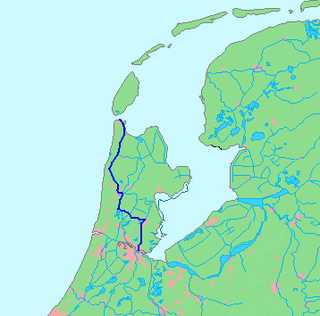
The Noordhollandsch Kanaal is a canal originally meant for ocean-going ships. It is located in North Holland, Netherlands. The canal was of great significance in Dutch history.
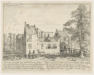
Berkenrode, or Berckenroode is a former 'Heerlijkheid' in the Dutch province of North Holland, situated on the southwest side of Haarlem on the leidsevaart, north of Iepenrode and west of Heemstede. The original castle Berkenrode in the center of the moat was burned by the Spanish during the siege of Haarlem in 1572. The castle was rebuilt and despite suffering another fire in 1747 the settlement continued to function as a separate municipality with its own chapel up to 1857, when the town was annexed by Heemstede. The town archives are now kept at the North Holland Archives in Haarlem.

The Haarlemmertrekvaart [ˌhaːrlɛmərˈtrɛkfaːrt] is a canal between Amsterdam and Haarlem in the province of North Holland, the Netherlands. It was dug in 1631, making it the oldest tow-canal in Holland. Travel on such canals was historically done by barges which were towed by animals on a path along the canal's edge (towpath).

The Leidsevaart is a canal between the cities of Haarlem and Leiden in the Netherlands. It was dug in 1657, making it one of the oldest canals in the Netherlands. It was the major means of transport between Leiden and Haarlem for almost two centuries until the rail connection was established in the 19th century. The original stops along the railway mirrored the toll bridges of the canal.
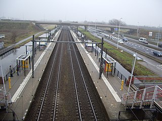
Haarlem Spaarnwoude is a railway station in Haarlem, Netherlands. It is located east of the Haarlem city centre and south of Spaarnwoude, on the Amsterdam–Rotterdam railway. The N200 road runs parallel to the railway on the south side. The station opened on 24 May 1998. On the north side of the station is an IKEA store.
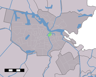
Lastage is a neighborhood in the Centrum borough of Amsterdam, Netherlands. It is located between the Geldersekade and Oudeschans canals, just east of old medieval city. Today, the neighbourhood is also known as Nieuwmarktbuurt due to the fact that the Nieuwmarkt is comprised in the area; it is protected as a heritage site.

The Waag is a 15th-century building on Nieuwmarkt square in Amsterdam. It was originally a city gate and part of the walls of Amsterdam. The building has also served as a guildhall, museum, fire station and anatomical theatre, among other things.
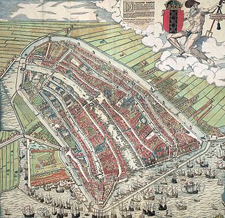
The walls of Amsterdam were built in the Middle Ages to protect the city against attack. The Medieval walls were replaced with a series of bastions in the 17th century. In the 19th century, the walls were torn down and replaced with the Defence Line of Amsterdam, a fortification line which encircled Amsterdam at a distance from the city.

The smallest house in Amsterdam is located at Oude Hoogstraat 22 in the old city center of Amsterdam, next to the Oost-Indisch Huis and the gate to the Walloon Church. The house, by some called the "Smallest house of Europe", is 2.02 meters wide and 5 meters deep. With its distinctive spout gable, this house represents a miniature version of a typical Amsterdam canal house.
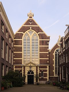
The Walloon Church is a Protestant church building in Amsterdam, along the southern stretch of the Oudezijds Achterburgwal canal. The building dates to the late 15th century and has been in use as a Walloon church since 1586. The church was also known as the Franse Kerk, Walenkerk, Oude Walenkerk, or Oude Waalse Kerk.

The Grimburgwal is a small canal and street in the center of Amsterdam.

The Spuistraat in downtown Amsterdam connects the Hekelveld to the Spui. It runs roughly north to south, parallel to the Singel and the Nieuwezijds Voorburgwal. At the Royal Palace of Amsterdam, the Spuistraat crosses the Raadhuisstraat and Paleisstraat. Originally the Spuistraat was a canal, the Nieuwezijds Achterburgwal. The canal was filled in in 1867, and the street renamed then.


