Anauayan Island

Last updated
Anauayan
Philippines relief location map (square).svg
Red pog.svg
Anauayan
Location within the Philippines
Geography
Coordinates 11°5′44″N123°9′17″E / 11.09556°N 123.15472°E / 11.09556; 123.15472 Coordinates: 11°5′44″N123°9′17″E / 11.09556°N 123.15472°E / 11.09556; 123.15472
Archipelago Concepcion Islands
Adjacent bodies of water
Length1.33 km (0.826 mi) [1]
Administration
Region Western Visayas
Province Iloilo
Municipality Concepcion

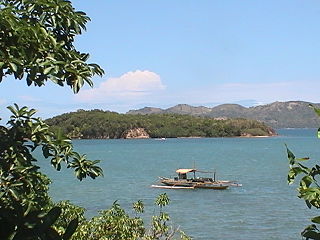
Anauayan Island is a small island in northeastern Iloilo, Philippines. It is part of the municipality of Concepcion.

Iloilo Province in Western Visayas, Philippines

Iloilo is a province located in the region of Western Visayas in the Philippines. Iloilo occupies a major southeast portion of the Visayan island of Panay and is bordered by the province of Antique to the west, Capiz to the north, the Jintotolo Channel to the northeast, the Guimaras Strait to the east, and the Iloilo Strait and Panay Gulf to the southwest.

Philippines Republic in Southeast Asia

The Philippines, officially the Republic of the Philippines, is an archipelagic country in Southeast Asia. Situated in the western Pacific Ocean, it consists of about 7,641 islands that are categorized broadly under three main geographical divisions from north to south: Luzon, Visayas, and Mindanao. The capital city of the Philippines is Manila and the most populous city is Quezon City, both part of Metro Manila. Bounded by the South China Sea on the west, the Philippine Sea on the east and the Celebes Sea on the southwest, the Philippines shares maritime borders with Taiwan to the north, Vietnam to the west, Palau to the east, and Malaysia and Indonesia to the south.

Concepcion, Iloilo Municipality of the Philippines in the province of Iloilo

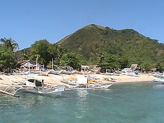
Concepcion, officially the Municipality of Concepcion, is a 3rd class municipality in the province of Iloilo, Philippines. According to the 2015 census, it has a population of 43,159 people.

Contents

Location and geography

Anauayan Island is southeast of Panay Island in the Visayan Sea. Part of the Concepcion Islands, it is 2 miles (3.2 km) southeast of Tagubanhan Island. Anauayan is separated from Panay by a deep channel and is 54 metres (177 ft) at its highest point. [2]

Panay island in the Philippines

Panay is the sixth-largest and fourth most-populous island in the Philippines, with a total land area of 12,011 km2 (4,637 sq mi) and with a total population of 4,477,247. Panay comprises 4.4 percent of the entire population of the country. The City of Iloilo is its largest settlement with a total population of 447,992 inhabitants. It is a triangular island, located in the western part of the Visayas. It is about 160 km (99 mi) across. It is divided into four provinces: Aklan, Antique, Capiz and Iloilo, all in the Western Visayas Region. It is located southeast of the island of Mindoro and northwest of Negros across the Guimaras Strait. Just off the mid-southeastern coast lies the island-province of Guimaras. To the north and northeast is the Sibuyan Sea, Jintotolo Channel and the islands of Romblon and Masbate; to the west and southwest is the Sulu Sea and the Palawan archipelago and to the south is Panay Gulf. Panay is the only main island in the Visayas whose provinces don't bear the name of their island.

Visayan Sea A sea in the Philippines between Masbate, Leyte, Cebu, Negros and Panay

The Visayan Sea is a sea in the Philippines surrounded by the islands of the Visayas: Western Visayas, Eastern Visayas, and Central Visayas to the south. It is bounded by the islands Masbate to the north, Panay to the west, Leyte to the east, and Cebu & Negros to the south.

Concepcion Islands

The Concepcion Islands are 17 variously inhabited and uninhabited islands in northeastern Iloilo, Philippines. The islands are politically subdivided into 11 island barangays and are part of the municipality of Concepcion. Collectively, the islands have -according to 2010 census- a population of 19,080, which is 48 percent the total population of Concepcion.

See also

Related Research Articles

Western Visayas Region in Visayas, Philippines

Western Visayas is an administrative region in the Philippines, numerically designated as Region VI. It consists of six provinces and two highly urbanized cities. The regional center is Iloilo City. The region is dominated by the native speakers of four Visayan languages: Kinaray-a, Hiligaynon, Aklanon and Capiznon. The land area of the region is 20,794.18 km2 (8,028.68 sq mi), and with a population of 7,536,383 inhabitants, it is the most populous region in the Visayas.

Igbon Island island

Igbon Island is an island and barangay in northeastern Iloilo, Philippines. It is part of the municipality of Concepcion. According to the 2010 census, it has a population of 2,547. The island is moderately known in the Philippines for its scuba diving.

Pan de Azucar Island (Iloilo) island in the Philippines

Pan de Azucar is a populated island in the Visayan Sea in the Philippines. The island is known for MountPan de Azucar a steep volcanic cone and a prominent landmark at the northern entrance of Guimaras Strait.

Tago Island island in Philippines

Tago Island is a mountain, which is also the eponymous whole island, in northeastern Iloilo, Philippines. It is part of the municipality of Concepcion.

Botlog Island

Botlog Island is an island and barangay in northeastern Iloilo, Philippines. It is part of the municipality of Concepcion. According to the 2010 census, it has a population of 441.

Malangabang

Malangabang is an island and barangay in northeastern Iloilo, Philippines. It is part of the municipality of Concepcion. According to the 2010 census, it has a population of 2,925. Fishing is the main source of income for the island's residents.

Bulubadiangan Island

Bulubadiangan Island is a privately owned island in northeastern Iloilo, Philippines. It is part of barangay Polopińa, Concepcion. The Sandbar Island Beach Resort on Bulubadiangan is moderately known within the Philippines.

Danao-Danao Island

Danao-Danao Island is a small, low-lying island in northeastern Iloilo, Philippines. It is part of the municipality of Concepcion.

Baliguian Island

Baliguian Island is an inhabited island in northeastern Iloilo, Philippines. It is the westernmost of the Concepcion Islands and politically administered by the municipality of Concepcion. A virtually flat island, Baliguian features a lighthouse to aid in ship navigation.

Bocot Island

Bocot Island is a small island in northeastern Iloilo, Philippines. It is part of the municipality of Concepcion.

Bag-o Isi Island

Bag-o Isi Island is a small island in northeastern Iloilo, Philippines. It is part of the municipality of Concepcion.

Sombrero Island (Iloilo)

Sombrero is a small, cone-shaped island in northeastern Iloilo, Philippines. It is part of the municipality of Concepcion.

Tagubanhan Island

Tagubanhan Island is a wooded island in northeastern Iloilo, Philippines. It is part of the municipality of Concepcion.

Bag-o Abo

Bag-o Abo is a small, wooded island in northeastern Iloilo, Philippines. It is part of the municipality of Concepcion.

Chico Island (Iloilo)

Chico is an uninhabited island in northeastern Iloilo, Philippines. It is part of the municipality of Concepcion. The island is owned by the heirs of Consuelo and Zacarias Bagaforo of Malangabang Island.

Colebra Island

Colebra is an island in northeastern Iloilo, Philippines. It is part of the municipality of Concepcion.

Nabunot

Nabunot is an island in northeastern Iloilo, Philippines. It is one of fourteen islands politically administered by the municipality of Carles.

References

  1. "Anauayan Island". Geoview.info. Retrieved 8 July 2014.
  2. "Sailing Directions (Enroute) Philippine Islands" (PDF). National Geospatial-Intelligence Agency. 2008. p. 96. Retrieved 8 July 2014.