Andaman district

Last updated

Andaman district
former district of India
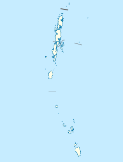
India Andaman and Nicobar Islands location map.svg
Red pog.svg
Coordinates: 11°40′00″N92°45′00″E / 11.6667°N 92.75°E / 11.6667; 92.75 Coordinates: 11°40′00″N92°45′00″E / 11.6667°N 92.75°E / 11.6667; 92.75
Country India
Union territory Andaman and Nicobar Islands

Andaman district was a district of India, one of three districts in the Indian Union Territory (UT) of Andaman and Nicobar Islands. The district's administrative territory encompasses all of the Andaman Islands, which are located in the Indian Ocean (Bay of Bengal, bordering with the Andaman Sea). The district government is headed by a Deputy Commissioner, who in turn reports into the Lt. Governor of the Andaman and Nicobar Islands.

The capital of the district is the township of Port Blair, which is also the main town and capital of Andaman and Nicobar Islands UT. The district was severely affected by the tsunami that was caused by the 2004 Indian Ocean earthquake, which led to many deaths and damaged infrastructure.
Geography

There are approximately 550 islands which made up the Andaman district, 26 of which are inhabited. The total population of Andaman district as per 2001 Census of India figures was 314,084. The district had a total area of some 6,408 km2. Approximately 90% of the islands are forested or uncultivated; urban area is only 16.6 km2.

Divisions

The district comprised two sub-divisions, North & Middle Andaman (Mayabunder), and South & Little Andaman (Port Blair), which were turned into districts by splitting the Andaman district on August 18, 2006.


Related Research Articles

Andaman Islands Archipelago in the Bay of Bengal

The Andaman Islands are an archipelago in the northeastern Indian Ocean about 130 km (81 mi) southwest off the coasts of Myanmar's Ayeyarwady Region. Together with the Nicobar Islands to their south, the Andamans serve as a maritime boundary between the Bay of Bengal to the west and the Andaman Sea to the east. Most of the islands are part of the Andaman and Nicobar Islands, a Union Territory of India, while the Coco Islands and Preparis Island are part of the Yangon Region of Myanmar.

Andaman and Nicobar Islands Union territory of India

Andaman and Nicobar Islands is a union territory of India consisting of 572 islands, of which 38 are inhabited, at the junction of the Bay of Bengal and the Andaman Sea. The territory is about 150 km (93 mi) north of Aceh in Indonesia and separated from Thailand and Myanmar by the Andaman Sea. It comprises two island groups, the Andaman Islands (partly) and the Nicobar Islands, separated by the 150 km wide Ten Degree Channel, with the Andaman islands to the north of this latitude, and the Nicobar islands to the south. The Andaman Sea lies to the east and the Bay of Bengal to the west. The island chains are thought to be a submerged extension of the Arakan Mountains.

Car Nicobar One of the Nicobar Islands

Car Nicobar is the northernmost of the Nicobar Islands. It is also one of three local administrative divisions of the Indian district of Nicobar, part of the Indian union territory of Andaman and Nicobar Islands.

Port Blair Capital city of the Andaman and Nicobar Islands, India

Port Blair is the capital city of the Andaman and Nicobar Islands, a union territory of India in the Bay of Bengal. It is also the local administrative sub-division (tehsil) of the islands, the headquarters for the district of South Andaman and is the territory's only notified town.

South Andaman Island

South Andaman Island is the southernmost island of the Great Andaman and is home to the majority of the population of the Andaman Islands. It belongs to the South Andaman administrative district, part of the Indian union territory of Andaman and Nicobar Islands. It is the location of Port Blair, capital of the Andaman and Nicobar Islands.

North Andaman Island

North Andaman Island is the northern island of Great Andaman of the Andaman Islands. It belongs to the North and Middle Andaman administrative district, part of the Indian union territory of Andaman and Nicobar Islands. the island is lying 137 km (85 mi) north from Port Blair.

Little Andaman Island in India

Little Andaman Island is the fourth largest of the Andaman Islands of India with an area of 707 km², lying at the southern end of the archipelago. It belongs to the South Andaman administrative district, part of the Indian union territory of Andaman and Nicobar Islands. It lies 88 km (55 mi) south of Port Blair, the capital of Andaman and Nicobar Islands.

Great Nicobar Island

Great Nicobar is the southernmost and largest of the Nicobar Islands of India, north of Sumatra.

Indira Point Village in Andaman and Nicobar Islands, India

Indira Point, southernmost point of India's territory, is a village in the Nicobar district at Great Nicobar Island of Andaman and Nicobar Islands in India. It is located in the Great Nicobar tehsil.

Barren Island (Andaman Islands)

Barren Island is an island located in the Andaman Sea. It is the only confirmed active volcano in the Indian subcontinent, and the only active volcano along a chain of volcanoes from Sumatra to Myanmar. It is a part of the Indian Union territory of Andaman and Nicobar Islands, and lies about 138 km (86 mi) northeast of the territory's capital, Port Blair.

Baratang Island Indian island of the Andaman chain

Baratang Island is an island of the Andaman Islands. It belongs to the North and Middle Andaman administrative district, part of the Indian union territory of Andaman and Nicobar Islands. The island lies 150 km (93 mi) north of Port Blair.

Port Blair tehsil is one of 5 local administrative divisions of the Indian district of South Andaman, part of the Indian union territory of Andaman and Nicobar Islands.

Galathea National Park is a National Park located in the Union Territory of Andaman and Nicobar Islands, India. It is located on the island of Great Nicobar in the Nicobar Islands, which lie in the eastern Indian Ocean.

South Andaman district district of India in Andaman and Nicobar Islands

South Andaman district is one of the 3 districts of the Indian Union Territory of Andaman and Nicobar Islands located in the Bay of Bengal. Port Blair town, the capital of the Union Territory is the district headquarters. The area covered by this district is 2,640 km².

Andaman and Nicobar Command tri-services command of the Indian Armed Forces

The Andaman and Nicobar Command (ANC) is the first and only tri-service theater command of the Indian Armed Forces, based at Port Blair in the Andaman and Nicobar Islands, a Union Territory of India. It was created in 2001 to safeguard India's strategic interests in Southeast Asia and the Strait of Malacca by increasing rapid deployment of military assets in the region. It provides logistical and administrative support to naval ships which are sent on deployment to East Asia and the Pacific Ocean.

Campbell Bay (Great Nicobar) village in Andaman and Nicobar Islands, India

Campbell Bay is a village in the Nicobar district of Andaman and Nicobar Islands, India. It is located in the Great Nicobar tehsil. The island's Indira Point is famous for being the southernmost point of India.

Landfall Island

Landfall Island is the northernmost island of the Indian union territory of Andaman and Nicobar Islands. It belongs to the territory's North and Middle Andaman administrative district. The island lies 220 km (137 mi) north of Port Blair, and is situated 300 km (186 mi) south of Myanmar. It is home to the Kari tribe.

Tourism in Andaman and Nicobar Islands relates to tourism in union territory of India, Andaman and Nicobar Islands. The Andamans are an archipelago of over 570 tropical islands, of which only 36 are inhabited. In 2004 Radhanagar beach at Havelock Island was bestowed with the title of "Asia’s Best Beach" and as the world's seventh most spectacular beach by Time Magazine.

East Island (Andaman and Nicobar Islands)

East Island is an island of the Andaman Islands. It belongs to the North and Middle Andaman administrative district, part of the Indian union territory of Andaman and Nicobar Islands. the island is lying 220 km (137 mi) north from Port Blair.

The Andaman and Nicobar Islands is an archipelago of 572 islands of which 37 are inhabited. It is a union territory of India.