The Karmanasa River is a tributary of the Ganges. It originates in Kaimur district of Bihar and flows through the Indian states of Uttar Pradesh and Bihar. Along the boundary between Uttar Pradesh and Bihar it has the districts of Sonbhadra, Chandauli, Varanasi and Ghazipur on its left ; and the districts of Kaimur and Buxar on its right.

The Mahi is a river in western India. It rises in Madhya Pradesh and, after flowing through the Vagad region of Rajasthan, enters Gujarat and flows into the Arabian Sea. It is one of the relatively few west-flowing rivers in India, alongside the endorheic Luni River, the Sabarmati River, the Tapi River and the Narmada River. Most peninsular rivers in India flow eastward into the Bay of Bengal or northward into the Ganges River.
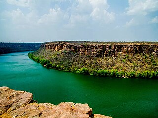
The Chambal River is a tributary of the Yamuna River in Central and Northern India, and thus forms part of the drainage system of the Ganges. The river flows north-northeast through Madhya Pradesh, running for a time through Rajasthan then forming the boundary between Rajasthan and Madhya Pradesh before turning southeast to join the Yamuna in Uttar Pradesh state.

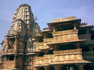
Chanderi, is a town of historical importance in Ashoknagar District of the state Madhya Pradesh in India. It is situated at a distance of 127 km from Shivpuri, 37 km from Lalitpur, 55 km from Ashok Nagar and about 46 km from Isagarh. It is surrounded by hills southwest of the Betwa River. Chanderi is surrounded by hills, lakes and forests and is spotted with several monuments of the Bundela Rajputs and Malwa sultans. It is famous for ancient Jain Temples. Its population in 2011 was 33,081.
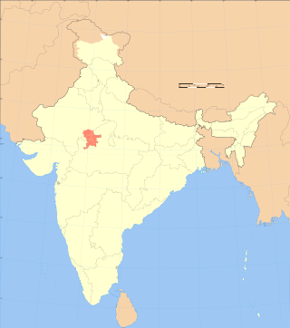
Hadoti is a region of Rajasthan state in western India, which was once called the Bundi Kingdom. The biggest cities are Jhalawar and Kota. It includes the districts of Bundi, Baran, Jhalawar and Kota and is bounded on the west by the Mewar, on the northwest by Ajmer regions of Rajasthan, and on the south by the Malwa, on the east by the Gird regions of Madhya Pradesh state.
Vagad is a region in southeastern Rajasthan state of western India. Its boundaries are roughly defined by those of the districts of Dungarpur and Banswara. Major cities of the region are Dungarpur and Banswara.

The Kali Sindh, is a river in Madhya Pradesh and Rajasthan in northern India. It is a tributary of the Chambal River in the Ganges Basin. The main tributaries of the Kali Sindh are the Parwan, Niwaj and Ahu rivers. The Kali Sindh River drains a major portion of the Malwa region, and is the biggest river flowing in the Malwa region of Madhya Pradesh.

Parvati River is a river in Madhya Pradesh and Rajasthan, India that flows into the Chambal River. The river rises at a height of 610 m in the Vindhya range in Sehore district Madhya Pradesh And flows in Sehore District, Rajgarh District, Guna District of Madhya Pradesh and then enters in Rajasthan and flows from Baran District and Sawai Madhopur District of Rajasthan where it falls into Chambal River in Sawai Madhopur District and runs for 436 km. It is one of the Chambal River's three main tributaries, along with the Banas River and the Kali Sindh River. Ramgarh crater is located on its eastern bank. Many small villages and tribes are situated on its bank, which utilise it for various purposes, such as irrigation, drinking, washing, etc.

The Ochre Coloured Pottery culture (OCP) is a Bronze Age culture of the Indo-Gangetic Plain "generally dated 2000–1500 BCE," extending from eastern Punjab to northeastern Rajasthan and western Uttar Pradesh.

Guna district is one of the 52 districts of Madhya Pradesh in central India. Its administrative headquarters is Guna. The district has a population of 1,241,519. It has an area of 6390 km², and is bounded on the northeast by Shivpuri District, on the east by Ashoknagar District, on the southeast by Vidisha District, on the southwest by Rajgarh District, on the west and northwest by Jhalawar and Baran districts of Rajasthan state. The Sindh River flows northward along the eastern edge of the district, forming part of the boundary with Ashoknagar District, and the Parvati River flows northwestward through the southern portion of the district, forming part of the boundary with Baran District before flowing into Rajasthan.

Shivpuri District is a district of Madhya Pradesh state of India. The town of Shivpuri is the district headquarters. National Highway 3 (NH-3) runs through the district.

Gangaur is a Hindu festival celebrated in the Indian states of Rajasthan, Haryana, Malwa, Nimaad regions of Madhya Pradesh, Braj and Bundelkhand regions in Uttar Pradesh and Madhya Pradesh. It is also celebrated in some parts of Gujarat and West Bengal. A variation of same festival known as "Chaitra Gauri Vrat" is observed on the same day in the states of Maharashtra & North Karnataka. Another variation called 'Saubhagya Gauri Vratam' is observed in the states of Telangana and Andhra Pradesh.
Baran is a city in Baran district of the Indian state of Rajasthan. It is a municipality and the district headquarters of Baran district, famous for its 11th century Bhand Devra Temple on banks of Ramgarh crater. It is 339km from the state capital Jaipur near Kota city. Three large rivers, Parban, Parbati, and Kalisindh, flow through the district.
Bagli is a town and a nagar panchayat in the Malwa region of Dewas district in the state of Madhya Pradesh, India. Bagli is around 66 km (41 mi) from Dewas.
The origin of Jawai river is in the hills of Goriya village of Bali town, located on the border of Pali and Udaipur districts.

Parban River originates in Madhya Pradesh and flows through Rajasthan. It is a tributary of the Kali Sindh. Parban/Parvan originates in Sehore district of Madhya Pradesh and flows through Sehore, Shajapur and Rajgarh districts in Madhya Pradesh. It also flows through Jhalawar, Kota, Baran districts of Rajasthan. Before it joins the Kali Sindh it cuts a 10 km long valley of significant depth right across Ratibar Dungar near Akawad Kalan in Jhalawar district. It meets Kali Sindh in Baran district of Rajasthan. Shergarh wildlife Sanctuary situated at the bank of Parban river in Baran district.
Atru railway station is a railway station in Baran district, Rajasthan. Its code is ATRU. It serves Atru town. The station consists of 2 platforms. Passenger, Express, and Superfast trains halt here.
The Chandrabhaga River is a river in India that originates from the hills of Amet area in Rajsamand district and flows to join the Banas River in Bhilwara district.
The Retili River is a river in India, originating near Gopalgarh village in Madhya Pradesh and flowing in Bara district of Rajasthan. It joins the Parvati River near Ganeshpura village.
The Gunjali River is a river in India that originates in the hills of Ratangarh Tahsil in the Nimach District of Madhya Pradesh. It flows eastward and enters Chittorgarh District near Daulatpura. The river then passes through the areas of Moren, Amarganj, and Kua Khera within Chittorgarh District. Finally, it joins the Chambal River at Arnia Village.
