
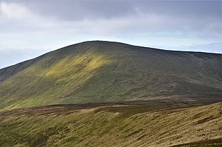
Tinto is an isolated hill in the south of the Central Lowlands just to the north of the Southern Uplands of Scotland. It comprises little more than one top, which stands on the west bank of the River Clyde, some eight kilometres west of Biggar. The peak is also called "Tinto Tap", with the name Tinto possibly deriving from the Scottish Gaelic word teinnteach, meaning "fiery", which may refer to its ancient past as a look out beacon. Further known as the "Hill of Fire" it is also suggested exposed red hue felsite rock visible in many places on the hill helped give rise to this name due to the effect seen when a setting sun illuminates the hillside.

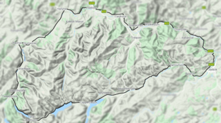
The Southern Upland Way is a 344-kilometre (214 mi) coast-to-coast long-distance footpath in southern Scotland. The route links Portpatrick in the west and Cockburnspath in the east via the hills of the Southern Uplands. The Way is designated as one of Scotland's Great Trails by NatureScot and is the longest of the 29 Great Trails. The Southern Upland Way meets with seven of the other Great Trails: the Annandale Way, the Berwickshire Coastal Path, the Borders Abbeys Way, the Cross Borders Drove Road, the Mull of Galloway Trail, the Romans and Reivers Route and St Cuthbert's Way.

Broad Law is a hill in the Manor Hills range, part of the Southern Uplands of Scotland. The second-highest point in the Southern Uplands and the highest point in the Scottish Borders, it has an elevation of 840 metres, a prominence of 653 metres and an isolation of 81 kilometres. It is only 3 m (10 ft) lower than its parent, Merrick. Like many of its neighbours it is smooth, rounded and grassy, although the surrounding glens have very steep sides — country somewhat akin to the Cheviots or the Howgill Fells. The hill is most easily climbed from the Megget Stane to the south, beginning at an elevation of 452 m (1,483 ft), but is also frequently climbed from the villages near its base, or as part of a long, 50 km (30 mi) trek across the local area between the towns of Peebles and Moffat. On the summit is the highest VOR beacon in the UK, and also a radio tower.
Culter Fell is a hill in the Culter Hills range, part of the Southern Uplands of Scotland. It is the county top of the historic county of Lanarkshire, as well as the highest point in South Lanarkshire council area. It is the culmination of a network of ridges that lie south of the village of Coulter, close to the town of Biggar.

The Moorfoot Hills are a range of hills south of Edinburgh in east central Scotland, one of the ranges which collectively form the Southern Uplands.

Kirriereoch Hill is a hill in the Range of the Awful Hand, a sub-range of the Galloway Hills range, part of the Southern Uplands of Scotland. It lies on the border of the old counties of Ayrshire and Kirkcudbrightshire, or the modern regions of Dumfries and Galloway and South Ayrshire. A boundary wall near the summit is the highest point in South Ayrshire and Ayrshire as a whole. Kirriereoch Hill was classified as a Corbett and Marilyn but then deleted from these lists in 1984 due to not being thought to achieve the respective prominence criteria. In August 2015 the hill was relisted as a Marilyn after having been surveyed to have a 150.2 m prominence. However, since this is less than the 152.4 m required, the hill will not be re-listed as a Corbett.
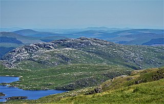
Craignaw is a hill in the Dungeon Hills, a sub-range of the Galloway Hills range, part of the Southern Uplands of Scotland. Unlike many hills in the Southern Uplands, Craignaw has a complex and rocky summit area, with a long line of crags and rough ground on the east side. The hill is largely composed of granite. Near the north end of the hill is an interesting area of terrain known as the "Deil's Bowlin' Green" where various rounded granite boulders are scatterd at random over an area of nearly horizontal granite slabs. These are believed to be glacial erratics or result from a similar glacier process. On the west side of the hill, near grid reference NX458831, a few hundred meters from the summit is an F-111E Aardvark crash site. The site is marked by a small memorial to the two U.S. Air Force pilots who were killed in the accident. Although the crash happened on 19 December 1979 there are still small amounts of aircraft debris in the area.

Lamachan Hill is a hill in the Minnigaff Hills, a sub-range of the Galloway Hills range, part of the Southern Uplands of Scotland. It is the highest hill of the range, lying 11 kilometres (7 mi) north of Newton Stewart in Dumfries and Galloway.

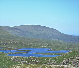
White Coomb is a hill in the Moffat Hills range, part of the Southern Uplands of Scotland. Its broad summit is the highest point in the range and the registration county of Dumfriesshire, as well as being the fourth highest point in southern Scotland, however, despite this, it is largely concealed by other hills on all sides except its east and south east, making this the only direction from which its full scale can be seen.
Shalloch on Minnoch is a hill in the Range of the Awful Hand, a sub-range of the Galloway Hills range, part of the Southern Uplands of Scotland. It is frequently climbed from Stinchar bridge to the north, or as part of a full traverse of the range.

Croft Head is a hill in the Ettrick Hills range, part of the Southern Uplands of Scotland. It offers unobstructed views to the Solway Firth, the fells and mountains of Cumbria and the Pennines to the south and east. To the north, the major Moffat Hills are close by and to the west, Queensberry, the Lowthers and many of the Galloway Hills can be seen. Its summit is easily reached from Moffat by taking the Southern Upland Way path east from the Moffat water bridge near Craigbeck. A quite dramatic ridge loop is possible by climbing north on the forestry fire road shortly after Craigbeck Hope cottage via Gateshaw Rig to Croft Head's summit and descending via Cat Shoulder to the junction of the SUW and the Selcoth burn pass.
Cape Law is a hill in the Moffat Hills range, part of the Southern Uplands of Scotland. A sprawling summit, it is commonly ascended from Talla Linfoots to the north on the way to the higher summits to the west and east.

Molls Cleuch Dod is a hill in the Moffat Hills range, part of the Southern Uplands of Scotland. A broad, grassy outlier of the surrounding hills, it is commonly ascended in rounds beginning from the Megget Stane and Talla Linnfoots or as a detour from the Grey Mare's Tail.

Under Saddle Yoke is a hill in the Moffat Hills range, part of the Southern Uplands of Scotland. Despite its name, it is 10m higher than its neighbouring top, Saddle Yoke. Located in a dramatic position on a small, grassy ridge in between two deep glens, Blackhope and Carrifran, it awards excellent views into the rest of the Moffat Hills and the Ettrick Hills opposite. Although incomparable to the Scottish Highlands and not particularly precipitous, the ridge between and atop the Yokes is the narrowest summit ridge in the Southern Uplands. The electric fence that comes out of Blackshope and crosses the ridge to the north of Saddle Yoke and then continues down into Carrifran hasn't worked in 40 years. A popular round known as the Hart Fell Horseshoe begins near Blackshope and normally ascends Nether Coomb Craig first, then passing over Swatte Fell, Hart Fell and looping round Hartfell Rig to the Saddle Yokes before the descent.

Hart Fell is a hill in the Moffat Hills range, part of the Southern Uplands of Scotland. It lies north of the town of Moffat on the border with the Scottish Borders and Dumfries and Galloway.
The Manor Hills, also known as the Tweedsmuir Hills, are a range of hills south of Peebles in the Scottish Borders, one of the ranges which collectively form the Southern Uplands. They are separated from the Moffat Hills by the Talla Reservoir, Megget Reservoir and St. Mary's Loch, the Moorfoot Hills by the A72 and the Culter Hills in South Lanarkshire by the A701. The western portion of the hills are designated as the 'Tweedsmuir Hills' Site of Special Scientific Interest and the 'Upper Tweeddale' National Scenic Area, with the major tributary rivers designated as Special Areas of Conservation.
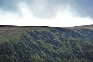
Swatte Fell is a hill in the Moffat Hills range, part of the Southern Uplands of Scotland. It lies north of the town of Moffat in Dumfries and Galloway, south of its parent peak, Hart Fell. It is gently sloping on three sides of the hill, however the east ridge is steep and craggy and features a deep corrie known as Blackhope, from which a popular rock climb, the Coomb Craig ridge, originates, finishing near the summit, and was featured on the OS Explorer 330 map front cover. The normal route is from the southern ridge and can be extended to include a full loop of Blackhope, finishing on Saddle Yoke, known as the Hart Fell Horseshoe.

Ballencleuch Law is a hill in the Lowther Hills range, part of the Southern Uplands of Scotland. Surrounded on most sides by tracks or roads, there are various routes to the summit, but the most frequent ascents are from Durisdeer or the Daer Reservoir.

Bell Craig is a hill in the Ettrick Hills range, part of the Southern Uplands of Scotland. It is part of a ridge that runs parallel to the A708 road on its southern side, with White Coomb in the Moffat Hills directly opposite. The northern slopes are designated as part of the 'Moffat Hills' SSSI and SAC - the summit marks a corner of the area.

The Ettrick Hills are a range of hills that are part of the Southern Uplands of Scotland. They are neighboured to the northwest by the Moffat Hills and are located mainly within the Scottish Borders; however, the Dumfries and Galloway border covers the south and southwesterly flanks.

