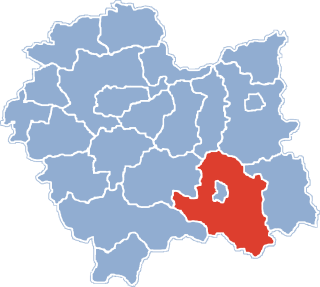
Nowy Sącz County is a unit of territorial administration and local government (powiat) in Lesser Poland Voivodeship, southern Poland, on the Slovak border. It came into being on January 1, 1999, as a result of the Polish local government reforms passed in 1998. Its administrative seat is the city of Nowy Sącz, although the city is not part of the county. The county contains five towns: Krynica-Zdrój, 31 km (19 mi) south-east of Nowy Sącz, Stary Sącz, 9 km (6 mi) south-west of Nowy Sącz, Grybów, 19 km (12 mi) east of Nowy Sącz, Piwniczna-Zdrój, 21 km (13 mi) south of Nowy Sącz, and Muszyna, 33 km (21 mi) south-east of Nowy Sącz.

Królowa Polska is a village in the administrative district of Gmina Kamionka Wielka, within Nowy Sącz County, Lesser Poland Voivodeship, in southern Poland. It lies approximately 4 kilometres (2 mi) north-east of Kamionka Wielka, 10 km (6 mi) east of Nowy Sącz, and 82 km (51 mi) south-east of the regional capital Kraków.

Polany is a village in the administrative district of Gmina Krynica-Zdrój, within Nowy Sącz County, Lesser Poland Voivodeship, in southern Poland, close to the border with Slovakia. It lies approximately 14 kilometres (9 mi) north of Krynica-Zdrój, 23 km (14 mi) south-east of Nowy Sącz, and 96 km (60 mi) south-east of the regional capital Kraków.
Tylicz is a village in the administrative district of Gmina Krynica-Zdrój, within Nowy Sącz County, Lesser Poland Voivodeship, in southern Poland, close to the border with Slovakia. It lies approximately 6 kilometres (4 mi) east of Krynica-Zdrój, 35 km (22 mi) south-east of Nowy Sącz, and 108 km (67 mi) south-east of the regional capital Kraków.
Barnowiec is a village in the administrative district of Gmina Łabowa, within Nowy Sącz County, Lesser Poland Voivodeship, in southern Poland. It lies approximately 7 kilometres (4 mi) west of Łabowa, 14 km (9 mi) south-east of Nowy Sącz, and 86 km (53 mi) south-east of the regional capital Kraków.
Krzyżówka is a village in the administrative district of Gmina Łabowa, within Nowy Sącz County, Lesser Poland Voivodeship, in southern Poland. It lies approximately 9 kilometres (6 mi) south-east of Łabowa, 25 km (16 mi) south-east of Nowy Sącz, and 97 km (60 mi) south-east of the regional capital Kraków.
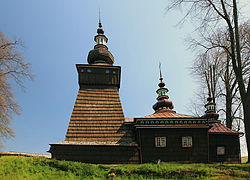
Łosie is a village in the administrative district of Gmina Łabowa, within Nowy Sącz County, Lesser Poland Voivodeship, in southern Poland. It lies approximately 9 kilometres (6 mi) south-east of Łabowa, 24 km (15 mi) south-east of Nowy Sącz, and 97 km (60 mi) south-east of the regional capital Kraków.
Obidza is a village in the administrative district of Gmina Łącko, within Nowy Sącz County, Lesser Poland Voivodeship, in southern Poland. It lies approximately 8 kilometres (5 mi) south-east of Łącko, 18 km (11 mi) south-west of Nowy Sącz, and 74 km (46 mi) south-east of the regional capital Kraków.
Zarzecze is a village in the administrative district of Gmina Łącko, within Nowy Sącz County, Lesser Poland Voivodeship, in southern Poland. It lies approximately 2 kilometres (1 mi) south-west of Łącko, 22 km (14 mi) west of Nowy Sącz, and 67 km (42 mi) south-east of the regional capital Kraków.
Dubne is a village in the administrative district of Gmina Muszyna, within Nowy Sącz County, Lesser Poland Voivodeship, in southern Poland, close to the border with Slovakia. It lies approximately 8 kilometres (5 mi) south-east of Muszyna, 40 km (25 mi) south-east of Nowy Sącz, and 112 km (70 mi) south-east of the regional capital Kraków.

Leluchów is a village in the administrative district of Gmina Muszyna, within Nowy Sącz County, Lesser Poland Voivodeship, in southern Poland, close to the border with Slovakia. It lies approximately 7 kilometres (4 mi) south of Muszyna, 40 km (25 mi) south-east of Nowy Sącz, and 111 km (69 mi) south-east of the regional capital Kraków.
Łopata Polska is a hamlet in the Żegiestów at the administrative district of Gmina Muszyna, within Nowy Sącz County, Lesser Poland Voivodeship, in southern Poland, close to the border with Slovakia. It lies approximately 8 kilometres (5 mi) west of Muszyna, 31 km (19 mi) south of Nowy Sącz, and 100 km (62 mi) south-east of the regional capital Kraków.
Milik is a village in the administrative district of Gmina Muszyna, within Nowy Sącz County, Lesser Poland Voivodeship, in southern Poland, close to the border with Slovakia. It lies approximately 5 kilometres (3 mi) north-west of Muszyna, 29 km (18 mi) south-east of Nowy Sącz, and 100 km (62 mi) south-east of the regional capital Kraków. It is located in the valley of the Milik river — a tributary of the Poprad.
Szczawnik is a village in the administrative district of Gmina Muszyna, within Nowy Sącz County, Lesser Poland Voivodeship, in southern Poland, close to the border with Slovakia. It lies approximately 4 kilometres (2 mi) north-west of Muszyna, 30 km (19 mi) south-east of Nowy Sącz, and 101 km (63 mi) south-east of the regional capital Kraków.
Złockie is a village in the administrative district of Gmina Muszyna, within Nowy Sącz County, Lesser Poland Voivodeship, in southern Poland, close to the border with Slovakia. It lies approximately 3 kilometres (2 mi) north of Muszyna, 31 km (19 mi) south-east of Nowy Sącz, and 103 km (64 mi) south-east of the regional capital Kraków.

Juraszowa is a village in the administrative district of Gmina Podegrodzie, within Nowy Sącz County, Lesser Poland Voivodeship, in southern Poland. It lies approximately 2 kilometres (1 mi) west of Podegrodzie, 12 km (7 mi) south-west of Nowy Sącz, and 72 km (45 mi) south-east of the regional capital Kraków.
Naszacowice is a village in the administrative district of Gmina Podegrodzie, within Nowy Sącz County, Lesser Poland Voivodeship, in southern Poland. It lies approximately 11 km (7 mi) south-west of Nowy Sącz and 72 km (45 mi) south-east of the regional capital Kraków.
Podrzecze is a village in the administrative district of Gmina Podegrodzie, within Nowy Sącz County, Lesser Poland Voivodeship, in southern Poland. It lies approximately 7 kilometres (4 mi) north-east of Podegrodzie, 5 km (3 mi) south-west of Nowy Sącz, and 73 km (45 mi) south-east of the regional capital Kraków.
Krogule is a village in the administrative district of Gmina Nasielsk, within Nowy Dwór Mazowiecki County, Masovian Voivodeship, in east-central Poland. It lies approximately 6 kilometres (4 mi) south of Nasielsk, 16 km (10 mi) north-east of Nowy Dwór Mazowiecki, and 40 km (25 mi) north of Warsaw.