Related Research Articles

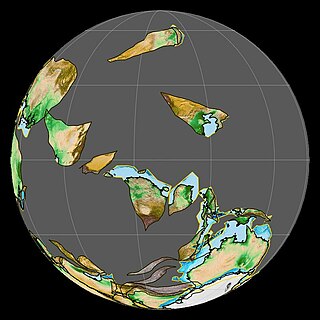
The geology of the Appalachians dates back more than 1.2 billion years to the Mesoproterozoic era when two continental cratons collided to form the supercontinent Rodinia, 500 million years prior to the development of the range during the formation of Pangea. The rocks exposed in today's Appalachian Mountains reveal elongate belts of folded and thrust faulted marine sedimentary rocks, volcanic rocks, and slivers of ancient ocean floor—strong evidences that these rocks were deformed during plate collision. The birth of the Appalachian ranges marks the first of several mountain building plate collisions that culminated in the construction of Pangea with the Appalachians and neighboring Anti-Atlas mountains near the center. These mountain ranges likely once reached elevations similar to those of the Alps and the Rocky Mountains before they were eroded.

The Acadian orogeny is a long-lasting mountain building event which began in the Middle Devonian, reaching a climax in the Late Devonian. It was active for approximately 50 million years, beginning roughly around 375 million years ago (Ma), with deformational, plutonic, and metamorphic events extending into the early Mississippian. The Acadian orogeny is the third of the four orogenies that formed the Appalachian Mountains and subsequent basin. The preceding orogenies consisted of the Grenville and Taconic orogenies, which followed a rift/drift stage in the Neoproterozoic. The Acadian orogeny involved the collision of a series of Avalonian continental fragments with the Laurasian continent. Geographically, the Acadian orogeny extended from the Canadian Maritime provinces migrating in a southwesterly direction toward Alabama. However, the northern Appalachian region, from New England northeastward into Gaspé region of Canada, was the most greatly affected region by the collision.

The Antler orogeny was a tectonic event that began in the early Late Devonian with widespread effects continuing into the Mississippian and early Pennsylvanian. Most of the evidence for this event is in Nevada but the limits of its reach are unknown. A great volume of conglomeratic deposits of mainly Mississippian age in Nevada and adjacent areas testifies to the existence of an important tectonic event, and implies nearby areas of uplift and erosion, but the nature and cause of that event are uncertain and in dispute. Although it is known as an orogeny, some of the classic features of orogeny as commonly defined such as metamorphism, and granitic intrusives have not been linked to it. In spite of this, the event is universally designated as an orogeny and that practice is continued here. This article outlines what is known and unknown about the Antler orogeny and describes three current theories regarding its nature and origin.
The Serpukhovian is in the ICS geologic timescale the uppermost stage or youngest age of the Mississippian, the lower subsystem of the Carboniferous. The Serpukhovian age lasted from 330.9 Ma to 323.2 Ma. It is preceded by the Visean and is followed by the Bashkirian. The Serpukhovian correlates with the lower part of the Namurian Stage of European stratigraphy and the middle and upper parts of the Chesterian Stage of North American stratigraphy.

The U.S. state of Georgia is commonly divided into four geologic regions that influence the location of the state's four traditional physiographic regions. The four geologic regions include the Appalachian foreland, Blue Ridge, Piedmont, and Coastal Plain. These four geologic regions commonly share names with and typically overlap the four physiographic regions of the state: the Appalachian Plateau and adjacent Valley and Ridge; the Blue Ridge; the Piedmont and the Coastal Plain.
The Conodont Alteration Index (CAI) is used to estimate the maximum temperature reached by a sedimentary rock using thermal alteration of conodont fossils. Conodonts in fossiliferous carbonates are prepared by dissolving the matrix with weak acid, since the conodonts are composed of apatite and thus do not dissolve as readily as carbonate. The fossils are then compared to the index under a microscope. The index was first developed by Anita Epstein and colleagues at the United States Geological Survey.

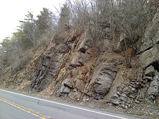
The Ordovician Martinsburg Formation (Om) is a mapped bedrock unit in Pennsylvania, New Jersey, Maryland, Virginia, and West Virginia. It is named for the town of Martinsburg, West Virginia for which it was first described. It is the dominant rock formation of the Great Appalachian Valley in New Jersey and Pennsylvania.

The Bend Arch–Fort Worth Basin Province is a major petroleum producing geological system which is primarily located in North Central Texas and southwestern Oklahoma. It is officially designated by the United States Geological Survey (USGS) as Province 045 and classified as the Barnett-Paleozoic Total Petroleum System (TPS).
The Devonian Mahantango Formation is a mapped bedrock unit in Pennsylvania, West Virginia, and Maryland. It is named for the North branch of the Mahantango Creek in Perry and Juniata counties in Pennsylvania. It is a member of the Hamilton Group, along with the underlying the Marcellus Formation Shale. South of Tuscarora Mountain in south central Pennsylvania, the lower members of this unit were also mapped as the Montebello Formation. Details of the type section and of stratigraphic nomenclature for this unit as used by the U.S. Geological Survey are available on-line at the National Geologic Map Database.
In petroleum geology, source rock is rock which has generated hydrocarbons or which could generate hydrocarbons. Source rocks are one of the necessary elements of a working petroleum system. They are organic-rich sediments that may have been deposited in a variety of environments including deep water marine, lacustrine and deltaic. Oil shale can be regarded as an organic-rich but immature source rock from which little or no oil has been generated and expelled. Subsurface source rock mapping methodologies make it possible to identify likely zones of petroleum occurrence in sedimentary basins as well as shale gas plays.
The Ordovician Kittatinny Formation or Kittatinny Limestone is a dolomitic limestone formation in New Jersey. The Kittatinny Limestones are located primarily in the Kittatinny Valley where it lies above the Ordovician Martinsburg Formation within the long valley running from Picatinny Arsenal in Rockaway Township, southwest toward Chester Township. It overlies the Cambrian Hardyston Quartzite.

The New Albany Shale is an organic-rich geologic formation of Devonian and Mississippian age in the Illinois Basin of the United States. It is a major source of hydrocarbons.
The Late Silurian to Early Devonian Keyser Formation is a mapped limestone bedrock unit in Pennsylvania, Maryland, Virginia, and West Virginia.

The Jordan Formation is a siliciclastic sedimentary rock unit identified in Illinois, Michigan, Wisconsin, Minnesota, and Iowa. Named for distinctive outcrops in the Minnesota River Valley near the town of Jordan, it extends throughout the Iowa Shelf and eastward over the Wisconsin Arch and Lincoln anticline into the Michigan Basin.

The Famatinian orogeny is an orogeny that predates the rise of the Andes and that took place in what is now western South America during the Paleozoic, leading to the formation of the Famatinian orogen also known as the Famatinian belt. The Famatinian orogeny lasted from the Late Cambrian to at least the Late Devonian and possibly the Early Carboniferous, with orogenic activity peaking about 490 to 460 million years ago. The orogeny involved metamorphism and deformation in the crust and the eruption and intrusion of magma along a Famatinian magmatic arc that formed a chain of volcanoes. The igneous rocks of the Famatinian magmatic arc are of calc-alkaline character and include gabbros, tonalites, granodiorites and trondhjemites. The youngest igneous rocks of the arc are granites.
The Mansfield Natural Gas Field is located west of Mansfield, Ohio, within the Appalachian foreland basin. The field is 1.5 miles (2.4 km) long by 1.4 miles (2.3 km) wide and is in a general oval shape, stretching northward. This field, although small, is an analog for many of the natural gas fields that occur within the Appalachian Basin. It was first discovered by the Pan American Petroleum and Transport Company in the early 1930s. It is part of the Utica – Lower Paleozoic system, which is estimated to make up 15 to 20 percent of the total hydrocarbon abundance of the Appalachian Basin.

The Arctic Alaska-Chukotka terrane (AAC) is a microcontinent that today encompasses the North Slope, Brooks Range, and Seward Peninsula of northern Alaska; the Chukotka Peninsula, New Siberia Islands, and Wrangel Island in eastern Siberia; and the continental shelves of the Bering, Beaufort, and Chukchi seas. Comparable in size to Greenland, the AAC is the largest of the Neoproterozoic–early Paleozoic continental fragments now dispersed around the Arctic Ocean; some of which possibly formed the continent Arctida.

The geology of South Korea includes rocks dating to the Archean and two large massifs of metamorphic rock as the crystalline basement, overlain by thick sedimentary sequences, younger metamorphic rocks and volcanic deposits. Despite the country's small size, its geology is diverse, containing rocks formed during the Precambrian to Cenozoic eras.
The geology of Venezuela includes ancient Precambrian igneous and metamorphic basement rocks, layered with sedimentary rocks from the Paleozoic and Mesozoic and thick geologically recent Cenozoic sediments with extensive oil and gas.

The geology of Peru includes ancient Proterozoic rocks, Paleozoic and Mesozoic volcanic and sedimentary rocks, and numerous basins and the Andes Mountains formed in the Cenozoic.
References
- 1 2 McPhee, John A. (1983). In suspect terrain. Internet Archive. New York : Farrar, Straus, Giroux. ISBN 978-0-374-17650-1.
- ↑ Parents' names, occupations, and birthplaces from the 1930 and 1940 United States Federal Censuses, via Ancestry.
- 1 2 3 Fey, David (Spring 2015). "Anita G. Harris (obituary)" (PDF). The Geological Division Retirees Newsletter (70): 13–14.
- ↑ Epstein, Anita Gloria Fishman. "Stratigraphy of Uppermost Silurian and Lowermost Devonian Rocks and the Conodont Fauna of the Coeymans Formation and its Correlatives in Northeastern Pennsylvania, New Jersey, and Southeasternmost New York" (Ph.D. dissertation, The Ohio State University, 1970); via ProQuest.
- ↑ Page, William R.; Lundstrom, Scott C.; Harris, Anita G.; Langenheim, Victoria E.; Workman, Jeremiah B.; Mahan, Shannon; Paces, James B.; Dixon, Gary L.; Rowley, Peter D.; Burchfiel, B. C.; Bell, John W.; Smith, Eugene I. (2005). "Geologic and geophysical maps of the Las Vegas 30' x 60' quadrangle, Clark and Nye counties, Nevada, and Inyo County, California". Scientific Investigations Map. doi:10.3133/sim2814. ISSN 2329-132X.
- ↑ First Eastern Gas Shales Symposium: Proceedings : October 17-19, 1977, Lakeview Inn and Country Club, Morgantown, West Virginia. U.S. Department of Energy, Technical Information Center. 1978. p. 756.
- ↑ Tiede, Tom (1977-10-30). "Geologist Finds Oil Clues in Fossils". The Daily Times. p. 4. Retrieved 2024-06-14– via Newspapers.com.
- ↑ Sward, Robert (1983-09-03). "Indiana Diamonds came from Canada". The Toronto Star. p. 80. Retrieved 2024-06-14– via Newspapers.com.
- ↑ McPhee, John (2000-06-15). Annals of the Former World. Farrar, Straus and Giroux. ISBN 978-0-374-70846-7.
- 1 2 "Anita Harris" Museum of the Earth, Paleontological Research Institution.
- 1 2 Epstein, Jack B., Anita G. Epstein, and S. M. Bergström. "Significance of Lower Ordovician exotic blocks in the Hamburg klippe, eastern Pennsylvania." Geological Survey Research (1972): D29-D36.
- 1 2 Harris, Anita G. "Conodont color alteration, an organo-mineral metamorphic index, and its application to Appalachian basin geology" SEPM Special Publication 26(1979): 3-16.
- 1 2 Harris, Leonard D.; Harris, Anita G.; DeWitt, Wallace Jr.; Bayer, Kenneth C. (1981). "Evaluation of Southern Eastern Overthrust Belt Beneath Blue Ridge-Piedmont Thrust". AAPG Bulletin. 65. doi:10.1306/03B599EF-16D1-11D7-8645000102C1865D. ISSN 0149-1423.
- 1 2 Wardlaw, Bruce R., and Anita G. Harris. "Conodont-based thermal maturation of Paleozoic rocks in Arizona." AAPG bulletin 68, no. 9 (1984): 1101-1106.
- 1 2 Rejebian, Vivian A., Anita G. Harris, and J. Stephen Huebner. "Conodont color and textural alteration: An index to regional metamorphism, contact metamorphism, and hydrothermal alteration." Geological Society of America Bulletin 99, no. 4 (1987): 471-479.
- 1 2 Pogue, Kevin R., Bruce R. Wardlaw, Anita G. Harris, and Ahmad Hussain. "Paleozoic and Mesozoic stratigraphy of the Peshawar basin, Pakistan: Correlations and implications." Geological Society of America Bulletin 104, no. 8 (1992): 915-927.
- 1 2 Page, William R., Anita G. Harris, Forrest G. Poole, and John E. Repetski. "Reinterpretation of the stratigraphy and structure of the Rancho Las Norias area, central Sonora, Mexico." Journal of South American Earth Sciences 16, no. 6 (2003): 523-540.
- 1 2 Dumoulin, Julie A., Anita G. Harris, Charles D. Blome, and Lorne E. Young. "Depositional settings, correlation, and age of Carboniferous rocks in the western Brooks Range, Alaska" Economic Geology 99, no. 7 (2004): 1355-1384.
- ↑ Epstein, Jack Burton; Epstein, Anita G. (1972). The Shawangunk Formation (Upper Ordovician(?) to Middle Silurian) in eastern Pennsylvania (Report). U.S Government Printing Office.
- ↑ Bergström, Stig M., Anita G. Epstein, and Jack B. Epstein. "Early Ordovician North Atlantic province conodonts in eastern Pennsylvania." Geological Survey Professional Paper 800 (1972): 37.
- ↑ Epstein, Anita G.; Epstein, Jack Burton; Harris, Leonard Dorreen (1977). Conodont color alteration: An index to organic metamorphism (Report). United States Government Printing Office. doi:10.3133/pp995.
- ↑ Harris, A. G.; Harris, L. D.; Epstein, J. B. (1978-01-01). Oil and gas data from Paleozoic rocks in the Appalachian Basin: maps for assessing hydrocarbon potential and thermal maturity (conodont color-alteration isograds and overburden isopachs) (Report). Geological Survey, Washington, DC (USA). OSTI 6079253.
- ↑ Harris, Anita G.; Sweet, Walter C. (January 1989). "Mechanical and chemical techniques for separating microfossils from rock, sediment and residue matrix". The Paleontological Society Special Publications. 4: 70–86. doi:10.1017/S2475262200005013. ISSN 2475-2622.
- ↑ Dumoulin, Julie A.; Harris, Anita G. (1994). Depositional Framework and Regional Correlation of Pre-Carboniferous Metacarbonate Rocks of the Snowden Mountain Area, Central Brooks Range, Northern Alaska. U.S. Department of the Interior, U.S. Geological Survey.
- ↑ Harris, Anita G., Julie A. Dumoulin, John E. Repetski, and Claire Carter. "Correlation of Ordovician rocks of northern Alaska" Ordovician Odyssey: Short Papers for the Seventh International Symposium on the Ordovician System (1995): 21-26.
- ↑ Repetski, John E., Robert T. Ryder, David J. Weary, Anita G. Harris, and Michael H. Trippi. "Thermal maturity patterns (CAI and% Ro) in Upper Ordovician and Devonian rocks of the Appalachian basin: A major revision of USGS Map I-917-E using new subsurface collections." US Geological Survey Scientific Investigations Map 3006 (2008): 26.
- ↑ Dumoulin, Julie A.; Harris, Anita G.; Repetski, John E. (2014), "Carbonate rocks of the Seward Peninsula, Alaska: Their correlation and paleogeographic significance", Reconstruction of a Late Proterozoic to Devonian Continental Margin Sequence, Northern Alaska, Its Paleogeographic Significance, and Contained Base-Metal Sulfide Deposits, Geological Society of America, doi:10.1130/2014.2506(03), ISBN 978-0-8137-2506-2 , retrieved 2024-06-14
- ↑ Orndorff, Randall C., David J. Weary, and Peter T. Lyttle. "Memorial to Jack B. Epstein" Geological Society of America Memorials 49(October 2020): 51-53.
- ↑ Epstein, Jack (November 2015). "Abstract: Anita Harris and a Black Conodont: A Personal Remembrance and Tribute". GSA Annual Meeting in Baltimore, Maryland, USA (1-4 November 2015). Retrieved 2024-06-14.
- ↑ Saucier, Heather (2015-05-01). "Anita Harris: Color Her World, With Love". AAPG Explorer. Retrieved 2024-06-14.
| International | |
|---|---|
| National | |