The Aniwhenua power station is a hydroelectric power facility in Bay of Plenty in New Zealand located on the Rangitaiki River upstream of the Matahina Power Station. Water is drawn from behind a dam above the Aniwhenua Falls and diverted through a canal and a headpond to the power station before being discharged back into the river. The power station is named after the falls which are adjacent to the power station.
In the late 19th century and early 20th century, numerous small local power generation stations were built by both private and local authorities. From the 1920s onward as the state electricity system expanded and the national grid was developed, development of small local power stations declined as the centralisation of electricity supply under state control increased.
The 1973–74 oil shock, nation-wide electricity shortages during the winters of 1973 and 1974, a renewed policy emphasis on regional development by central government, and increased uncertainty as to future wholesale electricity price trends lead to the New Zealand government to re-evaluate its policy regarding local hydro development. As a result, in 1977 the government announced that they would subsidize local power station schemes of less than 50 MW by providing grants to cover the investigation and design work, cheap loans to finance construction as well as loans from the NZED to cover operating losses in the early years of approved schemes. The government established the Committee on Local Authority Hydro Development (CLAHD) to evaluate applications for grants or loans from supply authorities.[1]
Taking up this opportunity the Bay of Plenty Electric Power Board which had begun operations in 1928 and engaged consultants to investigate a local hydro scheme in mid-1973. Preparation of a feasibility report was authorised in December 1973, with the report being completed in September 1974. The study determined that a power station on the Rangitaiki River at its confluence with the Pokairoa Stream, midway between Murupara and Whakatane. The scheme was technically feasible and financially viable. The main identified environmental impacts were significantly reduced flows over the Aniwhenua Falls, inundation of productive farm land and the displacement of one family, as well as the long term accumulation of sediment in the lake that the project would create. The issue of the reduced flow was managed by the imposing of a minimum residual flow over the falls.[2]
Following the obtaining of water rights, government consent and other necessary approval, construction and equipment supply contracts were let in the second half of 1977.
The civil works which commenced by the end of 1977 constructed by Downer and Company which involved the excavation of one million tons of material and the placing of 270,000 cubic metres of fill, 20,000 cubic metres of concrete and 884 tonnes of reinforcing steel.[3]
Commissioning
Aniwhenua began generating on 3 October 1980.[1] The 1982 annual report for the board showed that the total cost of the station to 31 March 1982 was $27,767,203 of which $24,628,809 was financed by government loan.[1] The book value of the scheme as at 31 March 1992 was $21,109,000. By the 1985/86 financial year, the scheme was breaking even financially and was able to trade its way into long-run profit without any write-offs of debt. Over the period from 1989 to 1992 as its trading activities were making a loss the profits from Aniwhenua kept the power board in the black.[1]
Service
The Energy Companies Act was enacted in 1992, and amended later that year. This act required the corporatisation of the electricity and gas undertakings of electric power boards and municipalities with the aim of ensuring a commercial and efficient approach to electricity distribution and supply.[4][1]
As a result, the power board was forced in August 1994 to vest all of its assets including Aniwhenua and associated water rights to the Bay of Plenty Electricity Limited.[5] Bay of Plenty Electricity subsequently became the first electricity company to be listed on the New Zealand stock exchange.
Purchase by Nova Energy
In July 1998 the New Zealand Government passed the Electricity Industry Reform Act which was intended to change the structure of the electricity industry to encourage competition. This Act required the operational separation of distribution and generation business activities by 1 July 1999 and separation of the ownership by 1 January 2004.[4]
As a result, in 1998 Bay of Plenty Electricity sold its retail and generation business, together with its name to Nova Energy, which was owned by the Todd Corporation.[6] On 1 April 1999, the remaining distribution assets were transferred to a new company, Horizon Energy Distribution Limited (which operates these assets under the name of Horizon Networks).
Leak
After a serious leak developed in the dam during Nova's ownership. Following investigations and development of a solution by consultants Tonkin + Taylor, the contracting firm of Waiotahi Contractors commenced in February 2006 the 58 day repair of the leak which took 58 day at a cost NZ$2.78 million.[7][8]
Purchase by Southern Generation Partnership
Looking to raise capital to invest in other energy projects in the North Island Nova agreed to sell Aniwhenua in November 2015 to Southern Generation Partnership (a partnership between Pioneer Generation Investments and Roaring Forties) for approximately NZ$100 million with ownership transferring in April 2016.[9][10] The Roaring Forties is a partnership between The Power Company and Electricity Invercargill.
At the beginning of December 2018 Pioneer Energy took over the services agreement with the Southern Generation Partnership to operate and maintain the power station.[6]
Design
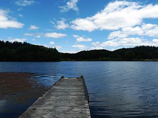
Lake Aniwhenua, the lake created by the dam.
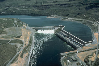
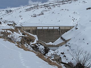
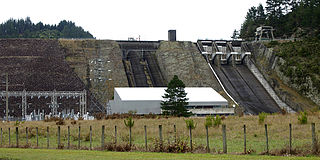
A 200-metre-long, 10-metre-high dam located upstream of the eight-metre-high Aniwhenua Falls[2] impounds the Rangitaiki River and Pokairoa Stream at their confluence at Black Road, Galatea, approximately 65km upstream from the river mouth to create Lake Aniwhenua. Smaller dams also divert water from the Pokairoa into Lake Aniwhenua. The lake is 4.5km long by approximately 500 m wide and is 255 ha in area. The maximum depth of the lake is 10 metres at the dam but it is typically less than three metres deep in other locations. The dam contains two wheeled penstock intake closure gates, two radial spillway gates which can discharge 1,270 cumecs of water. As well there are three additional flap type flood gates designed to handle higher flood conditions.[11]
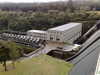
From the dam a 2.2km long concrete-lined canal conveys water to the Pahekeheke Headpond, which was created by damming the Pahekeheke Stream.[11] From the headpond two penstocks transport the water down to a powerhouse containing two Escher Wyss vertical Francis turbines which are each directly coupled to an ASEA 11 kV 12.5 MW synchronous generator.[11] The station produces on average 127 GWh per annum.[6] The output from the generating units is discharged back to the river just below the falls. The generator size was based on the desire to meet the power board's load factor of 65%.[2]
Compensation water of a 2.5 cumecs is also released from the dam to preserve the original river channel and maintain flow over the falls.[12] A small turbine coupled to a 100kW generator is driven by the compensation flow and supplies power to the local distribution network via Horizon Energy's Galatea feeder.[13]
Compensation water is also released from the headpond through a draw off pipe into the original course of the Pahekeheke Stream.
Via two 11/33/110 kV tertiary wound step-up transformers Aniwhenua is the primary supplier of electricity to Horizon Network's distribution network in the Galatea and Kaingaroa regions via a single 33 kV feeder that runs to Snake Hill and then splits into two feeders to supply Galatea with a further single feeder from Galatea to Kaingaroa.[13] Any surplus above this local demand is exported via a 110 kV circuit to the Matahina Power Station where the two power stations combine to export electricity to the national grid via two 110 kV circuits to Transpower's Edgecumbe Substation.
Operation
For transmission pricing purposes a Prudent Discount Agreement exists for Aniwhenua that makes it part of the Edgecumbe GXP. Aniwhenua is operated to maximise injection into the Horizon network. If there is any generation in excess of local load, this is exported to the national grid. As a result, the power station is effectively embedded.[14]
Operation of the power station is covered by the requirements of five resource consents, with the principal consent expiring in September 2026. The lake level operates between a normal operating range of 146.1 to 146.8 metre RL (relative to the Moturiki datum) with the emergency spillway having a level of 148.6 metre RL.[15] The power station operates as a run of river scheme as the lake is small in terms of river flow. Low overnight demand allows refilling of the lake and drawdown to provide increased generation over the daytime peaks.[2] and
The power station typically generates at least 8 MW, as below this value it will be necessary to spill water which will impact on the river downstream.
There is an ongoing programme to transfer migrating elvers and eels both upstream and downstream from the lake, to maintain eel stocks.
Sedimentation
The headwaters of the Rangitaki River collect lightweight pumice sands and partly greywacke gravels which are deposited in the lake. During its first 15 years of operation the lake accumulated approximately 1.5 million m3 of sediment.[16] Loss of storage has been managed by constructing training banks to encourage the sediment to settle in the deeper areas of the lake as well as lowering of the lake and flushing during floods.[2]
In addition, it has been necessary to undertake limited dredging operations to remove sedimentation with 30,000 m3 removed in 2002.
↑ Duder, J. N. (11–14 September 1996). "Reservoir Sedimentation- Some Aspects of Reservoir Asset Management". The Reservoir as an Asset: Proceedings of the Ninth Conference of the British Dam Society. London: Thomas Tetford Publishing. pp.242–243. ISBN0-7277-2528-9.
Further reading
Martin, John E., ed. (1991). People, Power and Power Stations: Electric Power Generation in New Zealand 1880 – 1990. Wellington: Bridget Williams Books Ltd and Electricity Corporation of New Zealand. ISBN0-908912-16-1.
Pickens, G.A.; Leyland, B. W.; Duder, J. N. (March 1984). "The Aniwhenua Hydroelectric Scheme". Transactions of the Institution of Professional Engineers New Zealand: Civil Engineering Section. Vol.11. London: Thomas Tetford Publishing. pp.13–27. ISBN0-7277-2528-9. ISSN0111-9508.
Reilly, Helen (2008). Connecting the Country: New Zealand's National Grid 1886 - 2007. Wellington: Steele Roberts. pp.376 pages. ISBN978-1-877448-40-9.
Small hydro is the development of hydroelectric power on a scale suitable for local community and industry, or to contribute to distributed generation in a regional electricity grid. Exact definitions vary, but a "small hydro" project is less than 50 megawatts (MW), and can be further subdivide by scale into "mini" (<1MW), "micro" (<100 kW), "pico" (<10 kW). In contrast many hydroelectric projects are of enormous size, such as the generating plant at the Three Gorges Dam at 22,500 megawatts or the vast multiple projects of the Tennessee Valley Authority.
Hydroelectricity, or hydroelectric power, is electricity generated from hydropower. Hydropower supplies one sixth of the world's electricity, almost 4,500 TWh in 2020, which is more than all other renewable sources combined and also more than nuclear power. Hydropower can provide large amounts of low-carbon electricity on demand, making it a key element for creating secure and clean electricity supply systems. A hydroelectric power station that has a dam and reservoir is a flexible source, since the amount of electricity produced can be increased or decreased in seconds or minutes in response to varying electricity demand. Once a hydroelectric complex is constructed, it produces no direct waste, and almost always emits considerably less greenhouse gas than fossil fuel-powered energy plants. However, when constructed in lowland rainforest areas, where part of the forest is inundated, substantial amounts of greenhouse gases may be emitted.
The Waitaki River is a large braided river in the South Island of New Zealand. It drains the Mackenzie Basin and runs 209 kilometres (130 mi) south-east to enter the Pacific Ocean between Timaru and Oamaru on the east coast. It starts at the confluence of the Ōhau and Tekapo rivers, now at the head of the artificial Lake Benmore, these rivers being fed by three large glacial lakes, Pukaki, Tekapo, and Ōhau at the base of the Southern Alps. The Waitaki flows through Lake Benmore, Lake Aviemore and Lake Waitaki, these lakes being contained by hydroelectric dams, Benmore Dam, Aviemore Dam and Waitaki Dam. The Waitaki has several tributaries, notably the Ahuriri River and the Hakataramea River. It passes Kurow and Glenavy before entering the Pacific Ocean. The River lends its name the Waitaki District on the south side of the river bank.
Lake Mahinerangi is a lake formed when a dam was built on the Waipori River for hydroelectric generation. The lake is 35 kilometres (22 mi) to the west of Dunedin in New Zealand's South Island. Construction of the dam started in 1903 and since 1907, power has been produced.
The Rangitaiki River is the longest river in the Bay of Plenty region in New Zealand's North Island. It is 155 kilometres (96 mi) long, and rises inland from northern Hawkes Bay to the east of the Kaingaroa Forest. The Rangitaiki catchment covers an area of 3005 km2. It flows in a generally northeastward direction, passing through the town of Murupara and skirting close to the western edge of Te Urewera National Park before turning northwards, flowing past Edgecumbe and into the Bay of Plenty close to Thornton.
Manawa Energy limited is a New Zealand electricity generation company that offers bespoke electricity products to commercial and industrial customers across New Zealand. Manawa energy currently operate 26 power schemes from the Bay of Plenty in the north, to Otago in the south.
The Shoalhaven Scheme is a dual-purpose water supply and Pumped-storage Hydroelectricity scheme located on the South Coast region of New South Wales, Australia.
The Rubicon Hydroelectric Scheme is a small run-of-the-river hydroelectric scheme located on the Rubicon and Royston Rivers, north east of Melbourne, 40 km (25 mi) south-west of Alexandra, Victoria, Australia. The scheme commenced in 1922, and was the first state-owned hydroelectric scheme to generate electricity in mainland Australia, and among the first in the world to be remotely controlled. For the first ten years of its operation it supplied on average 16.9% of electricity generated by the State Electricity Commission of Victoria. It is now owned and operated by AGL Energy and contributes approximately 0.02% of Victoria's energy supply.
Run-of-river hydroelectricity (ROR) or run-of-the-river hydroelectricity is a type of hydroelectric generation plant whereby little or no water storage is provided. Run-of-the-river power plants may have no water storage at all or a limited amount of storage, in which case the storage reservoir is referred to as pondage. A plant without pondage is subject to seasonal river flows, so the plant will operate as an intermittent energy source. Conventional hydro uses reservoirs, which regulate water for flood control, dispatchable electrical power, and the provision of fresh water for agriculture.
Hydroelectric power in New Zealand has been a part of the country's energy system for over 100 years and continues to provide more than half of the country's electricity needs. Hydroelectricity is the primary source of renewable energy in New Zealand. Power is generated the most in the South Island and is used most in the North Island.
The Karāpiro Power Station is a hydroelectric power station at Karapiro on the Waikato River, in the North Island of New Zealand. The power station lies on Lake Karapiro, a major rowing regatta venue. Karāpiro is 30 kilometres (19 mi) south-east and upstream from the city of Hamilton and approx. 9 kilometres from Cambridge. It is the last of the eight hydroelectric power stations on the Waikato River.
Ātiamuri Power Station is a hydroelectric power station on the Waikato River, in the North Island of New Zealand. It is the third of eight hydroelectric power stations on the Waikato River. The station can easily be seen from State Highway 1 between Taupō and Tokoroa.
Whakamaru Power Station is a hydroelectric power station on the Waikato River, in the North Island of New Zealand. It is the fourth hydroelectric power station on the Waikato River.
Tumut Two Dam or Tumut Two is a major ungated concrete gravity dam across the upper reaches of the Tumut River in the Snowy Mountains of New South Wales, Australia. The dam's main purpose is for the generation of hydro-power and is one of the sixteen major dams that comprise the Snowy Mountains Scheme, a vast hydroelectricity and irrigation complex constructed in south-east Australia between 1949 and 1974 and now run by Snowy Hydro.
Guthega Dam is concrete gravity dam with an uncontrolled spillway across the Snowy River in the Snowy Mountains of New South Wales, Australia. The dam's main purpose is for the storage of water used in the generation of hydro-power. It is the first to be completed of the sixteen major dams of the Snowy Mountains Scheme, a vast hydroelectricity and irrigation complex constructed in south-east Australia between 1949 and 1974 and now run by Snowy Hydro.
The Pupu Hydro Power Scheme is a small hydroelectric power station near Tākaka in the Golden Bay region of the South Island of New Zealand. It opened in 1929 as the first power station in the region and was the first public electricity supply in Golden Bay. After closing in 1980 following damage to the generator, the power scheme was fully restored by the local Pupu Hydro Society and many volunteer groups over the course of seven years and re-opened in 1988, again supplying electricity to the national grid.
Lake Āniwaniwa is a small man-made lake on the Rangitaiki River, in the Bay of Plenty region of New Zealand. The lake is situated 13 km north of the town of Murupara, and about 16 km upstream of the Matahina Dam. The lake was created as a result of the construction of a 10 m high dam, part of the Aniwhenua hydroelectric scheme.
Lake Matahina is a reservoir in the Bay of Plenty region of New Zealand, located immediately south of the settlement of Te Mahoe and 50 km east of Rotorua. The lake was formed by the construction of the Matahina Power Station and its associated 86 m tall Matahina Dam on the Rangitaiki River, which was completed in 1967.
The Matahina power station is a hydroelectric power facility in Bay of Plenty in New Zealand on the Rangitaiki River downstream of the Aniwhenua Power Station. The river was dammed to form Lake Matahina from which water is drawn and diverted through the power station before being discharged back into the river. The Matahina dam is the largest earth embankment dam in the North Island of New Zealand.
This page is based on this Wikipedia article Text is available under the CC BY-SA 4.0 license; additional terms may apply. Images, videos and audio are available under their respective licenses.