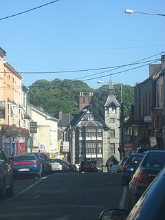
Mallow is a town in County Cork, Ireland, approximately thirty-five kilometres north of Cork. Mallow is in the barony of Fermoy.

Fota is an island in Cork Harbour, Ireland, just north of the larger island of Great Island. Fota Island is host to Ireland's only wildlife park – as well as the historical Fota House and gardens and golf course owned by the "Fota Island Golf Club and Resort". The island comprises two townlands both called Foaty: one each in the civil parishes of Clonmel and Carrigtohill.

Tower, Ordnance Survey Ireland name Model Village, is a village within the administrative area of Cork city in Ireland. It is located to the northwest of the city, approximately 3 km from the town of Blarney on the R617 road. Together with Blarney, Tower is a satellite or dormitory town of Cork city. Tower is part of the Cork North-Central.

Coolgarriv is a townland on the outskirts of Killarney, County Kerry, Ireland. It is located on Madam's Hill, overlooking Killarney in the nearby valley. It is bordered by Aghadoe and Knockasarnett townlands. Coolgarriv is part of Fossa parish, in the Diocese of Kerry.

Ardcarn or Ardcarne, is a civil parish in County Roscommon, Ireland.
Muckanaghederdauhaulia is a 470-acre townland in the civil parish of Kilcummin in County Galway, Ireland. It is in the poor law union of Oughterard in the barony of Moycullen.
Fermoy is a barony in County Cork in Ireland. It is bordered by the baronies of Orrery and Kilmore to the north-west; Duhallow to the west; Barretts to the south-west; Barrymore to the south; Condons and Clangibbon to the east; and Coshlea, County Limerick to the north. It is bounded to the south by the Nagle Mountains and the valley of the Munster Blackwater. The Ballyhoura Mountains mark the northern boundary. A tributary of the Blackwater, the Awbeg has two branches in its upper stretches; one branch forms the northern boundary while the other near Buttevant, forms the western limit. To the east, lies another Blackwater tributary, the Funcheon. Anomalously, the namesake town of Fermoy is actually in the barony of Condons and Clangibbon. The town with the greatest population in the barony is Mallow.

Aghavrin is a townland within both the civil parish and Catholic parish of Aghabullogue, County Cork, Ireland. It is 667.32 acres in size, situated south-west of Aghabullogue village, and north-west of Coachford village.

Carhoo Lower is a townland within the civil parish of Magourney and catholic parish of Aghabullogue, County Cork, Ireland. It is 284.5 acres in size, and west of Coachford village.
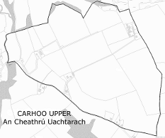
Carhoo Upper is a townland within the civil parish of Magourney and catholic parish of Aghabullogue, County Cork, Ireland. It is 199.08 acres in size, and west of Coachford village.

Rath is a civil parish in the barony of Inchiquin in County Clare, Ireland.

Carrignamuck is a townland within the civil parish of Magourney and catholic parish of Aghabullogue, County Cork, Ireland. It is 363.76 acres in size, situate north-east of Coachford village, and north-west of Dripsey village.
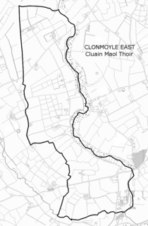
Clonmoyle East is a townland within both the civil parish and catholic parish of Aghabullogue, County Cork, Ireland. It is 756.05 acres in size, situate east of Aghabullogue village, and north of Coachford village.
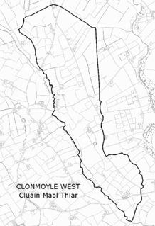
Clonmoyle West is a townland within both the civil parish and catholic parish of Aghabullogue, County Cork, Ireland. It is 774.06 acres in size, situate east of Aghabullogue village, and north-west of Coachford village.

Clontead Beg is a townland within the civil parish of Magourney and Catholic parish of Aghabullogue, County Cork, Ireland. It is approximately 229 acres in size, and east of Coachford village.

Corratillan is a townland in the civil parish of Templeport, County Cavan, Ireland. It lies in the Roman Catholic parish of Corlough and barony of Tullyhaw.
Knockmore is a townland in the civil parish of Templeport, County Cavan, Ireland. It lies in the Roman Catholic parish of Corlough and barony of Tullyhaw.
Gortnaderrylea is a townland in the civil parish of Kinawley, barony of Tullyhaw, County Cavan, Ireland.
Loumanagh, or Lamanaugh is a townland situated in west of Boherbue in north County Cork, Ireland, it is divided between Loumanagh North and Loumanagh South.
