
Annacloy River is a river in County Down, Northern Ireland, which goes through Dromara Hills and Strangford Lough. [1]
Annacloy River is a river in County Down, Northern Ireland, which goes through Dromara Hills and Strangford Lough. [1]
The Ballynahinch River, flowing east through Ballynahinch, and the Glasswater River, flowing south through Crossgar, join at Kilmore, and the united stream is called the Annacloy River, and lower down the River Quoile, falling into the southwest angle of Strangford Lough near Downpatrick. [2]
Between Annacloy to Stranford Lough, the Annacloy is renamed to the River Quoile. [3]

County Down is one of the six counties of Northern Ireland, one of the nine counties of Ulster and one of the traditional thirty-two counties of Ireland. It covers an area of 961 sq mi (2,490 km2) and has a population of 552,261. It borders County Antrim to the north, the Irish Sea to the east, County Armagh to the west, and County Louth across Carlingford Lough to the southwest.

Castle Espie is a wetland reserve managed by the Wildfowl and Wetlands Trust (WWT) on the banks of Strangford Lough, three miles south of Comber, County Down, Northern Ireland, in the townland of the same name. It is part of the Strangford Lough Ramsar Site. It provides an early wintering site for almost the entire Nearctic population of pale-bellied brent geese. The Castle which gave the reserve its name no longer exists.
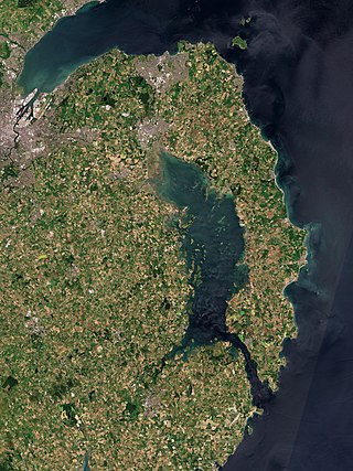
Strangford Lough is a large sea lough or inlet in County Down, in the east of Northern Ireland. It is the largest inlet in Ireland and the wider British Isles, covering 150 km2 (58 sq mi). The lough is almost fully enclosed by the Ards Peninsula and is linked to the Irish Sea by a long narrow channel at its southeastern edge. The main body of the lough has at least seventy islands along with many islets (pladdies), bays, coves, headlands and mudflats. It is part of the Strangford and Lecale Area of Outstanding Natural Beauty. Strangford Lough was designated as Northern Ireland's first Marine Conservation Zone in 2013, and has been designated a Special Area of Conservation for its important wildlife.
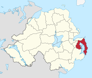
Ards was a local government district in Northern Ireland with the status of borough. It was one of twenty-six districts formed on 1 October 1973, and had its headquarters in Newtownards. It was merged with neighbouring North Down on 1 May 2015 to form the new Borough of Ards and North Down. Other towns in the defunct Borough included Portaferry, Comber, and Donaghadee, and the population of the area was 78,078 according to the 2011 census.

Down District Council was a Local Council in County Down in Northern Ireland. It merged with Newry and Mourne District Council in April 2015 under local government reorganisation in Northern Ireland to become Newry, Mourne and Down District Council.

Strangford is a parliamentary constituency in the United Kingdom House of Commons.
The Belfast and County Down Railway (BCDR) was an Irish gauge railway in Ireland linking Belfast with County Down. It was built in the 19th century and absorbed into the Ulster Transport Authority in 1948. All but the line between Belfast and Bangor was closed in the 1950s, although some of it has been restored near Downpatrick by a heritage line, the Downpatrick and County Down Railway.

The Quoile is a river in County Down, Northern Ireland.

Saul is a village in County Down, Northern Ireland, within the civil parish of Saul and Ballee.

Newry River, also known as the River Clanrye, is a river in Northern Ireland flowing through counties Down and Armagh. The river passes through the city of Newry and empties into Carlingford Lough near Warrenpoint.

Killinchy is a townland and small village in County Down, Northern Ireland. It is two miles inland from the western shores of Strangford Lough in the Borough of Ards and North Down. It is situated in the townland of the same name, the civil parish of Killinchy and the historic barony of Dufferin. It had a population of 539 people in the 2011 Census.

Quoile Castle is a castle situated 1.5 miles (2.4km) from Downpatrick, County Down, Northern Ireland, just off the main road from Downpatrick to Strangford, on the east bank of the River Quoile. The castle was built during the late 16th / early 17th Century and was continuously used up to the 1700s. It has been suggested that it was built by Captain Richard West. Quoile Castle is a State Care Historic Monument in the townland of Quoile, in Down District Council area, at grid ref: J4963 4701.
The Carryduff River is a minor river in County Down, Northern Ireland. It is a direct tributary of the River Lagan and is not navigable.

Ballynahinch River is a river in County Down, Northern Ireland. It is one of the two component watercourses which form the Annacloy River, also known as the Quoile River.
The A21, also Comber road, is a road in County Down in Northern Ireland. The route commences in Bangor, passing through Newtownards, Comber, and Ballygowan, and finishes on the northern outskirts of Ballynahinch.

Ringhaddy is a townland on the shores of Strangford Lough, County Down, Northern Ireland, 5 km south of Whiterock. It is in the civil parish of Killinchy and the historic barony of Dufferin.

Lecale is a peninsula in the east of County Down, Northern Ireland. It lies between Strangford Lough and Dundrum Bay. In the Middle Ages it was a district or túath in the Gaelic Irish kingdom of Ulaid, then became a county in the Anglo-Norman Earldom of Ulster. Later it became a barony, which was split into Lecale Lower and Lecale Upper by 1851. Its largest settlement is the town of Downpatrick. Other settlements include Ardglass, Killough and Strangford. The peninsula has a high concentration of tower houses. Much of it is part of the 'Strangford and Lecale' Area of Outstanding Natural Beauty.
Gores Island, also known as Gore's Island, is an island in Strangford Lough, County Down, Northern Ireland. It is connected to nearby Castle Island, and thence to the mainland, by a narrow roadway (doran) that is passable only at low tides. It has been inhabited previously, but has had no residents since 1910.

The Portaferry–Strangford ferry service crosses Strangford Lough in Northern Ireland at its narrowest point, close to where the lough joins the Irish Sea. The ferry links the two disconnected sections of the A2 road, Muff to Portaferry and Strangford to Newry. There has been a ferry service between Portaferry and Strangford for four centuries without a break. The alternative road journey is 47 miles (76 km), while the ferry crosses the 0.6 nautical miles in 8 minutes.