
Isidore of Seville was a Hispano-Roman scholar, theologian, and archbishop of Seville. He is widely regarded, in the words of 19th-century historian Montalembert, as "the last scholar of the ancient world".

The Carolingian Renaissance was the first of three medieval renaissances, a period of cultural activity in the Carolingian Empire. Charlemagne's reign led to an intellectual revival beginning in the 8th century and continuing throughout the 9th century, taking inspiration from ancient Roman and Greek culture and the Christian Roman Empire of the fourth century. During this period, there was an increase of literature, writing, visual arts, architecture, music, jurisprudence, liturgical reforms, and scriptural studies. Carolingian schools were effective centers of education, and they served generations of scholars by producing editions and copies of the classics, both Christian and pagan.

Etymologiae, also known as the Origines ('Origins'), usually abbreviated Orig., is an etymological encyclopedia compiled by the influential Christian bishop Isidore of Seville towards the end of his life. Isidore was encouraged to write the book by his friend Braulio, Bishop of Saragossa. Etymologiae summarized and organized a wealth of knowledge from hundreds of classical sources; three of its books are derived largely from Pliny the Elder's Natural History. Isidore acknowledges Pliny, but not his other principal sources, namely Cassiodorus, Servius, and Gaius Julius Solinus.
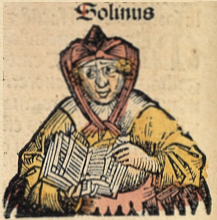
Gaius Julius Solinus, better known simply as Solinus, was a Latin grammarian, geographer, and compiler who probably flourished in the early 3rd century AD. Historical scholar Theodor Mommsen dates him to the middle of the 3rd century.
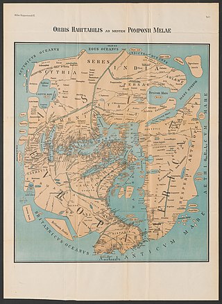
Pomponius Mela, who wrote around AD 43, was the earliest known Roman geographer. He was born in Tingentera and died c. AD 45.

Thule is the most northerly location mentioned in ancient Greek and Roman literature and cartography. Modern interpretations have included Orkney, Shetland, Northern Scotland, the island of Saaremaa (Ösel) in Estonia, and the Norwegian island of Smøla.

Gesta Hungarorum, or The Deeds of the Hungarians, is the earliest book about Hungarian history which has survived for posterity. Its genre is not chronicle, but gesta, meaning "deeds" or "acts", which is a medieval entertaining literature. It was written in Latin by an unidentified author who has traditionally been called Anonymus in scholarly works. According to most historians, the work was completed between around 1200 and 1230. The Gesta exists in a sole manuscript from the second part of the 13th century, which was for centuries held in Vienna. It is part of the collection of Széchényi National Library in Budapest.

A T and O map or O–T or T–O map, also known as an Isidoran map, is a type of early world map that represents world geography as first described by the 7th-century scholar Isidore of Seville (c. 560–636) in his De Natura Rerum and later his Etymologiae (c. 625)
Dicuilus was a monk and geographer, born during the second half of the 8th century. Noble and Evans identify him as a Gael and suggest that he had probably spent time in the Hebrides.

Glad was the ruler of Banat at the time of the Hungarian conquest of the Carpathian Basin around 900 AD, according to the Gesta Hungarorum. The Gesta, which was written by an author known in modern scholarship as Anonymus in the second half of the 12th century or in the early 13th century, is the earliest extant Hungarian chronicle. The Gesta did not refer to the enemies of the conquering Hungarians, who had been mentioned in earlier annals and chronicles, but wrote of a dozen persons, including Glad, who are unknown from other primary sources of the Hungarian Conquest. Therefore, modern historians debate whether Glad was an actual enemy of the conquerors or only a "fictitious person" made up by Anonymus. In Romanian historiography, based on the mention by Anonymus some 300 years later, Glad is described as one of the three Romanian dukes who ruled a historical region of present-day Romania in the early 10th century.
The Deciates (Δεκιήταις) were a Ligurian tribe dwelling near on the Mediterranean coast, around present-day Antibes, during the Iron Age and the Roman era.

The Geography, also known by its Latin names as the Geographia and the Cosmographia, is a gazetteer, an atlas, and a treatise on cartography, compiling the geographical knowledge of the 2nd-century Roman Empire. Originally written by Claudius Ptolemy in Greek at Alexandria around AD 150, the work was a revision of a now-lost atlas by Marinus of Tyre using additional Roman and Persian gazetteers and new principles. Its translation into Arabic in the 9th century was highly influential on the geographical knowledge and cartographic traditions of the Islamic world. Alongside the works of Islamic scholars – and the commentary containing revised and more accurate data by Alfraganus – Ptolemy's work was subsequently highly influential on Medieval and Renaissance Europe.

Polýaigos is an uninhabited Greek island in the Cyclades near Milos and Kimolos. It is part of the community of Kimolos. Its name means "many goats", since it is inhabited only by goats. It was mentioned by several ancient geographers: Ptolemy, Pliny the Elder, and Pomponius Mela.

Serica was one of the easternmost countries of Asia known to the Ancient Greek and Roman geographers. It is generally taken as referring to North China during its Zhou, Qin, and Han dynasties, as it was reached via the overland Silk Road in contrast to the Sinae, who were reached via the maritime routes. A similar distinction was later observed during the Middle Ages between "Cathay" (north) and "Mangi" or "China" (south). The people of Serica were the Seres, whose name was also used for their region. Access to Serica was eased following the Han conquest of the Tarim Basin but largely blocked when the Parthian Empire fell to the Sassanids. Henry Yule summarized the classical geographers:
If we fuse into one the ancient notices of the Seres and their country, omitting anomalous statements and manifest fables, the result will be something like the following:—"The region of the Seres is a vast and populous country, touching on the east the Ocean and the limits of the habitable world, and extending west to Imaus and the confines of Bactria. The people are civilized, mild, just, and frugal, eschewing collisions with their neighbours, and even shy of close intercourse, but not averse to dispose of their own products, of which raw silk is the staple, but which include also silk-stuffs, fine furs, and iron of remarkable quality." That is manifestly a definition of the Chinese.

In Greco-Roman geography, the Riphean Mountains were a supposed mountain range located in the far north of Eurasia. The name of the mountains is probably derived from Ancient Greek: ῥιπή. The Ripheans were often considered the northern boundary of the known world. As such, classical and medieval writers described them as extremely cold and covered in perennial snow. Ancient geographers considered the Ripheans the source of Boreas and several large rivers. The location of the Ripheans, as described by most classical geographers, would correspond roughly with the Volga region of modern-day Russia.
Crya or Krya was a city of ancient Lycia and was a polis (city-state) and a member of the Delian League.

Esmeraldo de Situ Orbis is an early modern work on cosmography and Atlantic exploration written by the Portuguese geographer and navigator Duarte Pacheco Pereira.

Pygela or Phygela (Φύγελα) was a small town of ancient Ionia, on the coast of the Caystrian Bay, a little to the south of Ephesus. It is located near Kuşadası, Asiatic Turkey. The ruins are right down on Pygela Plaji, "Pygela Beach." They are obviously partly drowned.
Natalia Lozovsky is a medievalist and translator, whose research focuses on science and geography in the medieval period. She has also demonstrated how ninth and tenth century works on geography, often draw on other literary traditions, such as exegesis. She also writes on how classical knowledge of geography was received by medieval Christian scholarship. She has worked on the lives and writings of Isidore of Seville, Dicuil, Ravenna Cosmographer and Orosius, amongst others.

Situs orbis terre vel regionum is an anonymous Latin geographical treatise written sometime between the late 7th and early 9th centuries. It was composed either in Septimania or the Iberian Peninsula, both part of the Visigothic Kingdom down to 711. It is known from a single manuscript, now in Paris, Bibliothèque nationale de France, MS lat. 4841, where it occupies the first thirteen folios. Certain features of the manuscript indicate that it was copied in Septimania in the Carolingian Empire around 842.