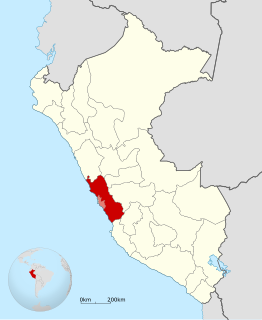
Huarochirí Province or Waruchiri is located in the Lima Region of Peru. Its capital is Matucana. The western section is part of the Lima Metropolitan Area.
The Yauli Province is one of the nine provinces in Peru that form the Junín Region. It is bordered to the north by the Pasco Region and the Junín Province, to the east by the Tarma Province, to the south by the Jauja Province and to the west by the Lima Region. The population of the province was estimated at 66,093 inhabitants in 2002. The capital of the Yauli Province is La Oroya.

The Yauyos Province is a province located in the Lima Region of Peru. It is one of the eleven that make up that region.
Huanza District is one of thirty-two districts of the province Huarochirí in Peru.

Coñocranra is a mountain of Peru located in the Ancash Region, Santa Province. It is the highest mountain in the Cordillera Negra at.

Antaqucha is a lake in Peru located in the Lima Region, Huarochirí Province, Huachupampa District. It is situated at a height of approximately 4,480 m (14,700 ft).
Anta Q'asa is a mountain in the Andes of Peru, about 5,000 metres (16,404 ft) high. It is situated in the Junín Region, Yauli Province, Marcapomacocha District, and in the Lima Region, Huarochirí Province, Chicla District. Anta Q'asa lies southwest of the mountain Pukaqucha, west of the mountains Yuraqqucha and Sillaqaqa, northeast of Llawa P'ukru and east of the mountain Quriqucha.
Sillaqaqa is a mountain in the Andes of Peru, about 5,000 metres (16,404 ft) high. It is situated in the Junín Region, Yauli Province, Marcapomacocha District, and in the Lima Region, Huarochirí Province, Chicla District. Sillaqaqa lies southwest of the mountain Pukaqucha, west of the mountain Yuraqqucha, northeast of Llawa P'ukru and east of the mountains Quriqucha and Anta Q'asa. The peak south of Sillaqaqa is named Inka Kancha.
Yuraqqucha is a mountain in the Andes of Peru, about 5,100 metres (16,732 ft) high. It is located in the Junín Region, Yauli Province, Morococha District, and in the Lima Region, Huarochirí Province, Chicla District. Yuraqqucha lies northwest of a lake named Waqraqucha, the Antikuna mountain pass and the peak of Antikuna. Anta Q'asa, Sillaqaqa, Inka Kancha and Pukaqucha are situated west, southwest and northwest of Yuraqqucha.

Puma Ranra is a mountain in the Andes of Peru, about 5,000 metres (16,404 ft) high. It is situated in the Arequipa Region, Castilla Province, Andagua District, and in the Condesuyos Province, Salamanca District. Puma Ranra lies southwest of Usqullu and Wakapallqa and Usqullu Lake, and northeast of the Coropuna volcano.
Yana Ranra is a mountain in the La Raya mountain range in the Andes of Peru, about 5,000 metres (16,404 ft) high. It is located in the Cusco Region, Canas Province, Layo District, and in the Canchis Province, Marangani District. Yana Ranra lies near the La Raya pass northwest of Chimpulla and Kunka and southwest of Huch'uy K'uchu. It is situated at the Hatun K'uchu valley whose stream flows to the Willkanuta River.
Yana Ranra is 5,002-metre-high (16,411 ft) mountain in the Wansu mountain range in the Andes of Peru. It is situated in the Apurímac Region, Antabamba Province, Antabamba District. Yana Ranra lies west of Paqu Qhawana, north of Quri Waraqa and south of Puka Urqu. South of Yana Ranra there is a small lake name Qiñwaqucha
Qunchupata is a mountain in the Andes of Peru, about 5,100 metres (16,732 ft) high. It is located in the Junín Region, Yauli Province, Marcapomacocha District, and in the Lima Region, Huarochirí Province, Chicla District. Qunchupata lies southwest of Anta Q'asa and Quriqucha and southeast of Yana Ulla. It is situated north of the Hatun Uqhu valley.
P'itiqucha is a lake in Peru located in the Lima Region, Huarochiri Province, Huanza District. P'itiqucha lies south of the Cordillera de la Corte surrounded by P'iti in the northeast, Anta Ranra in the south, Uyshu in the southwest and Saqsa in the northwest. It is situated southeast of Saqsaqucha.
Yana Yana is a 5,303-metre-high (17,398 ft) mountain in the Cordillera Central in the Andes of Peru. It is situated in the Lima Region, Huarochiri Province, on the border of the districts of Carampoma, Matucana and San Mateo, north of the Rimac River. Yana Yana lies southeast of Qarwa Ranra.
Qarwa Ranra is a mountain in the La Viuda mountain range in the Andes of Peru, about 5,000 metres (16,404 ft) high. It is situated in the Lima Region, Huarochirí Province, on the border of the districts of Carampoma and Matucana. It lies northwest of Yana Yana.
Puma Ranra is a mountain in the Cordillera Central in the Andes of Peru which reaches an altitude of approximately 5,200 m (17,100 ft). It is situated in the Lima Region, Yauyos Province, in the districts of Huantan and Laraos.
Anta P'unqu is a mountain in the Cordillera Central in the Andes of Peru which reaches a height of approximately 4,800 metres (15,748 ft). It is located in the Lima Region, Yauyos Province, Huantán District. Anta P'unqu lies northwest of Paquchi.