Anta province

Last updated
Anta
Tarahuasi Archaeological site - overview.jpg
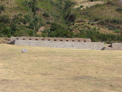
The archaeological site of Tarawasi in the province of Anta
Bandera anta.png
Location of the province Anta in Cusco.svg
Location of Anta in the Cusco Region
Country Peru
Region Cusco
Capital Anta
Government
  MayorWiliam Loaiza Ramos
Area
  Total
1,876.12 km2 (724.37 sq mi)
Population
(2005 census)
  Total
57,905
  Density31/km2 (80/sq mi)
UBIGEO 0803
Website www.anta.cus.mp.gob.pe

Anta is one of thirteen provinces in the Cusco Region in the southern highlands of Peru.

Contents

Geography

The Willkapampa mountain range traverses the province. The highest peak of the province is Sallqantay at 6,271 metres (20,574 ft). Other mountains are listed below: [1]

Political division

The province is divided into nine districts (Spanish : distritos, singular: distrito), each of which is headed by a mayor (alcalde). The districts, with their capitals in parentheses, are:

Ethnic groups

The people in the province are mainly indigenous citizens of Quechua descent. Quechua is the language which the majority of the population (70.28%) learnt to speak in childhood, 29.35% of the residents started speaking in Spanish. [2]

See also

Sources

  1. escale.minedu.gob.pe - UGEL map of the province of Anta (Cusco Region)
  2. inei.gob.pe Archived January 27, 2013, at the Wayback Machine INEI, Peru, Censos Nacionales 2007
Pampa de Anta.jpg
The pampa de Anta, a plateau, contains some of best communal cultivated lands in the provinces of Anta and Cusco. It is located at around 3000 meters above sea level, and is used to cultivate mainly high altitude crops such as potatoes, tarwi (edible lupin), barley and quinoa.

13°28′49″S72°06′40″W / 13.480167°S 72.111245°W / -13.480167; -72.111245