
The Apalachicola River is a river, approximately 160 miles (260 km) long, in the state of Florida. The river's large watershed, known as the Apalachicola, Chattahoochee and Flint (ACF) River Basin, drains an area of approximately 19,500 square miles (50,500 km2) into the Gulf of Mexico. The distance to its farthest head waters in northeast Georgia is approximately 500 miles (800 km). Its name comes from Apalachicola Province, an association of Native American towns located on what is now the Chattahoochee River. The Spanish included what is now called the Chattahoochee River as part of one river, calling all of it from its origins in the southern Appalachian foothills down to the Gulf of Mexico the Apalachicola.

The Piney Woods is a temperate coniferous forest terrestrial ecoregion in the Southern United States covering 54,400 square miles (141,000 km2) of East Texas, southern Arkansas, western Louisiana, and southeastern Oklahoma. These coniferous forests are dominated by several species of pine as well as hardwoods including hickory and oak. Historically the most dense part of this forest region was the Big Thicket though the lumber industry dramatically reduced the forest concentration in this area and throughout the Piney Woods during the 19th and 20th centuries. The World Wide Fund for Nature considers the Piney Woods to be one of the critically endangered ecoregions of the United States. The United States Environmental Protection Agency (EPA) defines most of this ecoregion as the South Central Plains.

The Ocala National Forest is the second largest nationally protected forest in the U.S. State of Florida. It covers 607 square miles (1,570 km2) of North Central Florida. It is located three miles (5 km) east of Ocala and 16 miles (26 km) southeast of Gainesville. The Ocala National Forest, established in 1908, is the oldest national forest east of the Mississippi River and the southernmost national forest in the continental U.S. The word Ocala is thought to be a derivative of a Timucuan term meaning "fair land" or "big hammock". The forest is headquartered in Tallahassee, as are all three National Forests in Florida, but there are local ranger district offices located in Silver Springs and Umatilla.

The Okefenokee National Wildlife Refuge is a 402,000‑acre (1,627 km2) National Wildlife Refuge located in Charlton, Ware, and Clinch Counties of Georgia, and Baker County in Florida, United States. The refuge is administered from offices in Folkston, Georgia. The refuge was established in 1937 to protect a majority of the 438,000 acre (1,772 km2) Okefenokee Swamp. Though often translated as "land of trembling earth", the name "Okefenokee" is likely derived from Hitchiti oki fanôːki "bubbling water".

The Florida Trail is one of eleven National Scenic Trails in the United States, created by the National Trails System Act of 1968. It runs 1,500 miles (2,400 km), from Big Cypress National Preserve to Fort Pickens at Gulf Islands National Seashore, Pensacola Beach. Also known as the Florida National Scenic Trail, the trail provides permanent non-motorized recreation for hiking and other compatible activities within an hour of most floridians.

The Lake George State Forest is a designated protected area and state forest in the U.S. state of Florida. The 21,176-acre (8,570 ha) forest is located in northwestern Volusia County, Florida, near Lake George and the communities of Pierson, Barberville, and Volusia. It is overseen by the Florida Forest Service within the Florida Department of Agriculture and Consumer Services.

The Florida Fish and Wildlife Conservation Commission (FWC) is a Florida government agency founded in 1999 and headquartered in Tallahassee. It manages and regulates the state's fish and wildlife resources, and enforces related laws. Officers are managers, researchers, and support personnel, and perform law enforcement in the course of their duties.

Colt Creek State Park is a Florida State Park in Central Florida, 16 miles (26 km) north of Lakeland off of State Road 471. This 5,067 acre park nestled within the Green Swamp Wilderness Area and named after one of the tributaries that flows through the property was opened to the public on January 20, 2007. Composed mainly of pine flatwoods, cypress domes and open pasture land, this piece of pristine wilderness is home to many animal species including the American bald eagle, Southern fox squirrel, gopher tortoise, white-tailed deer, wild turkey and bobcat.
Chassahowitzka Wildlife Management Area (WMA) preserves 24,243 acres of sandhill, mesic hammock, and forested wetland habitat ten miles north of Weeki Wachee in Hernando County, Florida. The area consists of one large tract of land, with three satellite tracts nearby.
Portneuf Wildlife Management Area at 3,104 acres (12.56 km2) is an Idaho Wildlife Management Area (WMA) in Bannock County near the town of McCammon. The first land acquisition for the WMA occurred in 1970 from M.S. Bastian, a local farmer and rancher. Three additional parcels were acquired in 1974.

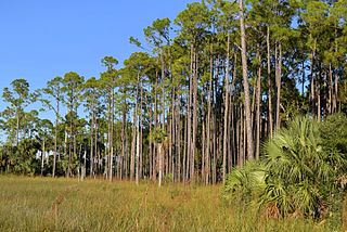
The Southeastern conifer forests are a temperate coniferous forest ecoregion of the southeastern United States. It is the largest conifer forest ecoregion east of the Mississippi River. It is also the southernmost instance of temperate coniferous forest within the Nearctic realm.
Andrews Wildlife Management Area is located on the Suwannee River, five miles north of Chiefland in Levy County, Florida.

Fred C. Babcock/Cecil M. Webb Wildlife Management Area (WMA) is Florida's oldest wildlife management area and protects 80,772 acres (32,687 ha) just southeast of Punta Gorda in Charlotte and Lee Counties, Florida. The area is accessed from its own exit off of Interstate-75.
Apalachicola River Wildlife and Environmental Area (ARWEA) contains 63,257 acres of pine upland, floodplain swamp, savanna, and estuary habitat north of Eastpoint and Apalachicola in Franklin County and Gulf County, Florida.
Okaloacoochee Slough Wildlife Management Area (WMA) protects 2,992 acres of the larger Okaloacoochee Slough ecosystem approximately 30 miles east of Fort Myers in Hendry County, Florida.
Escribano Point Wildlife Management Area (EPWMA) contains 4,057 acres of salt marsh, shrub bog, and sandhill habitat fourteen miles north of Pensacola in Santa Rosa County, Florida. In 2004, an initial 1,166 acres were acquired by the Florida Forever program and leased to the Florida Fish and Wildlife Conservation Commission to establish the EPWMA.
Suwannee Ridge Wildlife and Environmental Area (WEA) conserves 1,428 acres of longleaf pine uplands, karst topography and hardwood hammocks ten miles southwest of Jasper in Hamilton County, Florida.

Aucilla Wildlife Management Area conserves 50,549 acres of hydric hammock, mesic flatwoods, upland forest, and spring-run river twelve miles southeast of Tallahassee in Jefferson and Taylor Counties in Florida.

Mattaponi Wildlife Management Area is a 2,542-acre (10.29 km2) Wildlife Management Area (WMA) in Caroline County, Virginia. Located west of Bowling Green, the area protects a mixture of wetlands and upland forests at the confluence of the Mattaponi and South rivers.
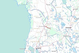
The Little Withlacoochee River is a 16-mile long river with its headwaters starting in the Richloam Wildlife Management Area in Sumter County, Florida. The Little Withlacoochee River ends near River Junction Campground just east of Silver Lake in the Croom Wildlife Management Area. It makes up a portion of the Hernando-Sumter County border. Its drainage basin covers 145 mi2 (376 km2) of Hernando County and Sumter County.
