Lower Saxony is a German state in northwestern Germany. It is the second-largest state by land area, with 47,614 km2 (18,384 sq mi), and fourth-largest in population among the 16 Länder federated as the Federal Republic of Germany. In rural areas, Northern Low Saxon and Saterland Frisian are still spoken, albeit in declining numbers.
Friesland is a district (Landkreis) in Lower Saxony, Germany. It is bounded by the districts of Wesermarsch, Ammerland, Leer and Wittmund, and by the North Sea. The city of Wilhelmshaven is enclosed by—but not part of—the district.
Leer is a district (Landkreis) in Lower Saxony, Germany. It is bounded by the city of Emden, the districts of Aurich, Wittmund, Friesland, Ammerland, Cloppenburg and Emsland, and by the Netherlands.
Ammerland is a district in Lower Saxony, Germany. It is bounded by the city of Oldenburg and the districts of Oldenburg, Cloppenburg, Leer, Friesland and Wesermarsch.
Wesermarsch is a Kreis (district) in the northwestern part of Lower Saxony, Germany. Neighboring are the districts of Cuxhaven and Osterholz, the city of Bremen in the state Free Hanseatic City of Bremen, the urban district of Delmenhorst, the district of Oldenburg and the urban district of Oldenburg, and the districts of Ammerland and Friesland.

Rotenburg an der Wümme is a town in Lower Saxony, Germany. It is the capital of the district of Rotenburg.
The district of Oldenburg is a district in the state of Lower Saxony, Germany. It is bounded by the districts of Diepholz, Vechta, Cloppenburg and Ammerland, the city of Oldenburg, the district of Wesermarsch and the city of Delmenhorst.
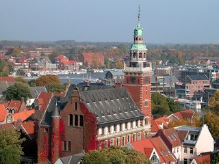
Leer is a town in the district of Leer, in the northwestern part of Lower Saxony, Germany. It is situated on the river Leda, a tributary of the river Ems, near the border with the Netherlands. With 34,958 inhabitants (2021), it is the third-largest city in East Frisia after Emden and Aurich.

Nordenham is a town in the Wesermarsch district, in Lower Saxony, Germany. It is located at the mouth of the Weser river on the Butjadingen peninsula on the coast of the North Sea. The seaport city of Bremerhaven is located on the other side of the river. The Midgard-seaport in Nordenham is the largest private-owned harbor in Germany.

Saterland is a municipality in the district of Cloppenburg, in Lower Saxony, Germany. It is situated between the cities of Leer, Cloppenburg, and Oldenburg. It is home to Saterland Frisians, who speak Frisian in addition to German.
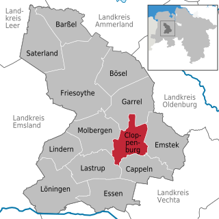
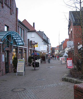
Cloppenburg is a town in Lower Saxony, Germany, capital of Cloppenburg District and part of Oldenburg Münsterland. It lies 38 km south-south-west of Oldenburg in the Weser-Ems region between Bremen and the Dutch border. Cloppenburg is not far from the A1, the major motorway connecting the Ruhr area to Bremen and Hamburg. Another major road is the federal highway B213 being the shortest link from the Netherlands to the A1 and thus to Bremen and Hamburg.
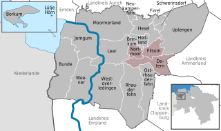
Jümme is a collective municipality (Samtgemeinde) in the district of Leer in the German state of Lower Saxony. It is named after the River Jümme which flows through all three constituent communities. It has an area of 82.34 km² and a population of 6,421. It is situated in the region of East Frisia. Along with the Samtgemeinde of Hesel, it is one of two in the district. It was formed in the wake of local government reform in 1973. Filsum serves as the administrative centre.

Wangerooge is one of the 32 Frisian Islands in the North Sea located close to the coasts of the Netherlands, Germany and Denmark. It is also a municipality in the district of Friesland in Lower Saxony in Germany.

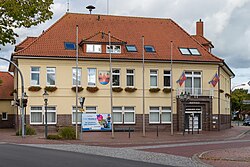
Westerstede is the capital of the Ammerland district, in Lower Saxony, Germany. It is situated approximately 25 km northwest of Oldenburg.

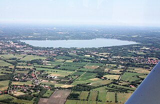
Bad Zwischenahn is a town and a municipality in the low-lying Ammerland district, in Lower Saxony, Germany. It is on Zwischenahner Meer, approximately 15 km northwest of Oldenburg and about 70 km south of the North Sea coast.

Rastede is a municipality in the Ammerland district, in Lower Saxony, Germany. It is situated approximately 12 km north of Oldenburg. It is the site of the Schloss Rastede.

Wiefelstede is a municipality in the Ammerland district, in Lower Saxony, Germany. It is situated approximately 15 km northwest of Oldenburg.
Varel is a town in the district of Friesland, in Lower Saxony, Germany. It is situated near the Jade River and the Jade Bight, approximately 15 kilometres (9.3 mi) south of Wilhelmshaven and 30 kilometres (19 mi) north of Oldenburg. With a population of 23,984 (2020) it is the biggest town in the district of Friesland.

Visbek is a municipality in the district of Vechta, in the Oldenburg Münsterland region of the state of Lower Saxony, Germany.

Spiekeroog is one of the East Frisian Islands, off the North Sea coast of Germany. It is situated between Langeoog to its west, and Wangerooge to its east. The island belongs to the district of Wittmund, in Lower Saxony in Germany. The only village on the island is also called Spiekeroog. The island is part of the Wadden Sea World Heritage Site by the UNESCO and the Lower Saxon Wadden Sea National Park.