
Locris was a region of ancient Greece, the homeland of the Locrians, made up of three distinct districts.

Continental Greece, colloquially known as Roúmeli (Ρούμελη), is a traditional geographic region of Greece. In English the area is usually called Central Greece, but the equivalent Greek term is more rarely used.
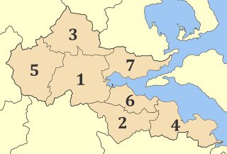
Phthiotis is one of the regional units of Greece. It is part of the administrative region of Central Greece. The capital is the city of Lamia. It is bordered by the Malian Gulf to the east, Boeotia in the south, Phocis in the south, Aetolia-Acarnania in the southwest, Evrytania in the west, Karditsa regional unit in the north, Larissa regional unit in the north, and Magnesia in the northeast. The name dates back to ancient times. It is best known as the home of Achilles.

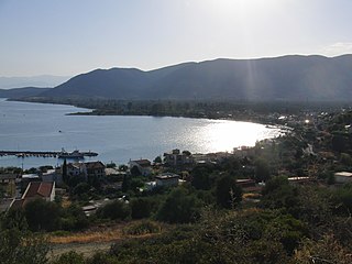
Itea, is a town and a former municipality in the southeastern part of Phocis, Greece. Since 2011 local government reforms made the city a part of the municipality Delphi, of which it is a municipal unit.

Doris is a small mountainous district in ancient Greece, bounded by Aetolia, southern Thessaly, the Ozolian Locrians, and Phocis; the original homeland of the Dorian Greeks. It lies between Mounts Oeta and Parnassus, and consists of the valley of the river Pindus (Πίνδος), a tributary of the Cephissus, into which it flows not far from the sources of the latter. The Pindus is now called the Apostoliá. This valley is open towards Phocis; but it lies higher than the valley of the Cephissus, rising above the towns of Drymaea, Tithronium, and Amphicaea, which are the last towns in Phocis.

Kallieis is a former municipality in the northern part of Phocis, Greece. Since the 2011 local government reform it is part of the municipality Delphi, of which it is a municipal unit. The municipal unit has an area of 183.256 km2. Its registered population in 2011 amounted to 1,673. The seat of the municipality was Mavrolithari, which is home to about 20% of the municipal unit population.
Kastellia is a village in the municipal unit of Gravia, Phocis, Greece. It is situated at the western end of the wide Cephissus valley, at the foot of the mountains Giona and Oeta. It is 3 km northwest of Gravia, 19 km north of Amfissa and 23 km south of Lamia. The Greek National Road 27 passes southeast of the village. The railway from Athens to Thessaloniki passes east of the village, with the nearest railway station at Bralos, 4 km east.
Erateini is a village in the southern part of Phocis, Greece. It was the municipal seat of the municipality of Tolofon. Erateini is situated on the Gulf of Corinth, 14 km west of Galaxidi, 19 km south of Lidoriki, 23 km southwest of Amfissa and 35 km east of Nafpaktos. The Greek National Road 48 passes through the village. In 2011, Erateini had a population of 856.
Kallithea is a village and a community in the municipal unit of Tolofon, southern Phocis, Greece. The community consists of the villages Kallithea, Agia Eirini, Agios Nikolaos, Agios Spyridonas, Klovinos, Flampourakia and the uninhabited islands Agios Nikolaos and Prasoudi. Kallithea is situated in the mountains near the coast of the Gulf of Corinth. The two largest villages, Agios Nikolaos and Agios Spyridonas, are on the coast. Kallithea is 5 km northwest of Tolofon, 26 km southwest of Amfissa and 27 km east of Nafpaktos. The Greek National Road 48 passes along the coast. There is a ferry service from Agios Nikolaos to Aigio, Peloponnese.
Artotina is a mountain village in the municipal unit of Vardousia, northwestern Phocis, Greece. It is situated on the western slope of the Vardousia mountains, near the source of the river Evinos, at about 1200 m elevation. Artotina is located 12 km north of Pentagioi and 36 km northwest of Amfissa.
Pentagioi is a mountain village in the municipal unit of Vardousia, northwestern Phocis, Greece. In 2011 its population was 246.
Zorianos is a mountain village in the municipal unit of Vardousia, northwestern Phocis, Greece. It is situated on a forested mountainside near the border with Aetolia-Acarnania, 31 km west of Amfissa. In 2011, the population of the village was 153.
Kaloskopi is a mountain village in the municipal unit of Gravia, northeastern Phocis, Greece. It is situated in the northeastern foothills of Mount Giona, 8 km west of Kastellia and 19 km north of Amfissa. In 2011 its population was 358.
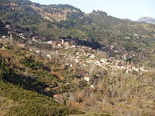
Athanasios Diakos is a small village in the municipal unit of Kallieis, Phocis, Greece. It was named after the Greek national hero Athanasios Diakos. He may have been born there as well, but this is disputed by the village Artotina. The village is situated on the eastern slope of the Vardousia mountains, above the upper valley of the river Mornos, at about 1000 m elevation. In 2011 its population was 518. It is the largest village in the municipal unit. It is 2 km northwest of Mousounitsa, 12 km east of Artotina and 26 km northwest of Amfissa.
Phthiotis and Phocis Prefecture was a prefecture of Greece. It was first established in 1833 as the Phocis and Locris Prefecture but abolished in 1836 and reconstituted in 1845 under its later name. At the time, it lay on the Greek-Ottoman border. With the annexation of Thessaly by Greece in 1881, the prefecture's territory came to include the Domokos Province. The prefecture was split up into separate Phthiotis and Phocis prefectures in the 1899 reform, but this was reverted in 1909. The prefecture finally ceased to exist in 1947, when it was again split up into Phthiotis and Phocis. These existed until the abolition of the prefectures in 2011, when they were transformed into regional units of the Central Greece region.

Eptalofos is a village and a community of the Delphi municipality. Before the 2011 local government reform it was a part of the municipality of Parnassos, of which it was a municipal district. The 2011 census recorded 461 residents in the village and 470 residents in the community. The community of Eptalofos covers an area of 32.796 km2.

Trizonia is a small island in Corinthian Gulf and the only inhabited island among the islands of Corinthian gulf. Along with the nearby islets Prasoudi, Planemi and Agios Ioannis comprise a small group of islands. It is located in the north coasts of Corinthian gulf opposite the villages Glyfada and Chania of Phocis prefecture. Its area is 2.5 square kilometers and its population is 64 inhabitants according to 2011 census. The island belongs to Dorida municipality in Phocis regional unit.


