Applewood, Mississauga

Last updated
Applewood
Suburban district
Aerial view of Applewood Mississauga 2022.jpg
Aerial view of Applewood
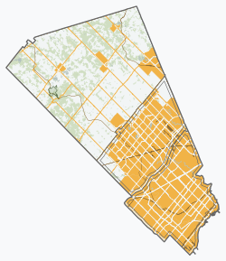
Peel locator map 2021.svg
Red pog.svg
Applewood
Location of Applewood in Mississauga
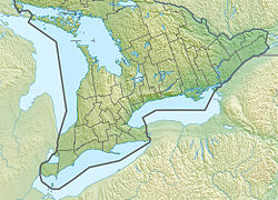
Canada Southern Ontario relief location map.jpg
Red pog.svg
Applewood
Location of Applewood in Southern Ontario
Coordinates: 43°34′N79°36′W / 43.567°N 79.600°W / 43.567; -79.600 [1]
Country Canada
Province Ontario
Regional Municipality Peel
City Mississauga
Established1955 (1955) as subdivision
Government
   MP Peter Fonseca (Mississauga East—Cooksville)
   MPP Kaleed Rasheed (Mississauga East—Cooksville)
   Councillors Chris Fonseca (Ward 3)
Population
 (2016) [2]
  Total36,000
Postal code FSA

Applewood is a suburban district consisting of a collection of neighbourhoods (each containing the district's name) in the city of Mississauga, Ontario, Canada. [1] It is bordered by Burnhamthorpe Road, Cawthra Road, the Queen Elizabeth Way, and the Etobicoke Creek. It is named for the apple orchards which predominated in the area prior to its development.

Contents

History

The earliest settlements in present-day Applewood occurred in the villages of Dixie and Burnhamthorpe which were established during the mid-1800s. The village of Dixie, centred at Dundas Street and Cawthra Road, was built in the early 1800s. The village of Burnhamthorpe was centred around the area of Burnhamthorpe Road and Dixie Road. These villages developed as local service centres for the immediate rural areas, which were characterized by farms and orchards. The cash crop of choice was apples. By the late 1800s, Dixie had an established market gardening centre. The first settlers of Applewood Acres included the Church, Haines, Graham, Stewart and Hedge families. Many Applewood streets are named after these early pioneer families. During the first half of the twentieth century, the villages of Dixie and Burnhamthorpe began to decline as a result of improved access to larger centers such as Port Credit and Cooksville. The Applewood District area remained predominantly rural to the mid-1950s when G.S. Shipp & Sons Ltd. began to develop the Applewood Heights subdivision on the former T.L. Kennedy farm at the corner of Dundas Street and Tomken Road in 1955. [3] A school, park, church and shopping mall were all constructed in the 1950s to provide service and amenities for the Applewood Acres families. Shipp & Son would build 733 houses in Applewood. [4] Around the same time, the Dixie Industrial Area south of Dundas Street was being promoted for industrial development. Today Applewood is an established residential community, providing a variety of housing types including single and semidetached dwellings, townhouses, apartments and mobile homes. [5] The Applewood district consists of the Applewood Acres community south of Queensway and Applewood Heights and Applewood Hills north of Dundas Street. These communities are separated by an industrial park.

Demographics

According to the Canada 2016 Census [lower-alpha 1] [6]

54% of population is immigrants. South Asians and Black make up the largest Visible Minority Groups.

Related Research Articles

<span class="mw-page-title-main">Mississauga</span> City in Ontario, Canada

Mississauga, historically known as Toronto Township, is a Canadian city in the province of Ontario, situated on the western shore of Lake Ontario in the Regional Municipality of Peel, adjoining the western border of Toronto. With a population of 717,961 as of 2021, Mississauga is the seventh-most populous municipality in Canada, third-most in Ontario, and second-most in the Greater Toronto Area (GTA) after Toronto itself. However, for the first time in its history, the city's population declined according to the 2021 census, from a 2016 population of 721,599 to 717,961, a 0.5 per cent decrease.

<span class="mw-page-title-main">Malton, Mississauga</span> Neighbourhood in Peel, Ontario, Canada

Malton is a neighbourhood in the northeastern part of the city of Mississauga, Ontario, Canada, located to the northwest of Toronto.

<span class="mw-page-title-main">Chinatowns in Toronto</span>

Toronto Chinatowns are ethnic enclaves in Toronto, Ontario, Canada, with a high concentration of ethnic Chinese residents and businesses. These neighbourhoods are major cultural, social and economic hubs for the Chinese-Canadian communities of the region. In addition to Toronto, several areas in the Greater Toronto Area also hold a high concentration of Chinese residents and businesses.

Martin Lyon Dobkin is a physician and former politician in Ontario, Canada. He was elected on October 1, 1973, as the first Mayor of the new City of Mississauga, Ontario, and served as Mayor from 1973 to 1976. He was the inaugural mayor of the newly amalgamated City of Mississauga, which had combined the former Towns of Mississauga, Port Credit and Streetsville. He lost re-election just three years later. He was originally trained as a medical doctor and he continued his practice during the time he was mayor. He continues to work as a doctor although a car accident in 2003 reduced his activities.

<span class="mw-page-title-main">Mississauga—Lakeshore (federal electoral district)</span> Federal electoral district in Ontario, Canada

Mississauga—Lakeshore is a federal electoral district in Peel Region, Ontario, Canada. It has been represented in the House of Commons of Canada since 1979.

<span class="mw-page-title-main">Mississauga—Brampton South</span> Federal electoral district in Ontario, Canada

Mississauga—Brampton South was a federal electoral district in Ontario, Canada, that was represented in the House of Commons of Canada from 2004 to 2015.

<span class="mw-page-title-main">Mississauga East—Cooksville (federal electoral district)</span> Federal electoral district in Ontario, Canada

Mississauga East—Cooksville is a federal electoral district in Ontario, Canada, that has been represented in the House of Commons of Canada since 2004.

<span class="mw-page-title-main">Cooksville, Mississauga</span> Neighbourhood in Peel, Ontario, Canada

Cooksville is a neighbourhood in Mississauga in the Greater Toronto Area region of Ontario, Canada. It is centred around the intersection of Dundas Street and Hurontario Street near the eponymous Cooksville Creek.

<span class="mw-page-title-main">Eatonville, Toronto</span> Neighbourhood in Toronto, Ontario, Canada

Eatonville is a neighbourhood in Toronto, Ontario, Canada. It is located west of the central core, in the former suburb of Etobicoke. Eatonville is bisected by Highway 427, with the community generally located north of Dundas Street West and south of Rathburn Road. Eatonville consists mainly of low density residential homes. The main arterial roads in the community, such as The West Mall, The East Mall and Burnhamthorpe Road, contain a mix of rental and condominium high-rise apartments and townhouses. Cloverdale Mall is in the neighbourhood, and there are community retail areas along Bloor Street West and Dundas Street West.

<span class="mw-page-title-main">Lakeview, Mississauga</span> Neighbourhood in Peel, Ontario, Canada

Lakeview is a neighbourhood in Mississauga in the Region of Peel, centred on Lakeshore Road in the extreme southeastern corner of the city, along the shore of Lake Ontario, between the larger neighbourhood of Port Credit to the west and the Long Branch neighbourhood of Toronto to the east.

<span class="mw-page-title-main">Dixie, Mississauga</span> Neighbourhood in Peel, Ontario, Canada

Dixie is a neighbourhood in the city of Mississauga, Ontario, Canada. The community lies in the southeastern part of the city and is one of the older neighbourhoods in the city.

<span class="mw-page-title-main">Harold Shipp</span> Canadian businessman (1926–2014)

Harold Gordon Shipp was a Canadian businessman, philanthropist and the chairman of Shipp Corporation Limited.

<span class="mw-page-title-main">Geography of Mississauga</span>

Mississauga is a city in the Canadian province of Ontario. It is a suburb of Toronto. The city is situated in the Regional Municipality of Peel and covers 288.42 square kilometres (111.36 sq mi) of land, fronting 13 kilometres (8.1 mi) of shoreline on Lake Ontario.

<span class="mw-page-title-main">Rockwood Village</span> Neighbourhood in Peel, Ontario, Canada

Rockwood Village is a neighbourhood in the eastern part of the City of Mississauga, Ontario, Canada, in the Regional Municipality of Peel. Its approximate boundaries are Eglinton Avenue in the north, Burnhamthorpe Road in the south, the Etobicoke Creek on the east and Dixie Road on the west. The Municipal Ward is Ward 3, the provincial riding is Mississauga East—Cooksville and the federal riding is Mississauga East—Cooksville. The Burnhamthorpe branch of the Mississauga Library System is located at the southwestern edge of Rockwood Village at the corner of Burnhamthorpe Road and Dixie Road.

<span class="mw-page-title-main">Cooksville Creek</span> River in Ontario, Canada

Cooksville Creek is a short stream in Mississauga, Regional Municipality of Peel in the Greater Toronto Area of Ontario, Canada. It begins near Bristol Road West and Hurontario Street and flows south to Lake Ontario at R.K McMilian Park near Lakeshore Road and Cawthra Road. The community of Cooksville is located on the west bank of the creek near Hurontario Street and Dundas Street East. The creek is surrounded mostly by residential homes and a few parks:

<span class="mw-page-title-main">Burnhamthorpe Road</span> Road in the Greater Toronto Area in Ontario, Canada

Burnhamthorpe Road is a major arterial road in the cities of Toronto and Mississauga, Ontario; beginning at Dundas Street, near Islington Avenue, running west and becoming a rural road in the Town of Oakville, where it terminates at Tremaine Road, where it changes name.

<span class="mw-page-title-main">Transportation in Mississauga</span>

The transport infrastructure and services in the Canadian city of Mississauga, Ontario include provincial highways and municipal roads, passenger and freight rail, regional and municipal bus service, and an international airport. It is interconnected with air, road, and rail transportation networks spanning the Greater Toronto Area and beyond.

<span class="mw-page-title-main">Mississauga—Lakeshore (provincial electoral district)</span> Provincial electoral district in Ontario, Canada

Mississauga—Lakeshore is a provincial electoral district in Ontario, Canada. It elects one member to the Legislative Assembly of Ontario. This riding was formerly known as Mississauga South prior to 2015.

<span class="mw-page-title-main">Mississauga City Centre</span> Downtown in Ontario, Canada

Mississauga City Centre is the downtown of Mississauga, Ontario, Canada. The downtown district is located generally at the intersection of Hurontario Street and Burnhamthorpe Road, centred around Square One Shopping Centre.

References

  1. 1 2 "Cooksville". Geographical Names Data Base . Natural Resources Canada . Retrieved 2014-04-17.
  2. "City of Mississauga - Population, Demographics & Housing" (PDF). mississauga.ca. September 2018. Archived (PDF) from the original on 14 February 2019. Retrieved 26 March 2021.
  3. "Dixie: Orchards to Industry. p. 184" (PDF). Hicks, Kathleen. Mississauga Library System. 2006. Retrieved May 14, 2021.
  4. "Still setting lofty goals after 67 years in business".
  5. Applewood Community Profile mississauga.ca February 2004
  6. "Neighbourhood Comparison Dashboard" . Retrieved 26 March 2021.
  1. The figures were calculated using Applewood NHD.