Dixie, Mississauga

Last updated
Dixie
Fountain Hill, Fonthill, Onion Town,
Irishtown, Cork Town, Sydenham
Neighbourhood
Dixie Aerial view 2022.jpg
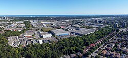
Aerial view of Dixie, Mississauga in 2022
Coordinates: 43°35′51″N79°36′5″W / 43.59750°N 79.60139°W / 43.59750; -79.60139
Country Canada
Province Ontario
Regional municipality Peel
City Mississauga
Time zone UTC-5 (Eastern)
  Summer (DST) UTC-4 (Eastern)
Forward sortation area
Area code(s) 905 and 289
NTS Map030M12
GNBC CodeFAWWY

Dixie is a neighbourhood in the city of Mississauga, Ontario, Canada. The community lies in the southeastern part of the city and is one of the older neighbourhoods in the city.

The name of the neighbourhood dates back to the Village of Dixie at the corner of Cawthra Road and Dundas Street West in the south part of the city. In 1865, the village of Sydenham was renamed in honour of Beaumont Wilson Bowen Dixie (1819-1898), [1] a Welsh settler who paid for the establishment of the Union Chapel, a multi-denominal Protestant church in the village originally built in 1816 (and rebuilt in 1837). [2] The church is also home to St. John's Dixie Union Cemetery, an active cemetery since 1816. The Chapel was built from donations from the Cody family of Buffalo Bill fame and was where his son was baptized in 1847.

Today, much of the area is commercial or industrial use with a small area of residential homes east of Dixie Road.

Related Research Articles

<span class="mw-page-title-main">Malton, Mississauga</span> Neighbourhood in Peel, Ontario, Canada

Malton is a neighbourhood in the northeastern part of the city of Mississauga, Ontario, Canada, located to the northwest of Toronto.

<span class="mw-page-title-main">Chinatowns in Toronto</span>

Toronto Chinatowns are ethnic enclaves in Toronto, Ontario, Canada, with a high concentration of ethnic Chinese residents and businesses. These neighbourhoods are major cultural, social and economic hubs for the Chinese-Canadian communities of the region. In addition to Toronto, several areas in the Greater Toronto Area also hold a high concentration of Chinese residents and businesses.

<span class="mw-page-title-main">Hoggs Hollow</span> Neighbourhood in Toronto, Ontario, Canada

Hoggs Hollow is a residential neighbourhood in North York, Toronto, Ontario, Canada. It is located in the Don River Valley and centred on the intersection of Yonge Street, York Mills Road, and Wilson Avenue.

<span class="mw-page-title-main">Port Credit</span> Neighbourhood in Peel, Ontario, Canada

Port Credit is a neighbourhood in the south-central part of the City of Mississauga, Ontario, Canada, located at the mouth of the Credit River on the north shore of Lake Ontario. Its main intersection is Hurontario Street and Lakeshore Road, about 0.6 kilometres (0.37 mi) east of the river. Until 1974, Port Credit was an incorporated town. Its approximate boundaries are the Canadian National Railway to the north, Seneca Avenue to the east and Shawnmarr Road to the west. It had a population of 10,260 at the 2001 census.

<span class="mw-page-title-main">Streetsville, Mississauga</span> Neighbourhood in Peel, Ontario, Canada

Streetsville is a neighbourhood located in the northwestern corner of the city of Mississauga, Ontario, Canada, on the Credit River. Although Streetsville occupies the west and east banks of the river, the majority is located on the west bank of the river.

<span class="mw-page-title-main">Streetsville GO Station</span> Railway station in Mississauga, Ontario, Canada

Streetsville GO Station is a GO Transit railway station on the Milton line in the Greater Toronto Area, Ontario, Canada. It is located in the community of Streetsville in Mississauga.

<span class="mw-page-title-main">Clarkson, Mississauga</span> Neighbourhood in Peel, Ontario, Canada

Clarkson, also called Clarkson Village, is a neighbourhood in the city of Mississauga, Ontario, Canada, situated in the southwest corner of the city, along the shore of Lake Ontario. It is bordered by Lake Ontario to the south, Oakville to the west, Erindale and Erin Mills to the north, and Lorne Park to the east.

<span class="mw-page-title-main">Mississauga East—Cooksville</span> Federal electoral district in Ontario, Canada

Mississauga East—Cooksville is a federal electoral district in Ontario, Canada, that has been represented in the House of Commons of Canada since 2004.

<span class="mw-page-title-main">Meadowvale, Mississauga</span> Suburban district in Peel, Ontario, Canada

Meadowvale is a large suburban district located in the northwestern part of Mississauga, Ontario, Canada, just west of Toronto. In the 19th and early 20th centuries, Meadowvale Village in Toronto Township was established nearby and named for the meadows along the Credit River. By the 1970s the village would diminish with the current area to the west selected to be the site of a "new town" for the newly (1974) incorporated City of Mississauga and took the Meadowvale name, while "Village" was added to the historic community. This newer section comprises the bulk of the district today, and includes Lisgar, another former hamlet of which no trace remains today.

<span class="mw-page-title-main">Lorne Park</span> Neighbourhood in Peel, Ontario, Canada

Lorne Park is a suburban residential neighbourhood located in southwestern Mississauga, Ontario, Canada, that was first established as a resort.

<span class="mw-page-title-main">Adamson Estate</span>

The Adamson Estate, which forms the eastern boundary of the Port Credit neighbourhood of Mississauga, Ontario, was purchased from the family of Agar Adamson by Credit Valley Conservation Authority in 1975 upon the urging of the local ratepayers group known as Project H21 after a proposed real estate development which would have changed the character of the neighbourhood. It is now a public park on the Waterfront Trail. It was recognized as a Historic Place in 1978.

<span class="mw-page-title-main">Claireville, Toronto</span> Place in Ontario, Canada

Claireville is a neighbourhood and former hamlet in the city of Toronto, Ontario, Canada. It is located in the northwest corner of Toronto, in the former city of Etobicoke. Today Claireville is almost wholly industrial/commercial.

<span class="mw-page-title-main">Islington-City Centre West</span> Neighbourhood in Toronto, Ontario, Canada

Islington-City Centre West is a commercial and residential neighbourhood in Etobicoke, Toronto, Ontario, Canada. One of four central business districts outside Downtown Toronto, it is bounded by Rathburn Road to the north, Islington Avenue to the east, Bloor Street to the south, Mimico Creek to the west.

Don Valley Village Neighbourhood in Toronto, Ontario, Canada

Don Valley Village is a neighbourhood in the city of Toronto, Ontario, Canada. It is located in the former suburb of North York. Located north of Highway 401 and bisected by Don Mills Road, it is bounded by Sheppard Avenue to the south, Leslie Street to the west, Finch Avenue to the north and Highway 404 to the east. Like the nearby Don River Valley, the neighbourhood has hill and dale topography.

<span class="mw-page-title-main">Toronto Gore Township, Ontario</span>

Toronto Gore is a former incorporated and now geographic township in Ontario, Canada. It is today split between Mississauga and Brampton.

Vinegar Hill is an unincorporated community in Markham, Ontario, Canada bounded by Highway 7 to the north, Highway 407 to the south, and streets just west and east of Main Street South, bordered by the Rouge River. The name of the community is believed to be linked to a cider mill on the east side of the river valley or barrel makers that filled them with vinegar to test their straightness when rolling down Markham Road.

<span class="mw-page-title-main">Churchville, Brampton</span> Unincorporated community in Ontario, Canada

Churchville is a preserved suburban hamlet in the south-west corner of Brampton, Ontario, Canada. It is designated as a heritage community under the Ontario Heritage Act.

<span class="mw-page-title-main">Rockwood Village</span>

Rockwood Village is a neighbourhood in the eastern part of the City of Mississauga, Ontario, in the Regional Municipality of Peel. Its approximate boundaries are Eglinton Avenue in the north, Burnhamthorpe Road in the south, the Etobicoke Creek on the east and Dixie Road on the west. The Municipal Ward is Ward 3, the Provincial Riding is Mississauga—Brampton South and the Federal Riding is Mississauga—Brampton South. The Burnhamthorpe branch of the Mississauga Library System is located at the southwest corner of Burnhamthorpe and Dixie Roads.

<span class="mw-page-title-main">Southcoates</span> Area of Kingston upon Hull, East Riding of Yorkshire, England

Southcoates is an urban area in the eastern part of Kingston upon Hull, England.

<span class="mw-page-title-main">Applewood, Mississauga</span> Suburban district in Peel, Ontario, Canada

Applewood is a suburban district consisting of a collection of neighbourhoods in the city of Mississauga, Ontario, Canada. It is bordered by Burnhamthorpe Road, Cawthra Road, the Queen Elizabeth Way, and the Etobicoke Creek. It is named for the apple orchards which predominated in the area prior to its development.

References

  1. "Mississauga Historic images gallery".
  2. History and Heritage of Mississauga Archived July 25, 2008, at the Wayback Machine

Coordinates: 43°35′51″N79°36′05″W / 43.59750°N 79.60139°W / 43.59750; -79.60139