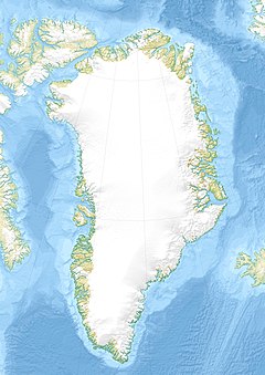
Greenland is located between the Arctic Ocean and the North Atlantic Ocean, northeast of Canada and northwest of Iceland. The territory comprises the island of Greenland—the largest island in the world—and more than a hundred other smaller islands. As an island, Greenland has no land boundaries and 44,087 km of coastline. A sparse population is confined to small settlements along certain sectors of the coast. Greenland possesses the world's second largest ice sheet.

Tasiilaq, formerly Ammassalik and Angmagssalik, is a town in the Sermersooq municipality in southeastern Greenland. With 2,017 inhabitants as of 2013, it is the most populous community on the eastern coast, and the seventh-largest town in Greenland. The Sermilik Station, dedicated to the research of the nearby Mittivakkat Glacier, is located near the town.

Kulusuk Airport is an airport in Kulusuk, a settlement on an island of the same name off the shore of the North Atlantic in the Sermersooq municipality in southeastern Greenland.

Kuummiit is a settlement in the Sermersooq municipality in southeastern Greenland. Founded in 1915, it had 331 inhabitants in 2013.

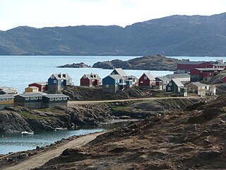
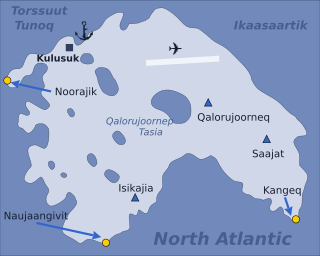
Kulusuk, formerly Kap Dan, is a settlement in the Sermersooq municipality in southeastern Greenland, located on an island of the same name. The settlement population of 267 includes many Danes choosing to live there due to the airport. In the Kalaallisut language, the name of the village means "Chest of a Black Guillemot".

Ikkatteq was a small village in the Sermersooq municipality in southeastern Greenland. It was abandoned in 2005.
Tourism in Greenland is a relatively young business area of the country. Since the foundation of the national tourist council, Greenland Tourism, in 1992, the Home Rule Government has been working actively with promoting the destination and helping smaller tourist providers establish their services. Foreign travel agencies have increasingly been opening up sale of Greenland trips and tours, and the cruise industry has had a relatively large increase in routes to Greenland since about the turn of the century.

Ammassalik Fjord is a 41 km (25.5 mi) long fjord in the Sermersooq municipality in southeastern Greenland.

Ammassalik Island is an island in the Sermersooq municipality in southeastern Greenland, with an area of 772 km2 (298.1 sq mi).

Tasiilaq Heliport or Ammassalik Heliport is a heliport in Tasiilaq, a town located on the Ammassalik Island in the Sermersooq municipality, in southeastern Greenland. Until 1997 the heliport was known as Ammassalik Heliport and is still listed by the Danish authorities under that name.

Isortoq Heliport is a heliport in Isortoq, a village in the Sermersooq municipality in southeastern Greenland. The heliport is considered a helistop, and is served by Air Greenland as part of a government contract.

Tiniteqilaaq Heliport is a heliport in Tiniteqilaaq, a village in the Sermersooq municipality in southeastern Greenland. The heliport is considered a helistop, and is served by Air Greenland as part of a government contract.

Sermiligaaq Heliport is a heliport in Sermiligaaq, a village in the Sermersooq municipality in southeastern Greenland. The heliport is considered a helistop, and is served by Air Greenland as part of a government contract.

Kulusuk Island is an island in the Sermersooq municipality on the southeastern shore of Greenland. It is an outlying island in the Ammassalik archipelago of islands on the coast of the North Atlantic. The island is home to Kulusuk, the fourth-largest settlement on the entire eastern coast of Greenland. The island has an area of 41.98 km², and measures 8 km (5.0 mi) from north to south and 11 km (6.8 mi) from west to east. The Kulusuk Airport on the island is one of the two airports on the entire eastern Greenland coast.

Apusiaajik Island is an uninhabited island in the Sermersooq municipality on the southeastern shore of Greenland. It is an outlying island in the Ammassalik archipelago of islands on the coast of the North Atlantic.

Torsuut Tunoq is a sound on the southeastern coast of Greenland. It is an inner waterway of the North Atlantic.

Ikaasaartik Strait is a strait in the Sermersooq municipality, on the southeastern coast of Greenland.

Sermilik is a fjord in eastern Greenland. It is part of the Sermersooq municipality.

Schweizerland, also known as Schweizerland Alps, is a mountain range in King Christian IX Land, eastern Greenland. Administratively this range is part of the Sermersooq Municipality. Its highest point is one of the highest peaks in Greenland.

Johan Petersen Fjord, also known as Petersen Bay, is a fjord in King Christian IX Land, Eastern Greenland. The fjord is named after Danish Arctic explorer Johan Petersen (1813–1880).


