
Ghardaïa is an Algerian province located in the north of the Algerian desert. Its administrative center is the city of Ghardaia, located 600 km (370 mi) south of the capital Algiers. Its total area is estimated at 21,224.03 km2 (8,194.64 sq mi), 138 km (86 mi) from north to south, and 200 to 250 km from east to west. It rises 486 m (1,594 ft) above sea level.

Laghouat is one of the fifty-eight provinces (wilaya) of Algeria. It is located in the north central part of Algeria. The province borders Tiaret Province to the north, El Bayadh Province to the west, Ghardaia Province to the south and Djelfa Province to the east. The capital of the province is Laghouat City. The province is famous for palm trees and livestock.
Reggane is a town and commune, and the capital of Reggane District, in Adrar Province, central Algeria. Reggane lies in the Sahara Desert near an oasis. According to the 2008 census it has a population of 20,402, up from 14,179 in 1998, with an annual growth rate of 3.8%. Berber tribes and people live in and around Reggane.

El Bayadh is a municipality of Algeria. It is the capital of El Bayadh Province.

Souk Ahras is a province (wilaya) in the Aures region in Algeria, named after its capital, Souk Ahras. It stands on the border between Algeria and Tunisia. In 2008, Souk Ahras had a population of 440,299 people.

In Guezzam is a town and commune that is the capital of In Guezzam Province, Algeria, on the border with Niger. Until 26 November 2019, it was a part of the Tamanrasset Province. The border town on the Niger side is Assamaka. According to the 2008 census it had a population of 7,045, up from 4,938 in 1998, with an annual growth rate of 3.7%, the second highest in the Tamanrasset province's 2008 boundaries.

Hassi Messaoud is a town in Ouargla Province, eastern Algeria, located 85 kilometres (53 mi) southeast of Ouargla. As of 2008 it had a population of 45,147 people, up from 40,360 in 1998, and an annual population growth rate of 1.1%, the lowest in the province. Oil was discovered there in 1956 and the town's prominence has grown rapidly since then; it is considered as the First Energy town in Algeria where all the big oil and gas companies have offices and bases. It is an oil refinery town named after the first oil well. A water well, dug in 1917, can be found on the airport side of town. Today there are over 800 wells within a 25 kilometres (16 mi) radius of the town.
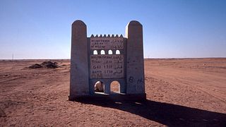
Tindouf is the main town, and a commune in Tindouf Province, Algeria, close to the Mauritanian, Western Saharan and Moroccan borders. The commune has a population of around 160,000, but the census and population estimates do not count the Sahrawi refugees, making the population as of the 2008 census 45,966, up from 25,266 in 1998, giving the town an annual population growth rate of 6.3%.

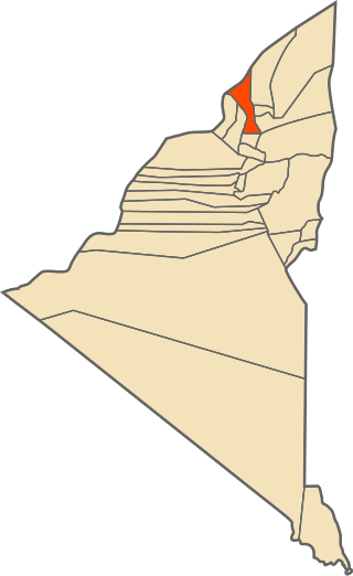
El Bayadh is a province (wilaya) in Algeria, named after its capital El Bayadh. It is surrounded by mountains from the South, North, and Northeast of the state.
Collo, known as Chullu in antiquity, is a port town in the Skikda Province in northeastern Algeria, and forms part of the Collo Massif region. It is the capital and one of three municipalities of the Collo District.
Ouled Aissa is a town and commune in Charouine District, Adrar Province, in south-central Algeria. According to the 2008 census it has a population of 7,034, up from 5,497 in 1998, with an annual growth rate of 2.5%.

Talmine is a town and commune in Charouine District, Adrar Province, in south-central Algeria. According to the 2008 census it has a population of 12,768, up from 9,469 in 1998, with an annual growth rate of 3.1%.

Metlili is a town and commune, and capital of Métlili District, in Ghardaïa Province, Algeria. According to the 2008 census it has a population of 40,576, up from 33,759 in 1998, and an annual growth rate of 1.9%.
Mouloudia Club El Bayadh, known as MC El Bayadh or simply MCEB for short, is an Algerian football club based in El Bayadh. The club was founded in 1936 and its colours are white and blue. Their home stadium, Zakaria Medjdoub Stadium, has a capacity of 15,000 spectators. The club is currently playing in the Algerian Ligue Professionnelle 1.
El Bayadh Airport (French: Aéroport d'El Bayadh is a public airport serving El Bayadh, the capital of El Bayadh Province, Algeria. It is located about 10 km northwest of the city. It is operated by Établissement de Gestion des Services Aéroportuaires d’Oran.

El Bnoud or Benoud is a town and commune in El Bayadh Province, Algeria, and is the southernmost commune in the province. It had a population of 1,607 in 2008.
Stitten is a town and commune in El Bayadh Province, Algeria.
Boualem is a town and commune in El Bayadh Province, Algeria. It is the district seat of Boualem District.
El Kheiter is a town and commune in El Bayadh Province, Algeria.

Bougtob is a town and commune in El Bayadh Province, Algeria. It is the district seat of Bougtob District.


