Archimedes Geo3D is a software package for dynamic geometry in three dimensions. It was released in Germany in March 2006 and won a German government award for outstanding educational software in 2007 .
Contents

Archimedes Geo3D is a software package for dynamic geometry in three dimensions. It was released in Germany in March 2006 and won a German government award for outstanding educational software in 2007 .
Archimedes Geo3D can trace the movement of points, lines, segments, and circles and generate locus lines and surfaces. Arbitrary objects can be intersected with lines, locus lines, and planes.

Archimedes of Syracuse was an Ancient Greek mathematician, physicist, engineer, astronomer, and inventor from the ancient city of Syracuse in Sicily. Although few details of his life are known, he is regarded as one of the leading scientists in classical antiquity. Considered the greatest mathematician of ancient history, and one of the greatest of all time, Archimedes anticipated modern calculus and analysis by applying the concept of the infinitely small and the method of exhaustion to derive and rigorously prove a range of geometrical theorems. These include the area of a circle, the surface area and volume of a sphere, the area of an ellipse, the area under a parabola, the volume of a segment of a paraboloid of revolution, the volume of a segment of a hyperboloid of revolution, and the area of a spiral.

Civil engineering is a professional engineering discipline that deals with the design, construction, and maintenance of the physical and naturally built environment, including public works such as roads, bridges, canals, dams, airports, sewage systems, pipelines, structural components of buildings, and railways.
An integrated development environment (IDE) is a software application that provides comprehensive facilities for software development. An IDE normally consists of at least a source-code editor, build automation tools, and a debugger. Some IDEs, such as IntelliJ IDEA, Eclipse and Lazarus contain the necessary compiler, interpreter or both; others, such as SharpDevelop and NetBeans, do not.

The Archimedes' screw, also known as the Archimedean screw, hydrodynamic screw, water screw or Egyptian screw, is one of the earliest hydraulic machines named after Greek mathematician Archimedes who first described it around 234 BC, although the device had been used in Ancient Egypt. It is a reversible hydraulic machine, and there are several examples of Archimedes screw installations where the screw can operate at different times as either pump or generator, depending on needs for power and watercourse flow.
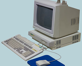
Acorn Archimedes is a series of personal computers designed by Acorn Computers in Cambridge, England, that were launched in 1987. These systems were powered by Acorn's own ARM architecture processors and ran on proprietary operating systems: Arthur and RISC OS. The Archimedes family was sold until the mid-1990s.

The Archimedes Palimpsest is a parchment codex palimpsest, originally a Byzantine Greek copy of a compilation of Archimedes and other authors. It contains two works of Archimedes that were thought to have been lost and the only surviving original Greek edition of his work On Floating Bodies. The first version of the compilation is believed to have been produced by Isidore of Miletus, the architect of the geometrically complex Hagia Sophia cathedral in Constantinople, sometime around AD 530. The copy found in the palimpsest was created from this original, also in Constantinople, during the Macedonian Renaissance, a time when mathematics in the capital was being revived by the former Greek Orthodox bishop of Thessaloniki Leo the Geometer, a cousin of the Patriarch.

Sibelius is a scorewriter program developed and released by Sibelius Software Limited. Beyond creating, editing and printing music scores, it can also play the music back using sampled or synthesised sounds. It produces printed scores, and can also publish them via the Internet for others to access. Less advanced versions of Sibelius at lower prices have been released, as have various add-ons for the software.

Pappus of Alexandria was a Greek mathematician of late antiquity known for his Synagoge (Συναγωγή) or Collection, and for Pappus's hexagon theorem in projective geometry. Almost nothing is known about his life except for what can be found in his own writings, many of which are lost. Pappus apparently lived in Alexandria, where he worked as a mathematics teacher to higher level students, such one named Hermodorus.

In mathematics, a semicircle is a one-dimensional locus of points that forms half of a circle. It is a circular arc that measures 180°. It only has one line of symmetry.
Xara is an international software company founded in 1981, with an HQ in Berlin and development office in Hemel Hempstead, UK. It has developed software for a variety of computer platforms, in chronological order: the Acorn Atom, BBC Micro, Z88, Atari ST, Acorn Archimedes, Microsoft Windows, Linux, and more recently web browser-based services.

GeoGebra is an interactive geometry, algebra, statistics and calculus application, intended for learning and teaching mathematics and science from primary school to university level. GeoGebra is available on multiple platforms, with apps for desktops, tablets and web. It is presently owned by Indian edutech firm Byju's.

Archimedes's cattle problem is a problem in Diophantine analysis, the study of polynomial equations with integer solutions. Attributed to Archimedes, the problem involves computing the number of cattle in a herd of the sun god from a given set of restrictions. The problem was discovered by Gotthold Ephraim Lessing in a Greek manuscript containing a poem of forty-four lines, in the Herzog August Library in Wolfenbüttel, Germany in 1773.

Archimedes – "The Open CAD" – is a computer-aided design (CAD) program developed with direct input from architects and architecture firms. The program was made to create software more compatible with architectural design than the currently widely used AutoCAD, and other available CAD softwares. The program is free software released under the Eclipse Public License.

The BBC Microcomputer System, or BBC Micro, is a series of microcomputers designed and built by Acorn Computers Limited in the 1980s for the Computer Literacy Project of the BBC. The machine was the focus of a number of educational BBC TV programmes on computer literacy, starting with The Computer Programme in 1982, followed by Making the Most of the Micro, Computers in Control in 1983, and finally Micro Live in 1985.
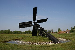
The tjasker is a small type of windmill used solely for drainage purposes. It is distinctive for its simple construction, featuring only a single inclined shaft that carries the sails on one end and an Archimedes' screw on the other, in this way avoiding the need for any gearing. The tjasker is commonly known as a typical Frisian windmill though it is also found in other Dutch provinces and in north Germany.

An ellipsograph is a mechanism that generates the shape of an ellipse. One common form of ellipsograph is known as the trammel of Archimedes. It consists of two shuttles which are confined to perpendicular channels or rails and a rod which is attached to the shuttles by pivots at adjustable positions along the rod.

Conqueror is a video game released as the follow-up to Zarch, using the same landscape engine. It is a third-person shooter with strategy elements in which the player controls a fleet of tanks. It was originally developed and released on the Acorn Archimedes by Superior Software in 1988 and ported to other home computers in 1990 by Rainbow Arts. The game was well received, particularly for its blend of strategy and arcade action.
Archimedes is a TCAD package for use by engineers to design and simulate submicron and mesoscopic semiconductor devices. Archimedes is free software and thus it can be copied, modified and redistributed under GPL. Archimedes uses the Ensemble Monte Carlo method and is able to simulate physics effects and transport for electrons and heavy holes in Silicon, Germanium, GaAs, InSb, AlSb, AlAs, AlxInxSb, AlxIn(1-x)Sb, AlP, AlSb, GaP, GaSb, InP and their compounds, along with Silicon Oxide. Applied and/or self-consistent electrostatic and magnetic fields are handled with the Poisson and Faraday equations.