Arad County is an administrative division (județ) of Romania roughly translated into county in the western part of the country on the border with Hungary, mostly in the region of Crișana and few villages in Banat. The administrative center of the county lies in the city of Arad. The Arad County is part of the Danube–Criș–Mureș–Tisa Euroregion.

Șiria is a commune in Arad County, Romania. According to the 2002 census it had 8,140 inhabitants.
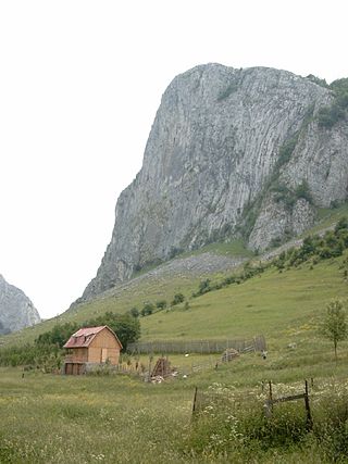
The Apuseni Mountains is a mountain range in Transylvania, Romania, which belongs to the Western Romanian Carpathians. The highest peak is the Bihor Peak at 1,849 metres (6,066 ft). The Apuseni Mountains have about 400 caves.
Sebiș is a town in Arad County, western Transylvania, Romania. Situated 82 km (51 mi) from the county capital, Sebiș is one of the most important urban centres in the Crișul Alb valley. It administers three villages: Donceni (Dancsfalva), Prunișor (Kertes), and Sălăjeni (Szelezsény).

Bârzava is a commune in Arad County, Romania. The commune Bârzava is situated at the foot of Zărand Mountains, at its contact point with Metaliferi Mountains, along the river Bârzava - a right tributary of the Mureș. It is composed of eight villages: Bârzava, Bătuța (Battuca), Căpruța (Kapruca), Dumbrăvița (Alsódombró), Groșii Noi (Garassa), Lalașinț (Lalánc), Monoroștia (Marosmonyoró) and Slatina de Mureș (Marosszlatina).

Cărand is a commune in Arad County, Romania. Cărand commune is situated in the northern part of the Sebiș Basin, at the foot of Codru-Moma Mountains and its surface is 3813 ha. It is composed of two villages, Cărand and Seliștea (Bélmárkaszék).

Conop is a commune located in Arad County, Romania. Conop is situated at the southern foot of Zărand Mountains, in the Mureș River Couloir. The commune stretches over 5,466 ha and it is composed of five villages: Belotinț (Belotinc), Chelmac (Maroseperjes), Conop, Milova (Milova), and Odvoș (Odvos).

Covăsânț is a commune in Arad County, Romania.

Moneasa is a commune in Arad County, Romania. Its administrative surface stretches over 6,824 hectares and it is composed of two villages, Moneasa and Rănușa (Kisróna).
The Codru-Moma Mountains are a part of the Apuseni Mountains. They are specifically located in the Arad and Bihor counties, within the Western Romanian Carpathians of Crișana, Romania.

Craiva is a commune in Arad County, Romania. The commune Craiva is situated in the contact zone of the Susag's high plateau with Mărăuș Hills and Codru-Moma Mountains, along the river Sartiș, having an administrative territory of 11,490 hectares. It is composed of ten villages: Chișlaca (Kislaka), Ciuntești (Csontaháza), Coroi (Bélkaroly), Craiva, Mărăuș (Bélnagymaros), Rogoz de Beliu (Bélrogoz), Stoinești (Bélkismaros), Susag (Pusztaszuszág), Șiad (Sajád) and Tălmaci (Bántolmács).

Ghioroc is a commune in Arad County, Romania. Ghioroc commune is situated in the contact zone of Zărand Mountains and Arad Plateau, on the Matca channel, and it stretches over 4,890 ha. It is composed of three villages: Cuvin (Aradkövi), Ghioroc and Miniș (Ménes).

Hășmaș is a commune in Arad County, Crișana, Romania.

Ignești is a commune in Arad County, Romania, is situated at the southern foot of Codru-Moma Mountains, in the Ineu-Gurahonț Basin. The commune stretches over 5192 hectares and is composed of four villages: Ignești, Minead (Menyéd), Nădălbești (Nádalmás) and Susani (Susányfalva).

Păuliș is a commune in Arad County, Romania, situated in the contact zone of the Mureș Couloir with the Arad Plateau and Zărand Mountains. The administrative territory of the commune is 12,806 hectares. The commune centre is situated at 25 km from Arad. It is composed of four villages: Barațca (Pálosbaracka), Cladova (Kalodva), Păuliș and Sâmbăteni (Szabadhely).

Pleșcuța, a commune in Arad County, Romania, is situated in the Hălmagiu Basin, at the foot of Codru-Moma Mountains and Metaliferi Mountains, along the upper course of the Crișul Alb River. It is connected with the Gurahonț Basin by the epigenetic defile of the Crișul Alb existing between Pleșcuța and Gurahonț. The commune stretches over 7000 hectares and is composed of seven villages: Aciuța (Acsuca), Budești (Bugyfalva), Dumbrava (Körösdombró), Gura Văii (Vojkaháza), Pleșcuța, Rostoci (Rosztócs) and Tălagiu (Talács).

Săvârșin is a commune in Arad County, Romania. Săvârșin commune lies at the foot of the Metaliferi Mountains, at its contact point with the Mureș Couloir. Its surface occupies approximately 22000 hectares and it is composed of nine villages: Căprioara (Kaprióra), Cuiaș (Felsőköves), Hălăliș (Áldásos), Pârnești (Pernyefalva), Săvârșin, Temeșești (Temesd), Toc (Tok), Troaș (Trojás) and Valea Mare (Marosnagyvölgy).

Vârfurile is a commune in Arad County, Romania. It lies on the north-western part of the Hălmagiu Basin, at the feet of Bihor and Codru-Moma Mountains. Its territory is 13600 ha. It is composed of eight villages: Avram Iancu (Ácsva), Groși (Halmágygóros), Lazuri (Irtványfalu), Măgulicea (Kismaglód), Mermești (Mermesd), Poiana (Csúcsmező), Vârfurile and Vidra.

Vărădia de Mureș is a commune in Arad County, Romania. It stretches over approximately 12600 hectares, situated in the contact zone of Metaliferi Mountains and Zărandului Mountains, respectively partially in the large valley of the Mureș River. It is composed of six villages: Baia (Kisbaja), Julița (Gyulatő), Lupești (Farkasháza), Nicolae Bălcescu (Alsóköves), Stejar (Szarvaság) and Vărădia de Mureș.

Tauț is a commune in Arad County, Romania. It is situated in the contact zone of the Cigherului Hills and Zărandului Mountains, in the hydrographical basin of the river Cigher. The administrative territory of the commune is 10,617 hectares. It is composed of four villages: Minișel, Minișu de Sus, Nadăș and Tauț.