Arad County is an administrative division (județ) of Romania roughly translated into county in the western part of the country on the border with Hungary, mostly in the region of Crișana and few villages in Banat. The administrative center of the county lies in the city of Arad. The Arad County is part of the Danube–Criș–Mureș–Tisa Euroregion.

Curtici is a town located in Arad County, in western Romania. The town is situated at a 17 km (11 mi) distance from the county capital, Arad, in the western part of Arad County. It is the most important railway meeting point of Central Europe with the western part of Romania. Its administrative territory extends on a 7,970 ha area, on the Sântana Plateau, a plateau characterized in the zone of the town by the sand hills formed by the old branches of the river Mureș.

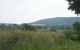
Șiria is a commune in Arad County, Romania. According to the 2002 census it had 8,140 inhabitants.
Almaș is a commune in Arad County, Romania. Situated in the Gurahonț Basin, in the left valley of the Crişul Alb River, the commune is composed of four villages: Almaș, Cil (Alcsil), Joia Mare (Kakaró) and Rădești (Bozósd). Its total administrative territory is 8127 ha.
Bârsa is a commune in Arad County, Romania. The commune is situated in the Sebiș Basin, on the left part of the Mills Ditch and it has an administrative territory of 5174 ha. It is composed of four villages: Aldești (Áldófalva), Bârsa, Hodiș (Zarándhódos) and Voivodeni (Körösvajda).

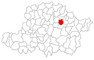
Bârzava is a commune in Arad County, Romania. The commune Bârzava is situated at the foot of Zărand Mountains, at its contact point with Metaliferi Mountains, along the river Bârzava - a right tributary of the Mureș. It is composed of eight villages: Bârzava, Bătuța (Battuca), Căpruța (Kapruca), Dumbrăvița (Alsódombró), Groșii Noi (Garassa), Lalașinț (Lalánc), Monoroștia (Marosmonyoró) and Slatina de Mureș (Marosszlatina).

Birchiș is a commune in Arad County, Romania.

Bocsig is a commune in Arad County, Romania. The commune is situated in the Ineu Basin, along the Crișul Alb River, and it stretches over 6,648 ha. It is composed of three villages: Bocsig, Mânerău (Monyoró) and Răpsig (Repszeg).

Șeitin is a commune in western Romania, located in the southwest part of Arad County, is situated in the south-western part of the Arad Plateau, in the valley of the river Mureș, and it covers approximately 6680 ha. The commune is composed of a single village, Șeitin, situated at 47 km from Arad.

Semlac is a commune located in Arad County, in the western part of Romania, near the border with Hungary, is situated in the south-western part of the Arad Plateau, in the large valley of the Mureș River. Its territory occupies 8,311 ha. It is composed of a single village, Semlac, situated 37 km (23 mi) from Arad.
Dorobanți is a commune in Arad County, Romania. Dorobanți commune lies in the Arad Plateau and it stretches over 2780 hectare. It is composed of a single village, Dorobanți, split off from Curtici town in 2004. It is situated at 25 km from Arad.
Iratoșu is a commune in Arad County, Romania, on the Arad Plateau, at the western border of Romania. The commune stretches over 3,770 hectares and is composed of three villages: Iratoșu, Variașu Mare (Nagyvarjas), and Variașu Mic (Kisvarjaspuszta).

Livada is a commune in Arad County, Romania. Livada commune is situated on the Arad Plateau, northward from Arad. The commune stretches over 2013 hectares and is composed of two villages, Livada and Sânleani (Szentleányfalva).

Peregu Mare is a commune in Arad County, Romania, on the Arad Plateau, at the western border of Romania. The commune stretches over 3095 ha and is composed of two villages, Peregu Mare and Peregu Mic (Kispereg).

Pilu is a commune in Arad County, Romania, is situated on the Criș Plateau, in the north-western part of the county, at the western border of Romania. The commune stretches over 7,640 ha and is composed of two villages, Pilu and Vărșand (Gyulavarsánd).

Șagu is a commune in Arad County, Romania, is situated on the Vingăi Plateau and it stretches over 10266 hectares. It is composed of five villages: Cruceni, Firiteaz (Féregyház), Fiscut (Temesfűzkút), Hunedoara Timișană and Șagu.
Zerind is a commune in Arad County, Romania. Its administrative territory stretches over 5100 hectares and it is situated in the lower part of the Crișurilor Plateau, at Romania's western border, on the Crișul Negru's valley. It is composed of two villages: Iermata Neagră (Feketegyarmat) and Zerind.

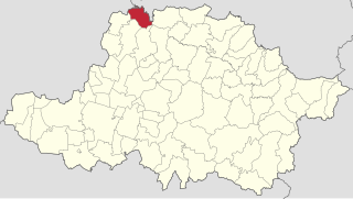
Târnova is a commune in Arad County, Romania, is situated in the contact zone of the Cigherului Hills and Zărandului Mountains, it occupies approximately 19,000 hectares. The commune is composed of six villages: Agrișu Mare (Almásegres), Arăneag (Székesaranyág), Chier (Kurtakér), Drauț (Doroszlófalva), Dud (Dúd) and Târnova.

Șiștarovăț is a commune in Arad County, Romania, is situated on the Lipova Hills and it occupies approximately 12,300 ha. It is composed of four villages: Cuveșdia (Temeskövesd), Labașinț (Lábas), Șiștarovăț and Varnița (Mészdorgos).

Șimand is a commune in Arad County, Romania. It is situated in the contact zone of the Arad and Criș Plateaus, on the Canalul Morilor and stretches over 10,028 ha. It is composed of a single village, Șimand, situated at 30 km (19 mi) from the county seat, Arad.