Șiria is a commune in Arad County, Romania. According to the 2002 census it had 8,140 inhabitants.
Bârsa is a commune in Arad County, Romania. The commune is situated in the Sebiș Basin, on the left part of the Mills Ditch and it has an administrative territory of 5174 ha. It is composed of four villages: Aldești (Áldófalva), Bârsa, Hodiș (Zarándhódos) and Voivodeni (Körösvajda).

Bocsig is a commune in Arad County, Romania. The commune is situated in the Ineu Basin, along the Crișul Alb River, and it stretches over 6,648 ha. It is composed of three villages: Bocsig, Mânerău (Monyoró) and Răpsig (Repszeg).

Brazii is a commune in Arad County, Romania. It is situated in the southern part of the Gurahonț Basin, at the western foot of Măgura Ciungani Mountains and at the northern foot of Husu Massif, in the hydrographical basin of the Sighișoara River. It is composed of five villages: Brazii, Buceava-Șoimuș (Solymosbucsa), Iacobini (Zöldes), Mădrigești (Madarsák) and Secaș (Alsószakács).

Buteni is a commune in Arad County, Romania. The river Crișul Alb flows nearby. Buteni commune lies in the Sebiș Basin at the foot of the Cuiedului Hills. It is composed of four villages: Berindia (Borosberend), Buteni, Cuied (Köved), and Păulian (Gósd).

Cărand is a commune in Arad County, Romania. Cărand commune is situated in the northern part of the Sebiș Basin, at the foot of Codru-Moma Mountains and its surface is 3813 ha. It is composed of two villages, Cărand and Seliștea (Bélmárkaszék).
Cermei is a commune in Arad County, Romania, situated in the Teuz Plateau, in the basin of the river Sartiș. It is composed of three villages: Avram Iancu (Püspökpuszta), Cermei and Șomoșcheș (Somoskeszi).
Susani may refer to several villages in Romania:

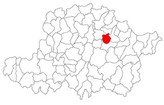
Dezna is a commune in Arad County, Romania. Located in the valley of the river Dezna about 7 km from Sebiș, it is composed of five villages: Buhani (Bajnokfalva), Dezna, Laz (Déznaláz), Neagra (Kisfeketefalu) and Slatina de Criș (Mikószlatina).

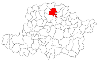
Dieci is a commune in Arad County, Romania. Dieci commune is situated in the Gurahonț Basin, on the right bank of the Crișul Alb River, and it stretches over 8469 hectares. It is composed of five villages: Cociuba (Köröskocsoba), Crocna (Koroknya), Dieci, Revetiș (Rékes) and Roșia (Borosrósa).
Dorobanți is a commune in Arad County, Romania. Dorobanți commune lies in the Arad Plateau and it stretches over 2780 hectare. It is composed of a single village, Dorobanți, split off from Curtici town in 2004. It is situated at 25 km from Arad.
Iratoșu is a commune in Arad County, Romania, on the Arad Plateau, at the western border of Romania. The commune stretches over 3,770 hectares and is composed of three villages: Iratoșu, Variașu Mare (Nagyvarjas), and Variașu Mic (Kisvarjaspuszta).

Livada is a commune in Arad County, Romania. Livada commune is situated on the Arad Plateau, northward from Arad. The commune stretches over 2013 hectares and is composed of two villages, Livada and Sânleani (Szentleányfalva).
Olari is a commune in Arad County, Romania, is situated on the Arad Plateau, on the Canalul Morilor, on the left bank of the river Crișul Alb. Its surface occupies 4767 ha. It is composed of two villages, Olari and Sintea Mică (Szineke).

Păuliș is a commune in Arad County, Romania, situated in the contact zone of the Mureș Couloir with the Arad Plateau and Zărand Mountains. The administrative territory of the commune is 12,806 hectares. The commune centre is situated at 25 km from Arad. It is composed of four villages: Barațca (Pálosbaracka), Cladova (Kalodva), Păuliș and Sâmbăteni (Szabadhely).

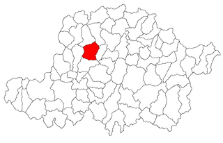
Pleșcuța, a commune in Arad County, Romania, is situated in the Hălmagiu Basin, at the foot of Codru-Moma Mountains and Metaliferi Mountains, along the upper course of the Crișul Alb River. It is connected with the Gurahonț Basin by the epigenetic defile of the Crișul Alb existing between Pleșcuța and Gurahonț. The commune stretches over 7000 hectares and is composed of seven villages: Aciuța (Acsuca), Budești (Bugyfalva), Dumbrava (Körösdombró), Gura Văii (Vojkaháza), Pleșcuța, Rostoci (Rosztócs) and Tălagiu (Talács).

Șagu is a commune in Arad County, Romania, is situated on the Vingăi Plateau and it stretches over 10266 hectares. It is composed of five villages: Cruceni, Firiteaz (Féregyház), Fiscut (Temesfűzkút), Hunedoara Timișană and Șagu.

Vărădia de Mureș is a commune in Arad County, Romania. It stretches over approximately 12600 hectares, situated in the contact zone of Metaliferi Mountains and Zărandului Mountains, respectively partially in the large valley of the Mureș River. It is composed of six villages: Baia (Kisbaja), Julița (Gyulatő), Lupești (Farkasháza), Nicolae Bălcescu (Alsóköves), Stejar (Szarvaság) and Vărădia de Mureș.

Șiștarovăț is a commune in Arad County, Romania, is situated on the Lipova Hills and it occupies approximately 12,300 ha. It is composed of four villages: Cuveșdia (Temeskövesd), Labașinț (Lábas), Șiștarovăț and Varnița (Mészdorgos).

Șimand is a commune in Arad County, Romania. It is situated in the contact zone of the Arad and Criș Plateaus, on the Canalul Morilor and stretches over 10,028 ha. It is composed of a single village, Șimand, situated at 30 km (19 mi) from the county seat, Arad.