The International Polar Years (IPY) are collaborative, international efforts with intensive research foci on the polar regions. Karl Weyprecht, an Austro-Hungarian naval officer, motivated the endeavor in 1875, but died before it first occurred in 1882–1883. Fifty years later (1932–1933) a second IPY took place. The International Geophysical Year was inspired by the IPY and was organized 75 years after the first IPY (1957–58). The fourth, and most recent, IPY covered two full annual cycles from March 2007 to March 2009.

The climate of Antarctica is the coldest on Earth. The continent is also extremely dry, averaging 166 mm (6.5 in) of precipitation per year. Snow rarely melts on most parts of the continent, and, after being compressed, becomes the glacier ice that makes up the ice sheet. Weather fronts rarely penetrate far into the continent, because of the katabatic winds. Most of Antarctica has an ice-cap climate with very cold, generally extremely dry weather.

The weather satellite is a type of satellite that is primarily used to monitor the weather and climate of the Earth. Satellites can be polar orbiting, covering the entire Earth asynchronously, or geostationary, hovering over the same spot on the equator.

Polar mesospheric clouds (PMCs) are a diffuse scattering layer of water ice crystals near the summer polar mesopause.

Atmospheric physics is the application of physics to the study of the atmosphere. Atmospheric physicists attempt to model Earth's atmosphere and the atmospheres of the other planets using fluid flow equations, chemical models, radiation budget, and energy transfer processes in the atmosphere. In order to model weather systems, atmospheric physicists employ elements of scattering theory, wave propagation models, cloud physics, statistical mechanics and spatial statistics which are highly mathematical and related to physics. It has close links to meteorology and climatology and also covers the design and construction of instruments for studying the atmosphere and the interpretation of the data they provide, including remote sensing instruments. At the dawn of the space age and the introduction of sounding rockets, aeronomy became a subdiscipline concerning the upper layers of the atmosphere, where dissociation and ionization are important.

The Byrd Polar and Climate Research Center (BPCRC) is a polar, alpine, and climate research center at The Ohio State University founded in 1960.

Bennett Island is the largest of the islands of the De Long Islands in the northern part of the East Siberian Sea. The area of this island is approximately 150 square kilometres and it has a tombolo at its eastern end. The highest point of the island is 426 metres high Mount De Long, the highest point of the archipelago. Bennett Island is part of the Yakutia administrative division of Russia.

Verner Edward "Vern" Suomi was a Finnish-American educator, inventor, and scientist. He is considered the father of satellite meteorology. He invented the Spin Scan Radiometer, which for many years was the instrument on the GOES weather satellites that generated the time sequences of cloud images seen on television weather shows. The Suomi NPP polar orbiting satellite, launched in 2011, was named in his honor.

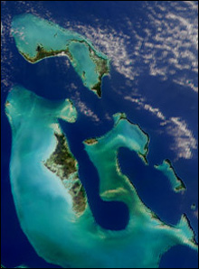
The "color" of the ocean is determined by the interactions of incident light with substances or particles present in the water. White light from the sun is made up of a combination of colors that are broken apart by water droplets in a "rainbow" spectrum. Large quantities of water, even in a swimming pool, would appear blue as well. When light hits the water surface, the different colors are absorbed, transmitted, scattered, or reflected in differing intensities by water molecules and other so-called optically-active constituents in suspension in the upper layer of the ocean. The reason that open ocean waters often appear blue is due to the absorption and scattering of light. The blue wavelengths of light are scattered, similar to the scattering of blue light in the sky but absorption is a much larger factor than scattering for the clear ocean water. In water, absorption is strong in the red and weak in the blue and so red light is absorbed quickly in the ocean leaving blue. Almost all sunlight that enters the ocean is absorbed, except very close to the coast. The red, yellow, and green wavelengths of sunlight are absorbed by water molecules in the ocean. When sunlight hits the ocean, some of the light is reflected back directly, but most of it penetrates the ocean surface and interacts with the water molecules that it encounters. The red, orange, yellow, and green wavelengths of light are absorbed and so the remaining light we see is composed of the shorter wavelength blues and violets.
The Cooperative Institute for Meteorological Satellite Studies (CIMSS) is a research institute where scientists study the use of data from geostationary and polar orbit weather satellites to improve forecasts of weather (including tropical cyclones and severe storms. CIMSS was formed through a Memorandum of Understanding between the University of Wisconsin–Madison, the National Oceanic and Atmospheric Administration and the National Aeronautics and Space Administration. CIMSS parent organization, the Space Science and Engineering Center is a primary developer and operator of environmental satellite technologies.

The Antarctica cooling controversy was the result of an apparent contradiction in the observed cooling behavior of Antarctica between 1966 and 2000 became part of the public debate in the global warming controversy, particularly between advocacy groups of both sides in the public arena including politicians, as well as the popular media. In his novel State of Fear, Michael Crichton asserted that the Antarctic data contradict global warming. The few scientists who have commented on the supposed controversy state that there is no contradiction, while the author of the paper whose work inspired Crichton's remarks has said that Crichton misused his results. There is no similar controversy within the scientific community, as the small observed changes in Antarctica are consistent with the small changes predicted by climate models, and because the overall trend since comprehensive observations began is now known to be one of warming.
McIDAS, the "Man computer Interactive Data Access System", is a weather forecasting tool developed at the University of Wisconsin–Madison in the 1970s and used continually to this day. In its early incarnations, it was widely used to generate graphics for television stations, but today is used primarily by the NOAA and related agencies. Users of the McIDAS system developed a similar version for microcomputers and sold by ColorGraphics Weather Systems that generated much of the computerized weather imagery seen on television in the US in the 1980s.
The Space Science and Engineering Center (SSEC) is a research and development center with primary focus on Earth science research and technology to enhance understanding of the atmosphere of Earth, the other planets in the Solar System, and the cosmos. SSEC is part of the University of Wisconsin–Madison's Graduate School.

Prem Chand Pandey is an Indian scientist and academic in the fields of Satellite Oceanography, Remote Sensing, Atmospheric Science, Antarctic and Climate Change

Measurement of sea ice is important for safety of navigation and for monitoring the environment, particularly the climate. Sea ice extent interacts with large climate patterns such as the North Atlantic oscillation and Atlantic Multidecadal Oscillation, to name just two, and influences climate in the rest of the globe.

Mario Giovinetto is an Argentine glaciologist, climatologist, and geographer. He is a Canadian citizen with permanent resident status in the US.

The Antarctic Meteorological Research Center (AMRC) is an Antarctic research program funded by the National Science Foundation (NSF) that is based out of the Space Science and Engineering Center (SSEC) at the University of Wisconsin. The AMRC was founded as a link between the UW-Madison automatic weather station (AWS) project and the Man computer Interactive Data Access System (McIDAS) project, also at UW-Madison.
The Antarctic Automatic Weather Station (AWS) Project is an Antarctic research program at the Space Science and Engineering Center at the University of Wisconsin–Madison that is funded by the Office of Polar Programs at the National Science Foundation (NSF). The AWS project was started in 1980 by UW-Madison atmospheric sciences Professor Charles R. Stearns.

The Suomi National Polar-orbiting Partnership or Suomi NPP, previously known as the National Polar-orbiting Operational Environmental Satellite System Preparatory Project (NPP) and NPP-Bridge, is a weather satellite operated by the United States National Oceanic and Atmospheric Administration. It was launched in 2011 and continues to operate.

Claire L. Parkinson is an American Earth scientist and climatologist at NASA's Goddard Space Flight Center.


