Lake Mendota is a freshwatereutrophic lake that is the northernmost and largest of the four lakes in Madison, Wisconsin.[2] The lake borders Madison on the north, east, and south, Middleton on the west, Shorewood Hills on the southwest, Maple Bluff on the northeast, and Westport on the northwest.[3] The lake was historically known as Wąąkšikhomįkra (Where the Person Rests) by the Ho-Chunk people.[4] Lake Mendota acquired its present name in 1849 following a proposal by a surveyor named Frank Hudson, who claimed to be familiar with local Native American languages; Lyman C. Draper, the first corresponding secretary of the Wisconsin Historical Society, proposed that 'Mendota' could have been a Chippewa word meaning 'large' or 'great.'[5]
Lake Mendota originated after the Wisconsin glaciation, which occurred approximately 15,000 years ago. Glacial ice, which had covered the Madison lakes (Lakes Mendota, Monona, Kegonsa, and Waubesa)[6] at a thickness of over 300 meters, began to retreat northwest about 14,000 years ago, damming a glacial lake near the City of Middleton that now serves as the source of water for Pheasant Branch, a creek that drains from the east into Lake Mendota. Water left behind by the retreating glaciers eventually filled the current lake bed of Lake Mendota. Although a large lake that stretched from the northern part of Lake Mendota down to Stoughton did exist for about 1,000 years, falling water levels caused this large lake to separate into the four current Madison lakes about 10,000 years ago, leaving numerous shallow-water marshes between those lakes.[7]
According to reports from European settlers in the early nineteenth century, Lake Mendota once had white sand beaches and clear water, with the sand being calcium carbonate, which continually entered the lake from its gypsum-richwatershed. However, after American settlers began to populate Madison, the physical characteristics of the once-mesotrophic lake[2] began to rapidly change. This was largely due to the Tenney Locks, which were constructed in 1849 to regulate shipping through the Madison Isthmus and led to a four-foot increase in the water level in Lake Mendota, submerging the beaches. Additionally, due to the growth of the Wisconsin dairy industry in the late nineteenth century, Lake Mendota was repeatedly inundated with runoff from nearby farms that caused the lake bed to become dark black, the color of prairie soil. The resulting spikes in the concentrations of nitrogen and phosphorus turned Lake Mendota into a eutrophic lake. The degree of eutrophication was so high that in 1882, Edward Asahel Birge, a young zoologist and future president of the University of Wisconsin-Madison, documented Lake Mendota's first known toxic cyanobacterial blooms in conjunction with his collaborator Chancey Juday, marking the first step toward long-term studies of Lake Mendota.[8]
Geography
Lake Mendota and Lake Monona are separated by an isthmus known as the Madison Isthmus, on which the majority of Madison, WI, is located.[9] While the lakes are separated by dry ground, they are connected by the Yahara River. Navigation along this portion of the Yahara River is controlled by the Tenney Park Lock and Dam, which was constructed to allow shallow drafting boats to cross this dredged section of river through what was once wetlands. Today, the Tenney Park Locks also help to maintain water levels in the Madison lakes, as under normal conditions, the water level in Lake Mendota is kept five feet above that in Lake Monona. By contrast, when water levels are too high, the Tenney Park Dam is closed to minimize flow from Lake Mendota into Lake Monona and Lake Waubesa, while when water levels are too low, all the dams along the Yahara River are opened to maximize water flow.[10][11] In early 2021, Dane County obtained an Ellicott 'Dragon Dredge' as a means of reducing the consequences of flooding from the Yahara River and the Madison lakes by removing silt and muck deposits that have accumulated for decades at choke points between the lakes. This acquisition was part of a multi-million dollar flood mitigation effort led by Dane County Executive Joe Parisi dating back to 2019, when historic rains inundated creeks and caused the waters of Lake Monona to rise to their highest levels in over a century, that would allow Dane County to more efficiently move large volumes of water between the Madison lakes to avoid similar catastrophic impacts from flooding.[12]
Lake Mendota has been called "the most studied lake in the world," with the UW–Madison Center for Limnology resting on its southern bank.[23] The lake has a remote sensor buoy, affectionately known as 'David Buoy,' that is part of the Global Lake Ecological Observatory Network. The buoy was first anchored in Lake Mendota in 2008 and has collected data in each subsequent year from early spring until late fall, when it is removed before the lake freezes in the winter. Several of the lake and atmospheric data collected by the buoy include wind direction, wind speed, air temperature, dissolved oxygen, and chlorophyll.[24] In March 2021, researchers from the Center for Limnology concluded that climate change and the associated lengthening of summer weather have driven the annual formation of dead zones in Lake Mendota, which are oxygen-deficient layers deep in the water column. These dead zones have been shown to remain in the lake for up to two months in the summer and have the potential to devastate the habitats of benthic fish. The increasing eutrophication of Lake Mendota has led to an increased frequency of harmful algal blooms, which sink to the bottom of the lake when they die. Once at the bottom, they are broken down by decomposers via a process that requires oxygen, thus depleting the benthic supply of oxygen and forming dead zones. In the absence of programs designed to mitigate climate change locally, the researchers indicated that the only way to reduce the frequency and severity of the dead zones is to limit the amount of fertilizer and nutrients that flow into Lake Mendota.[25][26]
On September 11, 2009, the invasive spiny water flea was discovered by the limnology class at the University of Wisconsin–Madison, making it the third known inland lake to harbor this species in Wisconsin.[27] Scientists from the Long Term Ecological Research Network had initially believed that Lake Mendota was an unsuitable habitat for the spiny water flea, which prefers cold lakes, as limnologists from the North Temperate Lakes site of the LTER had conducted over three decades of sampling trips into the lake and had never found a single spiny water flea. However, after extracting sediment cores from Lake Mendota and analyzing them at the UW–Madison Zoological Museum, researchers found evidence that spiny water fleas had been present in low concentrations in the lake for at least a decade before their sudden population increase in 2009. This conforms with recent research proposing that invasive species can spend years or decades as "sleeper populations," remaining at low population densities until environmental conditions become favorable for explosive population growth, at which point they are detected by researchers.[28][29] In 2015, a reproducing population of invasive zebra mussels was found in Lake Mendota, which generated concern among ecologists because the mussels have been linked to increases in the frequency of cyanobacteria blooms and beach closures.[30]
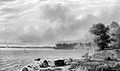
Lake Mendota as seen from the University Bay landing in the fall of 2008
Artifacts
On November 2, 2021, a team from the Wisconsin Historical Society raised a dugout canoe to the surface of Lake Mendota. It was discovered by marine archeologist Tamara Thomsen and SCUBA assistant Mallory Dragt while joyriding on their scooters in June 2021. At 1200 years old, it was the oldest known sunken boat/shipwreck in Wisconsin at that time.[39]
On September 22, 2022, a team from the Wisconsin Historical Society raised a dugout canoe to the surface of Lake Mendota. At 3,000 years old, it is now the oldest known sunken boat/shipwreck in Wisconsin.[40]
Gallery
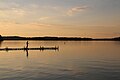
Lake Mendota viewed from the steps of the Memorial Union
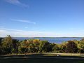
Lake Mendota viewed from the top of Observatory Drive
↑Eyck, Masarah Van (August 29, 2016). "Lake Mendota: a scientific biography". University of Wisconsin–Madison College of Letters and Science. Retrieved April 9, 2021.
This page is based on this Wikipedia article Text is available under the CC BY-SA 4.0 license; additional terms may apply. Images, videos and audio are available under their respective licenses.