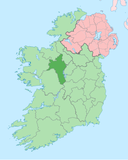
County Roscommon is a county in Ireland. In the western region, it is part of the province of Connacht. It is the 11th largest Irish county by area and 27th most populous. Its county town and largest town is Roscommon. Roscommon County Council is the local authority for the county. The population of the county was 64,544 as of the 2016 census.

Ballyveelick is a townland in the civil parish of Castletownroche, County Cork, Ireland. It is 0.7 square kilometres (0.3 sq mi) in area, and had a population of 5 people as of the 2011 census.

Ardcarn or Ardcarne, is a civil parish in County Roscommon, Ireland.
Brickeens is a very small townland in County Longford, Ireland. It is about five kilometres north of Keenagh and eight kilometres south of Longford town. Brickeens townland has an area of approximately 146 acres (0.2 sq mi), and had a population of 21 people as of the 2011 census. Evidence of ancient settlement in the townland include two ringforts.
Rathard is a ringfort (rath) and National Monument located in County Limerick, Ireland.
Larkfield fort is a ringfort (rath) and National Monument located in County Longford, Ireland. On the Record of Monuments and Places it bears the code LF006-021----.
Rathanadav, also called Carron Henge, Rathnadob, Rathnadov or Fort Aengus, is a ringfort (rath) and henge, and a National Monument located in County Tipperary, Ireland.
Tornant Moat is an Irish National Monument composed of a ringfort and nearby barrows.
Castle Naghten is a motte and National Monument located in County Roscommon, Ireland.
Carnagh West Ringfort is a ringfort and National Monument located in County Roscommon, Ireland.
Lismacrory Mounds are a group of prehistoric mounds forming a National Monument in County Tipperary, Ireland. They are 2.2 km (1.4 mi) north of Ballingarry, North Tipperary, 10 km (6.3 mi) southeast of Lough Derg.
Cahervagliar is a ringfort (rath) and National Monument (#233) located in County Cork, Ireland.
The Cush Earthworks are a series of earthworks, and a National Monument, located in County Limerick, Ireland.
Kilmihill Ringfort is a ringfort (rath) and National Monument located in County Limerick, Ireland. On the Record of Monuments and Places its code is LI037-042.
Cloghanecarhan is a ringfort and ogham stone forming a National Monument located in County Kerry, Ireland.

Loher Cashel is a stone ringfort (cashel) and National Monument located on the Iveragh Peninsula, Ireland.

Annagh Church is a medieval church and National Monument in County Kerry, Ireland.
Leacanabuaile is a stone ringfort (cashel) and National Monument in County Kerry, Ireland. Leacanabuaile is immediately northwest of Cahergal, 3 km (1.9 mi) northwest of Cahirciveen.
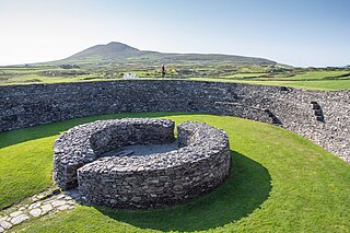
Cahergall is a stone ringfort (cashel) and National Monument located in County Kerry, Ireland.
Callanafersy is a stone ringfort (cashel) and National Monument located in County Kerry, Ireland.
