Manali is a resort town nestled in the mountains of the Indian state of Himachal Pradesh near the northern end of the Kullu Valley in the Beas River Valley. It is located in the Kullu district, about 270 km (168 mi) north of the state capital, Shimla, 309 km north east of Chandigarh and 544 km northeast of Delhi, the federal capital. The small town, with a population of 8,096, is the beginning of an ancient trade route to Ladakh and from there over the Karakoram Pass on to Yarkand and Khotan in the Tarim Basin. It is a popular tourist destination and serves as the gateway to Lahaul and Spiti district as well as Leh.

The Rashtrapati Niwas, also known as Viceregal Lodge, is located on the Observatory Hills of Shimla, Himachal Pradesh, India. It was formerly the residence of the British Viceroy of India. It houses some of the most ancient articles and photographs going back to the times of the British rule in India.

Barog is a hill station in Solan district in the Indian state of Himachal Pradesh. The station lies on UNESCO World Heritage Site Kalka–Shimla Railway. Set in the mountains Barog is just 60 km from Chandigarh on the Kalka-Shimla highway.

Jubbal is a town and a nagar panchayat in Shimla district in the Indian state of Himachal Pradesh. Website[www.Himstates.com]
Kotkhai is a town and a nagar panchayat in Shimla district in the Indian state of Himachal Pradesh. It is a tehsil with around 40 villages in it. The whole tehsil is known for apple production. The Baghi village situated in Kotkhai has the largest production of apples in Himachal which includes 22lakhs of apple boxes being produced every year including Ratnari, Kalbog and Kyarvi panchyat (villages).

Theog is a town and a municipal committee as well as a tehsil in Shimla district in the Indian state of Himachal Pradesh. First settlements were in 1902.
Mashobra is a town in Shimla district of Himachal Pradesh. It is connected to the state capital Shimla through the historic Hindustan–Tibet Road built in 1850 by Lord Dalhousie.
Rampur Bushahr is a town and a municipal council in Shimla district in the Indian state of Himachal Pradesh. It is 130 km from Shimla and is well connected with National Highway 5 which passes through Narkanda.
Shillai is a small town in Northern India, Himachal Pradesh (state). It comes under Sirmaur district. Shillai is located on a south east-facing hill at an elevation of 1,900 metres. The hill is called dhar shillai, and is 2,100 meters high. A degree college was established in 2006.
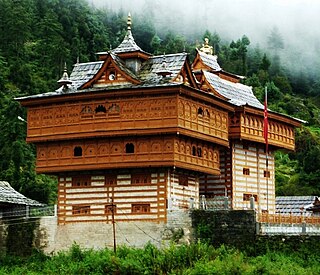
Sarahan is a small village in Himachal Pradesh of India. It is the site of the Bhimakali Temple, originally known as Bhimadevi Temple, dedicated to the mother goddess Bhimakali, presiding deity of the rulers of the former Bushahr State. The temple is situated about 170 kilometres from Shimla and is one of 51 Shakti Peethas. The village is known as the "gateway of Kinnaur" it being near the old Indo-Tibetan Road. Seven kilometers below Sarahan is the river Satluj. Sarahan is identified with the Shonitpur mentioned in Puranas. Sarahan Bushahr has been the summer capital of Bushahr kingdom, with Rampur Bushahr considered the winter capital. The former Chief Minister of Himachal Pradesh Shree Virbhadra Singh is a member of royal family and is popularly known as "Raja Sahab" at Sarahan. He has been member of the Assembly/Parliament since 1962 and has held the post of Chief Minister six times. His wife Rani Pratibha Devi is also a member of Assembly.

Tara Hall is an English-medium high school located in Shimla, Himachal Pradesh, India. The school is run by the Loreto Education Society. It is one of the best schools for girls in Shimla.
Sungri is a hill station in Himachal Pradesh, India. It is located in the Rohru block, and comes under the administration of Bhaloon panchayat. As a hill station, it is a popular travel destination popular among domestic tourists.

Hatkoti is a town in Shimla district in the Indian state of Himachal Pradesh. It is a town located at the banks of Pabbar River and it is about 102 kilometres away from Shimla city. Hatkoti is also famous for Hateshwari temple and Sawra Kuddu Hydro Electric Project.
Sawra is a town in Shimla district in the Indian state of Himachal Pradesh. Sawra is also known as Saraswati Nagar. It is a town located at the banks of Pabbar River and it is about 103 kilometres away from Shimla and 12 kilometres away from Rohru. Sawra is also famous for Sawra Kuddu Hydro Electric Project.

Bhalara is a village in Himachal Pradesh, India. It is located in the Rohru block of the Shimla district, and is situated 15 km from the Rohru town. It
Sharog is a village in Shimla district in the Indian state of Himachal Pradesh. It is a located near the town of Rohru and is about 125 kilometres (78 mi) away from Shimla and 8 km from Rohru. There is a temple of Devi Jaga Mata and the people of this village worship Dhonlu Devta, Shalonu Devta and Mahasu Maharaj. There is a temple of Dhonlu Devta.
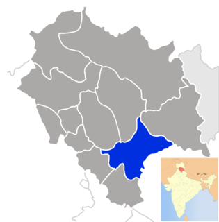
Rohru is one of the 68 constituencies in the Himachal Pradesh Legislative Assembly of Himachal Pradesh a northern state of India. Rohru is also part of Shimla Lok Sabha constituency.

Bari is a village in Rohru sub-district in Shimla district of Himachal Pradesh state, India.