Aribinda Airport

Last updated
Aribinda Airport
Summary
Serves Aribinda, Soum Province, Sahel Region, Burkina Faso
LocationFlag of Burkina Faso.svg  Burkina Faso
Coordinates 14°13′00″N00°53′00″W / 14.21667°N 0.88333°W / 14.21667; -0.88333
Maps
BF-12 Sahel.svg
Sahel Region in Burkina Faso
Burkina Faso location map.svg
Airplane silhouette.svg
XAR
Location of the airport in Burkina Faso

Aribinda Airport ( IATA : XAR, ICAO : DFOY) is an airport serving the village of Aribinda in the Soum Province, part of the Sahel Region of Burkina Faso.

The airport is likely long abandoned. There is currently no paved or marked runway near any of six different coordinate pairs for Aribinda available on the internet. Neither is any historical or runway information posted at any web site with a page for Aribinda. [1] [2] [3] [4] [5] [6] However, a listing for the airfield still appears in the official ASECNA Aeronautical Information Publication for Burkina Faso, quoting coordinates N14 13.0 W000 53.0. [7] Furthermore, the airport still has a valid 3-letter code allocated by IATA, [8] though a search of the ICAO database reveals no 4-letter ICAO location indicator code. [9]

Related Research Articles

<span class="mw-page-title-main">ICAO airport code</span> Four-letter code designation for aviation facilities around the world

The ICAOairport code or location indicator is a four-letter code designating aerodromes around the world. These codes, as defined by the International Civil Aviation Organization and published in ICAO Document 7910: Location Indicators, are used by air traffic control and airline operations such as flight planning. ICAO codes are also used to identify other aviation facilities such as weather stations, international flight service stations or area control centers, whether or not they are located at airports. Flight information regions are also identified by a unique ICAO-code.

<span class="mw-page-title-main">Bobo Dioulasso Airport</span> Airport

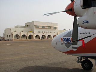
Bobo Dioulasso Airport is an international airport in Bobo Dioulasso, Burkina Faso.

Bogandé Airport is a public use airport located near Bogandé, Gnagna, Burkina Faso.

<span class="mw-page-title-main">Djibo Airport</span> Airport in Burkina Faso

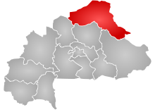
Djibo Airport is an airport serving the village of Djibo in the Soum Province, part of the Sahel Region of Burkina Faso.

Gorom Gorom Airport is a public-use airport located two kilometres east-northeast of Gorom Gorom, Oudalan, Burkina Faso.

Leo Airport is a public use airport located near Leo, Sissili, Burkina Faso.

<span class="mw-page-title-main">Sebba Airport</span> Airport in Burkina Faso

Sebba Airport is an airport serving the village of Sebba in the Yagha Province, part of the Sahel Region of Burkina Faso.

<span class="mw-page-title-main">Tambao Airport</span> Airport in Burkina Faso

Tambao Airport is an airstrip serving the manganese mining site of Tambao in the Oudalan Province, part of the Sahel Region of Burkina Faso.

Tenkodogo Airport is a public use airport located near Tenkodogo, Boulgou, Burkina Faso.

Gaoua Airport is a public use airport located near Gaoua, Poni, Burkina Faso.

Barsalogho Airport is a public use airport located near Barsalogho, Sanmatenga, Burkina Faso. The single runway is unmarked except for the remains of the end marker at the north end and may be unusable.

Arly Airport is a public use airport located near Arli National Park or Arly, Tapoa Province, Burkina Faso. While the runway outline is clearly visible, it appears overgrown with vegetation and may be unusable. However, the airfield is still listed in the official ASECNA Aeronautical Information Publication for Burkina Faso and has an official IATA 3-letter code, though its 4-letter code does not appear to be recognised by ICAO.

Dédougou Airport is a public use airport located near Dédougou, Mouhoun, Burkina Faso.

References

  1. "Google Maps". Google Maps. Retrieved 2018-08-20.
  2. "Google Maps". Google Maps. Retrieved 2018-08-20.
  3. "Google Maps". Google Maps. Retrieved 2018-08-20.
  4. "Google Maps". Google Maps. Retrieved 2018-08-20.
  5. "Google Maps". Google Maps. Retrieved 2018-08-20.
  6. "Google Maps". Google Maps. Retrieved 2018-08-20.
  7. "AIS ASECNA - Ad.2 : Aérodromes". www.ais-asecna.org. Archived from the original on 2018-08-20. Retrieved 2018-08-20.
  8. IATA. "IATA - Codes - Airline and Airport Codes Search". www.iata.org. Retrieved 2018-08-20.
  9. "API Data Service". www.icao.int. Retrieved 2018-08-20.