Tambao Airport

Last updated
Tambao Airport
Summary
Serves Tambao, Oudalan Province, Sahel Region, Burkina Faso
LocationFlag of Burkina Faso.svg  Burkina Faso
Elevation  AMSL 250 m / 820 ft
Coordinates 14°47′25″N0°02′20″E / 14.79028°N 0.03889°E / 14.79028; 0.03889 Coordinates: 14°47′25″N0°02′20″E / 14.79028°N 0.03889°E / 14.79028; 0.03889
Maps
BF-12 Sahel.svg
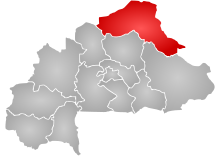
Sahel Region in Burkina Faso
Burkina Faso location map.svg
Airplane silhouette.svg
TMQ
Location of the airport in Burkina Faso
Runways
Direction Length Surface
ft m
07/25 3,610 1,100 Sand
Source: Bing Maps [1] Landings.com, [2] Google, [3] STV [4]

Tambao Airport( IATA : TMQ, ICAO : DFEM) is an airstrip serving the manganese mining site of Tambao in the Oudalan Province, part of the Sahel Region of Burkina Faso.

An IATA airport code, also known as an IATA location identifier, IATA station code or simply a location identifier, is a three-letter code designating many airports around the world, defined by the International Air Transport Association (IATA). The characters prominently displayed on baggage tags attached at airport check-in desks are an example of a way these codes are used.

ICAO airport code four-letter code designating many airports around the world

The ICAOairport code or location indicator is a four-letter code designating aerodromes around the world. These codes, as defined by the International Civil Aviation Organization and published in ICAO Document 7910: Location Indicators, are used by air traffic control and airline operations such as flight planning.

Tambao village in Burkina Faso

Tambao is a Manganese deposit and potential mine site in the Oudalan Province, located in the Sahel Region, which the far northeastern part of Burkina Faso. Tambao has been estimated, when exploited, to be one of the largest deposits in the region. Its development, a major priority of the Burkinabe state, has been an on and off project since the 1990s. Barely served by roads or other infrastructure, the Tambao reserves are some 210 kilometres (130 mi) north of Kaya and 350 kilometres (220 mi) northeast of the capital, namely Ouagadougou. The Tambao Airport has been recently built to serve the deposit and the corresponding villages.

Contents

See also

Related Research Articles

Boulsa Airport

Boulsa Airport is a public use airport located near Boulsa, Namentenga, Burkina Faso.

Diapaga Airport

Diapaga Airport is a public use airport located near Diapaga, Tapoa, Burkina Faso.

Djibo Airport

Djibo Airport is an airport serving the village of Djibo in the Soum Province, part of the Sahel Region of Burkina Faso.

Dori Airport

Dori Airport is a public use airport located 2 nm west of Dori, Séno, Burkina Faso.

Fada Ngourma Airport

Fada N'Gourma Airport is a public use airport located 1 nm south-southeast of Fada N'Gourma, Gourma, Burkina Faso.

Gorom Gorom Airport

Gorom Gorom Airport is a public use airport located 1 nautical mile east-northeast of Gorom Gorom, Oudalan, Burkina Faso.

Kantchari Airport

Kantchari Airport is a public use airport located near Kantchari, Tapoa, Burkina Faso.

Kaya Airport

Kaya Airport is a public use airport located near Kaya, Sanmatenga, Burkina Faso.

Leo Airport

Leo Airport is a public use airport located near Leo, Sissili, Burkina Faso.

Nouna Airport

Nouna Airport is a public use airport located near Nouna, Kossi, Burkina Faso.

Ouahigouya Airport

Ouahigouya Airport is a former public use airport located near Ouahigouya, Yatenga, Burkina Faso.

Pama Airport

Pama Airport is a public use airport located near Pama, Kompienga Province, Burkina Faso.

Sebba Airport

Sebba Airport is an airport serving the village of Sebba in the Yagha Province, part of the Sahel Region of Burkina Faso.

Tenkodogo Airport

Tenkodogo Airport is a public use airport located near Tenkodogo, Boulgou, Burkina Faso.

Tougan Airport

Tougan Airport is a public use airport located near Tougan, Sourou, Burkina Faso.

Pô Airport

Pô Airport is a public use airport located near Pô, Nahouri, Burkina Faso.

Gaoua Airport

Gaoua Airport is a public use airport located near Gaoua, Poni, Burkina Faso.

Houndé Airport

Houndé Airport is a public use airport located near Houndé, Tuy, Burkina Faso.

Dédougou Airport

Dédougou Airport is a public use airport located near Dédougou, Mouhoun, Burkina Faso.

Diébougou Airport

Diébougou Airport is a public use airport located near Diébougou, Bougouriba, Burkina Faso.

References

  1. Bing Maps - Tambao runway
  2. Airport record for Tambao Airport at Landings.com. Retrieved 2013-08-22
  3. Google (2013-08-22). "location of Tambao Airport" (Map). Google Maps . Google. Retrieved 2013-08-22.
  4. Airport information for Tambao Airport at Search (for) Travel website.