Banswara is a town in the Banswara district in southern Rajasthan, India. The name, Banswara, came from king ‘Bansiya Bhil’
Govardhan also called Giriraj, is a key pilgrimage centre in India and a municipal town; a nagar panchayat; seat of a MLA Member of Legislative Assembly of Uttar Pradesh; a Tehsil, in Mathura district in the India in state of Uttar Pradesh. About 23 kilometres from Mathura, the town is on the road link between Mathura and Deeg.

Rajgarh district is a district of Madhya Pradesh in central India. The city of Rajgarh is the administrative headquarters of the district. The old name of Rajgarh was Jhanjhanipur. Rajgarh in Madhya Pradesh is one of the aspirational districts selected by Government of India. The district has an area of 6,154 km² and the population is 1,545,814. The district lies on the northern edge of the Malwa plateau, and the Parbati River forms the eastern boundary of the district, while the Kali Sindh River forms the western boundary. The district has seven tehsils, Rajgarh, Khilchipur, Jirapur, Biaora, Narsinghgarh, Sarangpur and Pachore. The district is bounded by Rajasthan state to the north, and by the districts of Guna to the northeast, Bhopal to the east, Sehore to the southeast, and Shajapur to the south and west. It is part of Bhopal Division. There are 1728 villages in Rajgarh.

Alwar is a district in the state of Rajasthan in northern India, whose district headquarters is Alwar city. The district covers 8,380 km2. It is bound on the north by Rewari district of Haryana, on the east by Bharatpur district of Rajasthan and Nuh district of Haryana, on the south by Dausa district, and on the west by Jaipur district.
Gogunda is a town and tehsil headquarters of Gogunda Tehsil in Udaipur district, located about 35 km (22 mi) in north-west from Udaipur city in the Indian state of Rajasthan. It is situated on a high mountain in Aravalli hills and is reached by crossing a difficult mountain pass.

Jodhpur District is a district in the State of Rajasthan in western India. The city of Jodhpur is the administrative headquarters of the district.
Asind is a city and a municipality in Bhilwara district, Rajasthan, India. It is a Tehsil (sub-division) for many villages The city have a magistrate office, lower justice court and many administrative hub for many major villages.
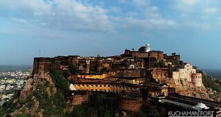
Kuchaman is a Municipal council and District headquarters of Kuchaman District located in Urban Area of central-west Rajasthan, India. It is the largest city of newly Kuchaman district in the Indian state of Rajasthan. The city includes a lots of Havelis in the Shekhawati and Marwari style and a fort overlooking the city. Fresco paintings there depict flowers, motifs, and Hindu mythology.The Kuchaman city lies about midway between Jodhpur, Jaipur, Ajmer and Sikar.

Sardarshahar is a city located in the Churu district of Rajasthan, India. It is also the seat of the Rajasthan legislative assembly Sardarshahar Assembly constituency. Sardarshahar is the tehsil headquarter. and part of the Churu Lok Sabha constituency. Sardarshahar was established in 1838 at the place of "Alwana" village in Bikaner state. The city is named after Sardar Singh, The son of Bikaner Maharaja(Raja Ratan Singh). It is known for its grand Havelis (mansions) with frescoes, The only Clock Tower (GhantaGhar) in Asia which streets running under it in all four directions, Shri Ichha Puran Balaji Mandir, Acharya Shri Mahapragya Samadhi Sthal(ShantiPeeth), Gandhi Vidya Mandir and many more. It is famous for its Food, handicraft work, silver work, and woodwork. It is the birthplace of the Eleventh Acharya -Acharyashri Mahashramanji of the Shri Jain Terapanthi Sect.
Jhajhar is a village, situated in the erstwhile province of Shekhawati of Rajasthan, India. It is located in the Jhunjhunu District, approximately 7 km from Nawalgarh. Formally it was the part of Pentalisa of Bhojyana.

Pratapgarh district is the 33rd district of Rajasthan, created on 26 January 2008. It is a part of Udaipur Division and has been carved out from the erstwhile tehsils of Chittorgarh, Udaipur and Banswara districts. Pratapgarh town is the administrative headquarters of the district.
Gudamalani is a town and Tehsil within the Barmer district of Rajasthan state of India. The village is located in the Thar Desert. Gudamalani is situated on the highway connecting Jodhpur to Ahmedabad. This area, unlike the Thar Desert area, is somewhat green and the land is fertile. The Luni River of Rajasthan flows through Gudamalani. This town in near several historical temples, such as Aalam Ji's Temple, Bhuteswar Temple, Guru Jambheswer Bhagwan Temple with Darmshala, and Bholaghar Ji Temple.
Ghanerao is a village in Desuri tehsil of Pali district of Rajasthan.
Jakham Dam is a dam located in Pratapgarh District in Rajasthan in India. It is located in Anooppura village of Pratapgarh Tehsil, 32 km from Dhariawad and 35 km from Pratapgarh town. The dam is a main irrigation project of the area.
Peepal Khoont mainly known as Pipalkhunt is a village, Tehsil headquarter and Panchayat Samiti of the Pratapgarh district of Rajasthan state. It is a sub-division among the 5 sub-divisions of the Pratapgarh district. The main market is called Sadar Bajar. It is situated on National Highway 113. Pipalkhunt is a town located on the Banswara - Jaipur Expressway surrounded by the hills, plants and trees. The town is situated on the bank of the Mahi River.
Abhaypura is a village in Nawa tehsil of Didwana Kuchaman District of Rajasthan state in India, named after Maharaja Abhay Singh of Marwar. It was one of the 40 villages in the Princely State Abhaypura which was half of Maroth state and was founded around 1683 AD by Maharaja Bijay Singh, third son of Maharaja Raghunath Singh Mertia of Panch Mahal Maroth. Later, after a treaty in 1820 AD it became a Thikana of Marwar and is now called as Thikana Jiliya and has 14 villages, as the rest of the villages were given as appanages or jagirs to younger brothers.
Maroth is a village located in Nawa, Nagaur district, in the state of Rajasthan, India. The area surrounding the village is named Gaurati, which means "The Land of Gaurs". This area was a principality granted by Maharaja Vigharaj Chauhan to Maharaja Bawan Gaur in 1260 AD. In 1659 AD, it was granted by Aurangzeb to Maharaja Raghunath Singh for his service in battle. During this time period the Gaur Rajputs of this area paid more than 6.65% of the Jama (tax) of the principality according to Ain-A-Akbari.
Badnor or Badnore is a town and a panchayat in Beawar district of Rajasthan, India. It is a Tehsil (sub-division) for many villages. The town has a magistrate's office, a lower justice court, and many administrative hubs for many major villages.
Rey or Rey Khas is a small village in Kangra district at borders of Himachal Pradesh, India along a rivulet to which Talwara & Hazipur are the nearer towns in plains of Punjab while Indora & Fatehpur Tehsil H.Q in Himachal are farther in the hills. One can reach Rey Khas by train up to Mukerian (MEX) or Pathankot (PTX). MDR 42 road passes through Rey Khas connecting NH 44 with NH 503, nearest airport is Pathankot Airport.
