Pearse Island is an island in western British Columbia, Canada, in the Portland Inlet, an inlet of the Pacific Ocean. The island was first charted in 1793 by George Vancouver during his 1791-95 expedition. It was named by George Henry Richards, captain of HMS Plumper, circa 1860, in honour of William Alfred Rombulow Pearse of the Royal Navy, who had been commander of HMS Alert.
The Nass River is a river in northern British Columbia, Canada. It flows 380 km (240 mi) from the Coast Mountains southwest to Nass Bay, a sidewater of Portland Inlet, which connects to the North Pacific Ocean via the Dixon Entrance. Nass Bay joins Portland Inlet just south of Observatory Inlet.

Frank Arthur Calder, was a Nisga'a politician in Canada.

The Nisga’a, often formerly spelled Nishga and spelled in the Nisga’a language as Nisg̱a’a, are an Indigenous people of Canada in British Columbia. They reside in the Nass River valley of northwestern British Columbia. The name is a reduced form of [naːsqaʔ], which is a loan word from Tongass Tlingit, where it means "people of the Nass River".
Nisga’a is a Tsimshianic language of the Nisga'a people of northwestern British Columbia. Nisga'a people, however, dislike the term Tshimshianic as they feel that it gives precedence to Coast Tsimshian. Nisga’a is very closely related to Gitxsan. Indeed, many linguists regard Nisga’a and Gitksan as dialects of a single Nass–Gitksan language. The two are generally treated as distinct languages out of deference to the political separation of the two groups.
Joseph Arthur Gosnell Sr. was a Canadian tribal leader who led the Nisga'a people of northern British Columbia.
The Tsetsaut language is an extinct Athabascan language formerly spoken by the now-extinct Tsetsaut in the Behm and Portland Canal area of Southeast Alaska and northwestern British Columbia. Virtually everything known of the language comes from the limited material recorded by Franz Boas in 1894 from two Tsetsaut slaves of the Nisga'a, which is enough to establish that Tsetsaut formed its own branch of Athabaskan. It is not known precisely when the language became extinct. One speaker was still alive in 1927. The Nisga'a name for the Tsetsaut people is "Jits'aawit"
The Laxsgiik is the name for the Eagle "clan" (phratry) in the language of the Tsimshian nation of British Columbia, Canada, and southeast Alaska. It is considered analogous or identical to identically named groups among the neighboring Gitksan and Nisga'a nations and also to lineages in the Haida nation.
Gitlax̱t'aamiks, formerly New Aiyansh, is a Nisga'a village about 100 km (62 mi) north of Terrace, in the heart of the Nass River valley, Canada. It is one of four Nisga'a villages. Though it is located in British Columbia, it is also considered the "capital of the Nisga'a Nation." The Nisg̱a'a Lisims Government building, which opened in 2000, is located here. The area is home to 806 people and the Nisga'a Memorial Lava Bed Provincial Park. Gitlax̱t'aamiks is located overlooking a lava flow that erupted in the 18th century. The source for this lava flow was the Tseax Cone.
Nisga'a Highway, officially designated British Columbia Highway 113, is a highway in the Regional District of Kitimat-Stikine in British Columbia. It starts in Terrace at Highway 16. The route provides paved access to the settlements of the Nisga'a Nation - Gitlakdamix, Gitwinksihlkw, Gingolx (Kincolith), Laxgalts'ap (Greenville), Nass Camp and others. It enters the Nass Country via the valley of Kitsumkalum Lake, which connects from the Skeena and via the Nisga'a Lava Beds Provincial Park. The route heads north from Terrace and once into the Nass River Valley then travels west to Gingolx (Kincolith) for a total of 169 kilometres (105 mi). There is a 12-kilometre (7.5 mi) spur between New Aiyansh and Nass Camp.

Lax̱g̱altsʼap is a Nisg̱a’a village of approximately 474, in the Nass River valley of British Columbia, Canada. It is one of the four main villages in the Nisg̱a’a Lisims, the formal name for their territory, and is situated on the north side of the Nass River between Gitwinksihlkw to the east and Ging̱olx to the west. It is approximately 24 km from where the Nass empties into the Pacific Ocean at Nass Bay. Road access is via the Nisga'a Highway.

The Tseax Cone, also called the Tseax River Cone or the Aiyansh Volcano, is a young and active cinder cone and adjacent lava flows associated with the Nass Ranges and the Northern Cordilleran Volcanic Province. It is located east of Crater Creek at outlet of Melita Lake, southeast of Gitlakdamix and 60 kilometres (37 mi) north of Terrace, British Columbia, Canada.

Nisga'a Memorial Lava Bed Provincial Park is a provincial park in the Nass River valley in northwestern British Columbia, Canada, about 80 kilometres north of Terrace, and near the Nisga'a Villages of Gitlakdamix and Gitwinksihlkw.
The Nisga'a Final Agreement, also known as the Nisga'a Treaty, is a treaty that was settled between the Nisg̱a'a, the government of British Columbia, and the Government of Canada that was signed on 27 May 1998 and came into effect on May 11, 2000. As part of the settlement in the Nass River valley nearly 2,000 km2 (800 sq mi) of land was officially recognized as Nisg̱a'a, and a 300,000 cubic decametres (1.1×10¹⁰ cu ft) (approx. 240,000 acre-feet) water reservation was also created. Bear Glacier Provincial Park was also created as a result of this agreement. Thirty-one Nisga'a placenames in the territory became official names. The land-claim settlement was the first formal modern day comprehensive treaty in the province— the first signed by a First Nation in British Columbia since the Douglas Treaties in 1854 (pertaining to areas on Vancouver Island) and Treaty 8 in 1899 (pertaining to northeastern British Columbia). The agreement gives the Nisga'a control over their land, including the forestry and fishing resources contained in it.
The Nass Ranges are a mountain range north of the Skeena River, west of Hazelton, and northeast of Terrace, British Columbia, Canada. It is associated with the Hazelton Mountains, which in turn form part of the Interior Mountains.

The Ksi Sii Aks River is a tributary of the Nass River in northwestern British Columbia, Canada. It is most notable as the namesake of Tseax Cone, a volcano within its basin that was responsible for an eruption that killed 2,000 Nisga'a people. Prior to the eruption, the Nisga'a name for this river was Ksi Gimwits'ax. Buried by the eruption, it eventually resurfaced. The Nisga'a recognized it as the same stream but renamed it Ksi Sii Aks - "Sii Aks" means "new body of water".

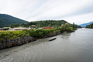
Gitwinksihlkw formerly Canyon City, is a Nisga'a Village in the Nass River valley of northwestern British Columbia, Canada, near that river's confluence with the Tseax River. An older spelling is Kitwilluchsilt. It is one of four Nisga'a villages. Road access is via the Nisga'a Highway.

Observatory Inlet is an inlet on the North Coast of British Columbia. It is a northward extension of Portland Inlet, other branches of which include the Portland Canal. The entrance of Observatory Inlet, from Portland Inlet, lies between Ramsden Point and Nass Point. Ramsden Point also marks, to the west, the entrance of Portland Canal. Observatory Inlet was named by George Vancouver in 1793, because he set up his observatory on the shore of the inlet, at Salmon Cove, in order to calibrate his chronometers. His two vessels, HMS Discovery and HMS Chatham, stayed in Salmon Cove from July 23 to August 17, 1793. During this time a boat surveying expedition under Vancouver himself explored Behm Canal. Vancouver also named three headlands at the entrance of Observatory Inlet: Maskelyne Point, for Nevil Maskelyne, the Astronomer Royal, Wales Point, for William Wales, the mathematical master who sailed with James Cook, and Ramsden Point, after the famed mathematical instrument-maker Jesse Ramsden.

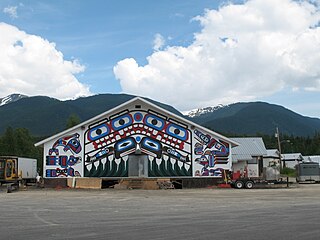
The Nisg̱aʼa Museum is a museum of the Nisg̱aʼa people that is located in Lax̱g̱altsʼap, a village in northwestern British Columbia, Canada. The Nisg̱aʼa name means "the heart of Nisg̱aʼa House crests," a name that celebrates the role of tribal crests in Nisg̱aʼa society. The museum is a project of the Nisg̱aʼa Lisims Government and opened in the spring of 2011. It is a place for display of Nisg̱aʼa artifacts, sharing traditions and ideas, and a centre for research and learning. The museum's collection of Nisg̱aʼa culture is "one of the preeminent collections of Northwest Coast aboriginal art" The museum's website states: "This is our gift to each other, our fellow Canadians and the world."

The Bell-Irving River is a tributary of the Nass River in northwestern British Columbia, Canada. It originates in the Sacred Headwaters region, and flows about 165 km (103 mi) south to the Nass River. It course lies between the Oweegee Range of the Skeena Mountains to the east and the Boundary Ranges of the Coast Mountains to the west.
