Arthur Land District is one of the twenty land districts of Tasmania, which form part of the state's cadastral land division system. It was formerly known as **Arthur County**, one of the 18 historic counties of Tasmania established during the 19th century for land title and administrative purposes.[1]
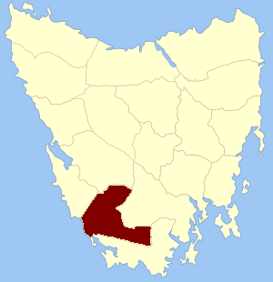
Arthur Land District is located in south-western Tasmania. It is bordered by the Gordon River to the north-west, the Huon River to the north-east, and the Picton River to the east.[2]
The district includes the Arthur Range, a series of rugged mountains that form part of Tasmania’s remote wilderness area.[3]
It is neighboured by the land districts of Montgomery to the west and north-west, Franklin to the north, and Buckingham to the north-east. To the east and south-east lies Kent, while the southern and south-western boundaries meet the Southern Ocean.[1]
Arthur was originally proclaimed as one of the 18 counties of Tasmania during the 1800s under British colonial administration. With the reorganisation of cadastral boundaries in the early 20th century, the counties were replaced by **land districts**, which remain the legal framework for land titling and property boundaries today.[4]
↑ Prescott, J. R. V. (1987). The Geography of Frontiers and Boundaries. Hutchinson University Library. p.144.
This page is based on this Wikipedia article Text is available under the CC BY-SA 4.0 license; additional terms may apply. Images, videos and audio are available under their respective licenses.