
The Democratic Republic of the Congo (DRC), also known as Congo-Kinshasa and formerly known as Zaire, is a country in Central Africa bordered to the west by the South Atlantic Ocean. By land area, the DRC is the second-largest country in Africa and the 11th-largest in the world. With a population of around 112 million, the Democratic Republic of the Congo is the most populous officially Francophone country in the world. The national capital and largest city is Kinshasa, which is also the nation's economic center. The country is bordered by the Republic of the Congo, Central African Republic, South Sudan, Uganda, Rwanda, Burundi, Tanzania, Zambia, Angola, and the Cabinda exclave of Angola.
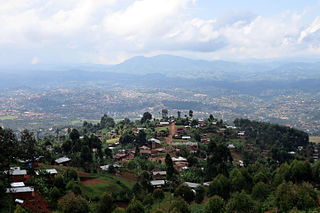
Butembo is a city in North Kivu, in the north eastern Democratic Republic of Congo, lying west of the Virunga National Park. The city is an important commercial centre with large markets, a cathedral, multiple large hospitals, and an airport. The city is located in a region known for tea and coffee growing. As of 2013 it had an estimated population of 670,285, making it the second largest city in North Kivu.
Kisantu, is a town in the western Democratic Republic of Congo, lying south west of Kinshasa, on the Inkisi River. It is known for its large cathedral and for its botanical gardens, which include an arboretum of indigenous trees.
Arua is a city and commercial centre within the Arua District in the Northern Region of Uganda.

Masina is a municipality (commune) in the Tshangu district of Kinshasa, the capital city of the Democratic Republic of the Congo.
Bugiri is a town in the Eastern Region of Uganda. It is the chief town of Bugiri District, and the district headquarters are located there. The town was elevated to Municipal Council status in 2019.
Koboko is a town in Northern Region of Uganda. It is the main municipal, administrative, and commercial centre of Koboko District. Koboko is also the hometown of former dictator Idi Amin who ruled Uganda between 1971 and 1979.
Gemena Airport is an airport serving Gemena, the capital of the Sud-Ubangi District in Sud-Ubangi province in the Democratic Republic of the Congo.

Kananga Airport is an airport serving Kananga, Democratic Republic of the Congo.
Muanda Airport or Moanda Airport is an airport serving Muanda, an Atlantic coastal city in the Democratic Republic of the Congo.
N'Dolo Airport, also known as Ndolo Airport, is a secondary airport in the city of Kinshasa, Democratic Republic of the Congo, located in the commune of Barumbu near the city center.
Kamina Airport is an airport serving Kamina, a city in Haut-Lomami Province, Democratic Republic of the Congo.
Paidha is a town in the Northern Region of Uganda.
Mpondwe is a town in the Western Region of Uganda.
Rwimi is a town in Bunyangabu District in the Western Region of Uganda. With an estimated population of 16,200 in 2020 it is the largest urban center in the district, but the district headquarters are located elsewhere; in Kibiito.

Maracha District is a district in the West Nile sub-region, in the Northern Region of Uganda. It was formed in 2006 from Arua District.

The M'pozo is a river in the province of Bas-Congo in the Democratic Republic of the Congo. Its source is located in Angola and it forms part of the Angola–Democratic Republic of the Congo border. The river ends on the left bank of the Congo River, a few kilometres upstream of Matadi.
Vurra is a town in Uganda.
Vurra–Arua–Koboko–Oraba Road is a road in the Northern Region of Uganda, connecting the town of Vurra at the International border with the Democratic Republic of the Congo with the city of Arua, the town of Koboko, and the town of Oraba at the International border with the Republic of South Sudan.
Bwera General Hospital, also Bwera Hospital, is a hospital in the Western Region of Uganda.
