This article relies largely or entirely on a single source .(February 2024) |
Arundavapuram is a large village located in Ammapettai block, Papanasam Taluk, Thanjavur District, India.
This article relies largely or entirely on a single source .(February 2024) |
Arundavapuram is a large village located in Ammapettai block, Papanasam Taluk, Thanjavur District, India.
Arundavapuram had a total of 651 houses, and a population of 2,603 according to the 2011 census of India. [1] The literacy rate was 73.01% compared to 80.09% for Tamil Nadu.
Arundavapuram is located 22.2km away from district capital Thanjavur;5.2km away from revenue block capital Ammapettai;7km from Saliyamangalam;9.1km from Needamangalam
Thanjavur Air Force Station is the nearest airport to Arundavapuram. It is 24.8 km from Arundavapuram, but the main airport is the Karaikal Airport 58.4 km distance away.
Nagapattinam beach is the nearest beach, 56.7|km away from Arundavapuram. The other beaches nearby are Velankanni beach – 57.5 kilometres (35.7 mi) and Karaikal beach – 60 kilometres (37 mi).

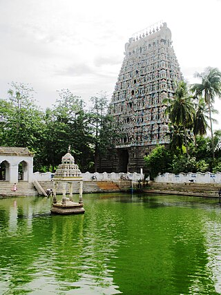
Thanjavur, also known as Thanjai, previously known as Tanjore, is a city in the Indian state of Tamil Nadu. It is the 11th biggest city in Tamil Nadu. Thanjavur is an important center of southern Indian religion, art, and architecture. Most of the Great Living Chola Temples, which are UNESCO World Heritage Monuments, are located in and around Thanjavur. The foremost among these, the Brihadeeswara Temple, built by the Chola emperor Rajaraja I, is located in the centre of the city. This temple has one of the largest bull statue in India carved out of a single granite rock called Nandi. Thanjavur is also home to Tanjore painting, a painting style unique to the region. Thanjavur is the headquarters of the Thanjavur District. The city is an important agricultural centre located in the Kaveri Delta and is known as the Rice bowl of Tamil Nadu. Thanjavur is administered by a municipal corporation covering an area of 36.31 km2 (14.02 sq mi) and had a population of 222,943. Roadways are the major means of transportation, while the city also has rail connectivity. The nearest airport is Tiruchirapalli International Airport, located 59.6 km (37.0 mi) away from the city. The nearest seaport is Karaikal, which is 94 km (58 mi) away from Thanjavur. The city first rose to prominence during the reign of the Cholas when it served as the capital of the empire. After the fall of the Cholas, the city was ruled by various dynasties such as the Mutharaiyar dynasty, the Pandyas, the Vijayanagar Empire, the Madurai Nayaks, the Thanjavur Nayaks, the Thanjavur Marathas and the British Empire. It has been a part of independent India since 1947.
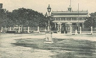
Mayiladuthurai is a town and district headquarter of Mayiladuthurai district in Tamil Nadu, India. The town is located at a distance of 256 km (159 mi) from the state capital, Chennai.
Karaikal is a town of the Indian Union Territory of Puducherry. Karaikal was sold to the French by the Rajah of Thanjavur and became a French Colony in 1739. The French held control, with occasional interruptions from the British, until 1954, when it was de facto incorporated into the Republic of India, along with Mahé, Yanaon, and Pondichéry.

Mannargudi is a town in Thiruvarur district in the Indian state of Tamil Nadu. It is the headquarters of the Mannargudi taluk. The town is located at a distance of 28 km (17 mi) from the district headquarters Thiruvarur, 36 km from Kumbakonam, 40 km from Thanjavur and 310 km (190 mi) from the state capital Chennai. Mannargudi is known for the Rajagopalaswamy temple, a prominent Vaishnavite shrine.
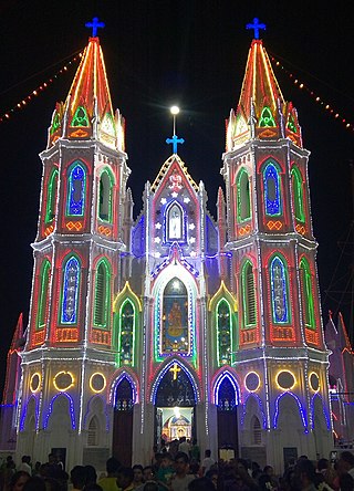
Velankanni (Vēḷāṅkaṇṇi), is a Special Grade Panchayat Town in Nagapattinam district in the Indian state of Tamil Nadu. It lies on the Coromandel Coast of the Bay of Bengal, 350 km south of Chennai (Madras), 12 km south of Nagapattinam, and 33 km southeast of Thiruvarur.

Neyveli is an industrial town in the Cuddalore district in the Indian state of Tamil Nadu. It is located 62 kilometres (39 mi) inland from the Bay of Bengal, west of Pondicherry and 197 kilometres (122 mi) south of Chennai. The town was developed in 1956 after the establishment of Neyveli Lignite Corporation, a public sector enterprise.

Papanasam is a panchayat town in Thanjavur district in the Indian state of Tamil Nadu. It is located 25 kilometres (16 mi) from Thanjavur and 15 kilometres (9.3 mi) from Kumbakonam. The name literally translates to "Destruction of Sins" in the Tamil language. It is the suburban region of Kumbakonam.

Ariyalur is a town and district headquarters of Ariyalur district in the South Indian state of Tamil Nadu and is rich in limestone, surrounded with seven cement factories and two sugar factories. The town is located at a distance of 310 km (190 mi) from the state capital Chennai.

Ayyampettai is a panchayat town in Thanjavur district in the state of Tamil Nadu, India. It is located 15 km from Thanjavur and 24 km from Kumbakonam.
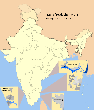
Karaikal district is one of the four districts of the Union Territory of Puducherry in India.

Viluppuram, Villupuram, or Vizhuppuram is a Municipality and the administrative headquarters of Viluppuram district.
Saliyamangalam is a village in the Papanasam taluk of Thanjavur district, Tamil Nadu, India. It is one of the two places in Tamil Nadu where the Bhagavathar Melas are held, the other being Melattur.
Kottaipattinam is a village panchayat located in the Pudukkottai district of Tamil Nadu state, India. The latitude 9.97908 and longitude 79.198595 are the geocoordinate of the Kottaipattinam. The Kottaipattinam Population is 13454. Male is 6668. Female is 6786.

Koothanallur is a town in Tiruvarur district in the South Indian state of Tamil Nadu. The town is located at a distance of 20 km (12 mi) from the district headquarters Tiruvarur and 350 km (220 mi) from the state capital Chennai. Koothanallur is known for the Big Pallivasal. Sri Ramanatha Swamy Thirukovil, an ancient temple at Tirurameshwaram, is located 7 km (4.3 mi) far to Koothanallur, southerly.
Mayiladuthurai Junction is a junction railway station serving the town of Mayiladuthurai in Mayiladuthurai District of Tamil Nadu, India.

Thiruvarur Junction is a junction railway station serving Thiruvarur town, headquarters of Thiruvarur district in Tamil Nadu in India and a focal point on the branch line connecting trains from Chennai to Nagapattinam–Velankanni–Nagore–Karaikal on one line and Karaikkudi–Sivganga–Manamadurai–Rameswaram on the second line and Tiruchirappalli–Thanjavur–Thiruvarur–Nagapattinam–Karaikal on the third line and Mayiladuthurai–Thiruvarur on the fourth line that branches out of the station.
Palaiyur is a village within the Indian state of Tamil Nadu. Palaiyur is located 282 kilometers from Chennai, in Kuttalam Taluk, which is in the Mayiladuthurai district and shares close border with the Thanjavur district. The current population is just under 2,000. Nearby villages include: Peravoor, Nakkambadi,S.Pudur, Kokkur, and Srikandapuram.
Nagapattinam Junction is a junction railway station serving the town of Nagapattinam in Tamil Nadu, India.

Kalathur is a panchayat village in Peravurani panchayat Union of Thanjavur district in the Indian state of Tamil Nadu. Kalathur is a part of the Pattukkottai taluk of Thanjavur district and located 67 kilometres (42 mi) south of Thanjavur connected via State Highway 29.
Vishnampettai is a large village in Budalur block, Thiruvaiyaru taluk of Thanjavur district, Tamil Nadu. This village is located in the banks of Kaveri River, Kollidam River and Kudamurutti River.
10°45′N79°19′E / 10.750°N 79.317°E
| | This Thanjavur district location article is a stub. You can help Wikipedia by expanding it. |