
Arusha City is a Tanzanian city, with a population of 617,631, and the regional capital of the Arusha Region, with a population of 2,356,255.

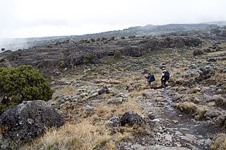
Moshi is a municipality and the capital of Kilimanjaro region in the north eastern Tanzania. As of 2017, the municipality has an estimated population of 201,150 and a population density of 3,409 persons per km2. In the last official census of 2022, the municipality had a population of 221,733. The municipality is situated on the lower slopes of Mount Kilimanjaro, a dormant volcano that is the highest mountain in Africa. The name Moshi has been reported to refer to the smoke that emanates from the nearby mountain. The municipality covers about 59 square kilometres (23 sq mi) and is the smallest municipality in Tanzania by area.

Marangu is a town located in Moshi District of Kilimanjaro Region. it is divided into Marangu East and Marangu west, each with its own village. It is recognized as one of the main gates for climbing Mount Kilimanjaro. it is also famous for being the place where Mangi mkuu of the Chagga Thomas Lenana Marreale was born on June 15, 1915.
Arusha Region is one of Tanzania's 31 administrative regions and is located in the northeast of the country. The region's capital and largest city is the city of Arusha. The region is bordered by Kajiado County and Narok County in Kenya to the north, the Kilimanjaro Region to the east, the Manyara and Singida Regions to the south, and the Mara and Simiyu regions to the west. Arusha Region is home to Ngorongoro Conservation Area, a UNESCO World Heritage Site. The region is comparable in size to the combined land and water areas of the state of Maryland in the United States.

United World College East Africa (UWCEA) is an independent international school in Tanzania, and a member of the United World Colleges movement. Established in 1969 as International School Moshi, the school is based on two campuses on the slopes of Mount Kilimanjaro and Mount Meru near the city of Moshi, the capital of the Kilimanjaro region in north eastern Tanzania.
Arusha City Council is one of seven administrative districts of Arusha Region in Tanzania. It is surrounded to the south, west and north by Arusha Rural District and to east by Meru District. The district covers an area of 267.0 km2 (103.1 sq mi). The district is comparable in size to the land area of Cayman Islands. The district capital is the city of Arusha. As of 1994, Arusha District was the wealthiest district in Tanzania. According to the 2022 Tanzania National Census, the population of Arusha Urban District was 617,631.

Arumeru District is a former district in the Arusha Region of Tanzania. It was bordered to the north, west, and southwest by Monduli District, to the southeast by the city of Arusha, and to the east by the Kilimanjaro Region.

Ngorongoro District is one of seven districts in western Arusha Region of Tanzania. The district is bordered to the north by Kenya, to the east by Monduli District, the northeast by Longido District, and to the south by the Karatu District. The western border is the Serengeti District in Mara Region. Ngorongoro District is home to the Ngorongoro Crater and was named after it. It covers an area of 14,036 km2 (5,419 sq mi). The district is comparable in size to the land area of Timor Leste. The administrative seat is the town of Loliondo. The district is home to the Ngorongoro Conservation Area which is a UNESCO World Heritage Site. The district is also home to the third tallest mountain in the country, Mount Loolmalasin. According to the 2002 Tanzania National Census, the population of the Ngorongoro Region was 129,776. By 2012, the population of the district was 174,278. By 2022, the population had grown to 273,549.

Hai is one of the seven districts of the Kilimanjaro Region of Tanzania.The district covers approximately 1,217 square kilometres (470 sq mi). It is bordered to the southwest by the Meru District of Arusha Region, to the west by the Siha District, and to the east by the Moshi Urban District and Moshi Rural District and the Rombo District to the far north. The western breach part of Mount Kilimanjaro is located in the Hai District. According to the 2022 census, the population of the Hai District was 240,999.

Nyumba ya Mungu Dam is a Tanzanian, hydroelectric dam located in and operated in Mwanga District, Kilimanjaro Region. It was built in the late 1960s and is Kilimanjaro region's largest artificial water body. Nyumba ya Mungu Reservoir. The reservoir is shared with Moshi District of Kilimanjaro Region and Simanjiro District of Manyara Region. Nyumba ya Mungu means 'House of God'. Its installed capacity is 8 megawatts (11,000 hp).

The Arusha people are a Bantu ethnic and indigenous group based in the western slopes of mount Meru in Arusha District of Arusha Region in Tanzania. The Maasai regard the Arusha people as related as they were once a part of the immigrant Maasai whom arrived in Arusha in the late 18th century from Kenya. The Arusha people are not to be confused by Arusha residents who are a mix of people of different ethnic backgrounds that are born and reside within the borders of the Arusha Region.

Meru District, officially the Meru District Council is one of seven districts of the Arusha Region of Tanzania.The District is bordered to the north by Longido District, to the east by Siha and Hai Districts of Kilimanjaro Region, to the south by Simanjiro District of Manyara Region, and to the west by Arusha Rural District and Arusha Urban District. It covers an area of 1,266 km2 (489 sq mi). The district is comparable in size to the land area of Faroe Islands. Meru District has an max elevation of 3,800 m (12,500 ft) at Rhino Point on Mount Meru. The administrative capital of the district is Usa River. According to the 2022 Tanzania National Census, the population of Meru District council was 331,603.

The following outline is provided as an overview of and topical guide to Tanzania:
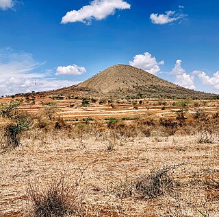
Mateves is a Tanzanian administrative ward located in Arusha Rural District of the Arusha Region. It is one of 21 administrative wards in the district. Mateves means places where the fever tree grows in the Maasai language. Mateves ward is bordered by Musa ward to the northwest, Oltrumet ward to the far northeast, a tip of the Olorieni ward to the northeast as well. Olasiti ward borders Mateves to the north east and Terrat to the south east. To the south of Mateves is Oljoro ward and the southwest of Mateves is the Moita Ward and lastly, towards the west is Kisongo ward. The small town of Ngorbob is the seat of the ward. The ward is home to the Mungu Crater and Loljoro Hill at 1,585 meters. The ward covers an area of 104.4 km2 (40.3 sq mi), and has an elevation of 1,328 m (4,357 ft). According to the 2012 census, the ward had a total population of 15,632
Hai Mjini is an administrative ward in Hai District of Kilimanjaro Region in Tanzania. The ward covers an area of 54 km2 (21 sq mi), and has an average elevation of 1,388 m (4,554 ft). According to the 2012 census, the ward has a total population of 34,098.
University of Arusha (UoA) is a chartered Tanzanian, private Christian university based in Usa River, Arumeru District, Arusha Region. It is owned and operated by the Seventh-day Adventist Church. It is a part of the Seventh-day Adventist education system, the world's second largest Christian school system.
Siha is one of the seven administrative districts of Kilimanjaro Region in Tanzania. The district covers approximately 1,217 square kilometres (470 sq mi). It is bordered to the west by Meru District in Arusha Region and to the northeast by Rombo District and the southeast Hai District. The western part of Mount Kilimanjaro is located within the district's boundaries.

Arusha District or Arusha District Council is one of the seven districts of the Arusha Region of Tanzania. The district is bordered to the north by Longido District, to the east by Meru District, to the south by Kilimanjaro Region, and to the west by Monduli District. the district surrounds Arusha City on all three sides. The district covers an area of 1,547.6 km2 (597.5 sq mi). The district is comparable in size to the land area of Guadeloupe. The district capital is located in Sokon II. According to the 2022 Tanzania National Census, the population of Arusha District was 449,518.
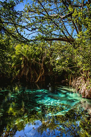
Kikuletwa Hot Springs, also known as Maji Moto(Maji Moto ya Kikuletwa in Swahili) and also Chemka Hot Springs, is a natural geothermal oasis located in Masama Rundugai ward of Hai District in the Kilimanjaro region of Tanzania. Chemka means "boiling" in Swahili, referring to the appearance of how the water emerges from the ground. The hot springs are located approximately 40 kilometers from the town of Moshi, which is a gateway to Mount Kilimanjaro in a village called Chemka. The hot spring waters flow into the Kikuletwa River and eventually find its way to the Pangani River.
