
Arusha City is a Tanzanian city, with a population of 617,631, and the regional capital of the Arusha Region, with a population of 2,356,255.

Dodoma Region is one of Tanzania's 31 administrative regions. The regional capital is the city of Dodoma. Dodoma is located in central Tanzania, bordered by Singida region to the west, Manyara region to the north, Iringa region to the south, and Morogoro region to the east. Dodoma region hosts the nation's capital city, where the legislative assembly of Bunge is based. Dodoma region also hosts one of the largest universities in Tanzania: University of Dodoma. The region is the home of the Tanzanian wine industry, which is the second largest wine industry on the continent after South Africa. According to the 2022 national census, the region had a population of 3,085,625; in the 2012 national census, the population was 2,083,588.
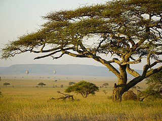
Mara Region is one of Tanzania's 31 administrative regions. The region covers an area of 21,760 km2 (8,400 sq mi). The region is comparable in size to the combined land area of the nation state of El Salvador. The neighboring regions are Mwanza Region and Simiyu Region, Arusha Region, and Kagera Region. The Mara Region borders Kenya .The regional capital is the municipality of Musoma. Mara Region is known for being the home of Serengeti National Park, a UNESCO World Heritage site and also the birth place of Tanzania's founding father Julius Nyerere. Under British colonial occupation, the Mara Region was a district called the Lake Province, which became the Lake Region after independence in 1961.
Arusha Region is one of Tanzania's 31 administrative regions and is located in the northeast of the country. The region's capital and largest city is the city of Arusha. The region is bordered by Kajiado County and Narok County in Kenya to the north, the Kilimanjaro Region to the east, the Manyara and Singida Regions to the south, and the Mara and Simiyu regions to the west. Arusha Region is home to Ngorongoro Conservation Area, a UNESCO World Heritage Site. The region is comparable in size to the combined land and water areas of the state of Maryland in the United States.

Mwanza Region is one of Tanzania's 31 administrative regions. The region covers a land area of 25,233 km2 (9,743 sq mi). The region is comparable in size to the combined land area of the nation state of North Macedonia. Mwanza Region is bordered to the north through Lake Victoria by the Kagera Region and Mara Region, to the east by Simiyu Region, to the south by the Shinyanga Region and to the west by Geita Region. The regional capital is the city of Mwanza. According to the 2022 national census, the region had a population of 3,699,872 and national census of 2012 had 2,772,509. Mwanza Region is the second region with high population in Tanzania after Dar es Salaam Region.

Karatu District is one of seven districts of the Arusha Region of Tanzania. The district is bordered to the north by the Ngorongoro District and to the west by the Meatu District in the Simiyu Region. The district is bordered to the east by the Monduli District, and to the south and southeast by the Mbulu District and the Babati District. The district covers an area of 3,207 km2 (1,238 sq mi). The district is comparable in size to the land area of Samoa. The district has an max elevation of 1,739 m (5,705 ft) on Oldeani Peak. Karatu district is home to the hunter-gatherer community of the Hadza people. Also Karatu is known agriculturally as the onion capital of Tanzania. The district capital is the town of Karatu. According to the 2022 census, the population of the district was 280,454.
Arusha City Council is one of seven administrative districts of Arusha Region in Tanzania. It is surrounded to the south, west and north by Arusha Rural District and to east by Meru District. The district covers an area of 267.0 km2 (103.1 sq mi). The district is comparable in size to the land area of Cayman Islands. The district capital is the city of Arusha. As of 1994, Arusha District was the wealthiest district in Tanzania. According to the 2022 Tanzania National Census, the population of Arusha Urban District was 617,631.

Usa River also known locally as Ussa is an administrative ward of the Meru District in the Arusha Region of Tanzania. It is the seat of Meru District. To the north and west, the ward is surrounded by the wards of Nkoaranga, Poli, and Seela Sing'isi. To the south and east, respectively, are the wards of Kikwe and Maroroni, and Maji ya Chai. As of 2012, Usa River ward had a population of 23,437.

The Arusha people are a Bantu ethnic and indigenous group based in the western slopes of mount Meru in Arusha District of Arusha Region in Tanzania. The Maasai regard the Arusha people as related as they were once a part of the immigrant Maasai whom arrived in Arusha in the late 18th century from Kenya. The Arusha people are not to be confused by Arusha residents who are a mix of people of different ethnic backgrounds that are born and reside within the borders of the Arusha Region.

Meru District, officially the Meru District Council is one of seven districts of the Arusha Region of Tanzania.The District is bordered to the north by Longido District, to the east by Siha and Hai Districts of Kilimanjaro Region, to the south by Simanjiro District of Manyara Region, and to the west by Arusha Rural District and Arusha Urban District. It covers an area of 1,266 km2 (489 sq mi). The district is comparable in size to the land area of Faroe Islands. Meru District has an max elevation of 3,800 m (12,500 ft) at Rhino Point on Mount Meru. The administrative capital of the district is Usa River. According to the 2022 Tanzania National Census, the population of Meru District council was 331,603.
Maji ya Chai is an administrative ward in the Meru District of the Arusha Region of Tanzania. The ward is home to the University of Arusha is also where the gate of Arusha National Park is located. According to the 2012 census, the ward has a total population of 29,313. Thus making the ward the most populous in Meru district.
Moivo is an administrative ward in the Arumeru district of the Arusha Region of Tanzania. According to the 2002 census, the ward has a total population of 20,562. The ward is the second most populous ward in the district after Sokon II.
Murieti was an administrative ward in the Arumeru district of the Arusha Region of Tanzania. With the dissolution of the Arumeru District in 2007 it has become part of the Terrat Ward in the Arusha Municipal district. According to the 2002 census, the ward has a total population of 18,188.
Musa is an administrative ward in the Arumeru district of the Arusha Region of Tanzania. The district and ward were dissolved in 2007 becoming parts of the Arusha and Meru districts.
Nduruma, is a administrative ward in Arusha Rural District in the east Arusha Region of Tanzania. It is bordered to the north by Mlangarini, to the south by Bwawani, and to the east by Kikwe ward of the Meru District. The ward covers an area of 62.72 square kilometres (24.22 sq mi) with an average elevation of 1,041 metres (3,415 ft).

Sekei is an administrative ward and district capital located in the Arusha City Council of Arusha Region in Tanzania. The ward is bordered by Kaloleni ward to the west, Sokon II ward to the north, Kimandolu ward to the east, Themi to the south and, a tiny portion of Kati ward to the southeast. The name sekei comes from the Masai word seki which is a type of tree that grew there before settlement. Sekei ward was officially established in 1969 and is the location of the headquarters of Arusha City Council.

Longido District is one of seven districts of the Arusha Region of Tanzania. The district is bordered to the east by the Ngorongoro District, to the south west by the Monduli District and southeast by the Arusha Rural District and Meru District. To the far east by Siha District of Kilimanjaro Region and the north by Kenya. It covers an area of 7,885 km2 (3,044 sq mi). The district is comparable in size to the land area of Puerto Rico.Longido District was created in 2007 from Monduli District. Mount Longido, Gelai and Kitumbeine volcano are all located within the boundaries of the district. The administrative seat is the town of Longido. According to the 2022 census, the population of the district was 175,915. Longido District is known as Arusha's gem district, as it is home to Anyolite and Rubies.

Arusha District or Arusha District Council is one of the seven districts of the Arusha Region of Tanzania. The district is bordered to the north by Longido District, to the east by Meru District, to the south by Kilimanjaro Region, and to the west by Monduli District. the district surrounds Arusha City on all three sides. The district covers an area of 1,547.6 km2 (597.5 sq mi). The district is comparable in size to the land area of Guadeloupe. The district capital is located in Sokon II. According to the 2022 Tanzania National Census, the population of Arusha District was 449,518.

Arusha Technical College (ATC) is a Tanzanian college, with its main campus located inside Ngarenaro ward, in the city of Arusha, Arusha Region. ATC is one of the largest and well established public coeducational post-secondary tertiary education institutions in Arusha Region. The college has three campuses: Main Campus in Arusha City, the second campus in located in Oljoro ward in Arumeru District, Arusha Region. The third campus is located in the small town Kikuletwa in Hai District, Kilimanjaro.

Sokon II is one of the 27 administrative wards of the Arusha District Council located in the Arusha Region of Tanzania. The name Sokon comes from the Swahili word for market, sokoni. The ward shares a similar name with another ward located in Arusha Urban District called Sokon I and the former is one of 27 rural administrative wards in the district as of 2012. Sokon II ward is bordered by Oltoroto and Moivo ward in the west, Ilkiding'a ward to the north, Bangata ward to the east. On the southern border Sokon II is bordered by Baraa, Kimandolu and Sekei wards. According to the 2012 census, the ward has a total population of 32,073. Thus, Sokon II is the most populous ward in Arusha District. Also the ward headquarters are Oldadai village. In addition, the Arusha District Administration building is located in Sokon II ward.
