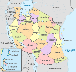
Rukwa Region is one of Tanzania's 31 administrative regions with a postcode number 55000. The regional capital is the municipality of Sumbawanga. According to the 2012 national census, the region had a population of 1,004,539. For 2002–2012, the region's 3.2 percent average annual population growth rate was tied for the third highest in the country. It was also the twentieth most densely populated region with 44 people per square kilometer.

Unguja North Region is one of the 31 regions of Tanzania. Located on the island of Zanzibar, Mkokotoni serves as the region's capital. Zanzibar North is divided into two districts, Kaskazini A and Kaskazini B.

Kinondoni District is one of the district in Dar es Salaam, Tanzania, others being Temeke, Kigamboni, Ubungo and Ilala. To the east is the Indian Ocean, to the north and west the Pwani Region of Tanzania. The area of Kinondoni is 537 km2 (207 sq mi).

Temeke District is on of five district in Dar es Salaam, Tanzania, with Kinondoni to the far north of the city, and Ilala in the downtown of Dar es Salaam. To the east is the Indian Ocean and to the south and west is the coastal region of Tanzania. The 2012 Tanzania National Census reported that the population of Temeke District was 1,368,881. The area is 729 km².

Ilala District is one of five districts in Dar es Salaam, Tanzania, the others being Temeke to the South and Kinondoni to the North and Ubungo to the northwest. The 2012 National Tanzania Census states the population for Ilala as 1,220,611.

Magu District is one of the seven districts of the Mwanza Region of Tanzania, East Africa. Its administrative centre is the town of Magu on the Simiyu River. It is bordered to the north by Lake Victoria and Busega District, to the east by Bariadi District, to the south by Itilima District, Maswa District, Kwimba District and Misungwi District, and to the west by the city of Mwanza, which consists of Nyamagana District and Ilemela District.

Rungwe is a District in Mbeya Region, Tanzania. It is bordered to the north by Mbeya Rural District, to the east by Iringa Region, to the southeast by Kyela District, to the southwest by Ileje District and to the west by Mbeya District.

Mateves is a Tanzanian administrative ward located in Arusha Rural District of the Arusha Region. It is one of 21 administrative wards in the district. Mateves means places where the fever tree grows in the Maasai language. Mateves ward is bordered by Musa ward to the northwest, Oltrumet ward to the far northeast, a tip of the Olorieni ward to the northeast as well. Olasiti ward borders Mateves to the north east and Terrat to the south east. To the south of Mateves is Oljoro ward and the southwest of Mateves is the Moita Ward and lastly, towards the west is Kisongo ward. The small town of Ngorobob is the seat of the ward. The ward is home to the Mungu Crater and Loljoro Hill at 1,585 meters. The ward covers an area of 104.4 km2 (40.3 sq mi), and has an elevation of 1,328 m (4,357 ft). According to the 2012 census, the ward had a total population of 15,632

Moshono is an administrative ward located in Arusha District, Arusha Region of Tanzania. It is one of 19 urban administrative wards in the municipality. Moshono ward is bordered by four wards to the north namely; Bangata, Baraa and Nkoanrua. Moshono is bordered to the west by Olorein, Themi and Engutoto wards. The ward of Mlangarini borders Moshono to the east. Moshono ward is the third largest ward in Arusha Urban District thus its mostly a rural ward with many farming communities and large schools. The ward covers an area of 24.59 km2 (9.49 sq mi), and has an elevation of 1,348 m (4,423 ft). According to the 2012 census, the ward had a total population of 20,698

Oltroto or also spelt as Oltoroto is a Tanzanian administrative ward located in Arusha Rural District of the Arusha Region. Oltoroto means a place to collect chalk in Maasai language. The ward is bordered by Ilkiding'a to the north, Sokon II to the east, Moivo to the south and finally Olorieni and Kiranyi wards to the west. The ward is home to plateu mountain called Oldonyo Sapuk and on the east of the ward is Kivesi Hill at 1,897 meters tall. The ward covers an area of 11.85 km2 (4.58 sq mi), and has an average elevation of 1,699 m (5,574 ft). According to the 2012 census, the ward had a total population of 15,451

Elerai is an administrative ward in Arusha District, Arusha Region of Tanzania. It is one of 19 urban administrative wards in the municipality. The ward is bordered by Olasiti ward to the west, Kiranyi ward to the north, Ngarenaro ward to the east, Sombetini to the south and, a tiny portion of Unga L.T.D ward to the southeast. The ward covers an area of 3.746 km2 and ranks number eleven in the area in Arusha city. The ward is home to the national National College of Tourism, the African Court and Tanzania National Parks Authority (TANAPA)'s national headquarters, also the Arusha Modern school. The school's famous alumna is Tanzanian recording artist, Vanessa Mdee, who received secondary education there. According to the 2012 census, the ward had a total population of 40,749.

Sombetini is an administrative ward located in Arusha District, Arusha Region of Tanzania. It is one of 19 urban administrative wards in the municipality. Sombetini ward is bordered by Elerai ward to the north, Unga L.T.D and Sokon I wards to the east. The wards of Olasiti and Terrat are located in to west and south respectively. Sombetini ward is home to Aim Mall and Arusha City Goat Market. The ward covers an area of 5.173 km2 (1.997 sq mi), and has an elevation of 1,348 m (4,423 ft). According to the 2012 census, the ward had a total population of 48,268.

Kigamboni is one of the district of Dar es Salaam, Tanzania.

The administrative divisions of Tanzania are controlled by Part I, Article 2.2 of the Constitution of Tanzania. Tanzania is divided into thirty-one regions. Each region is subdivided into districts. The districts are sub-divided into divisions and further into local wards. Wards are further subdivided for management purposes: for urban wards into streets and for rural wards into villages. The villages may be further subdivided into hamlets.

Songoro is an administrative ward in the Meru District of the Arusha Region of Tanzania. The ward covers an area of 114.0 km2 (44.0 sq mi), and has an average elevation of 1,285 m (4,216 ft). According to the 2012 census, the ward has a total population of 11,139.

Mussa is an administrative ward in the Arusha Rural District of the Arusha Region of Tanzania. The ward covers an area of 71.60 km2 (27.64 sq mi), and has an average elevation of 1,571 m (5,154 ft). According to the 2012 census, the ward has a total population of 11,836.

Iloirienito is an administrative ward in the Longido District of the Arusha Region of Tanzania. The ward covers an area of 140.1 km2 (54.1 sq mi), and has an average elevation of 1,610 m (5,280 ft). According to the 2012 census, the ward has a total population of 5,571.

Mundarara is an administrative ward in the Longido District of the Arusha Region of Tanzania. The ward covers an area of 614.4 km2 (237.2 sq mi), and has an average elevation of 1,458 m (4,783 ft). According to the 2012 census, the ward has a total population of 7,301. the mineral Anyolite was first discovered there.

Orbomba is an administrative ward in the Longido District of the Arusha Region of Tanzania. The ward covers an area of 630.0 km2 (243.2 sq mi), and has an average elevation of 1,463 m (4,800 ft). According to the 2012 census, the ward has a total population of 7,900.

Lepurko is an administrative ward in the Monduli District of the Arusha Region of Tanzania. The ward covers an area of 246.8 km2 (95.3 sq mi), and has an average elevation of 1,463 m (4,800 ft). According to the 2012 census, the ward has a total population of 8,151.


