
Arusha Urban District is one of the seven districts of the Arusha Region of Tanzania, and it contains the regional and economic capital; the city of Arusha. It is bordered to the south, west and north by Arusha Rural District and to east by Meru District. As of 1994, Arusha District was the wealthiest district in Tanzania with 91,024 Tanzanian shillings.

Arumeru District is a former district in the Arusha Region of Tanzania. It was bordered to the north, west, and southwest by Monduli District, to the southeast by the city of Arusha, and to the east by the Kilimanjaro Region.

Meru District Council is one of the seven districts councils of the Arusha Region of Tanzania. Meru District council is bordered to the north by Longido District, to the east by Kilimanjaro Region, to the south by Manyara Region, and to the west by Arusha Rural District and Arusha Urban District. The administrative capital of the council is Usa River.
Akheri is an administrative ward in the Meru District district of the Arusha Region of Tanzania. Akheri ward is home to Lake Duluti. The largest settlement in the ward is the town of Tengeru. The ward is also home to Polish refugees WWII Cemetery. According to the 2002 census, the ward has a total population of 12,243.

Kikatiti is an administrative ward in the Meru District of the Arusha Region of Tanzania. According to the 2012 census, the ward has a total population of 16,775.
Leguruki is an administrative ward in the Meru District of the Arusha Region of Tanzania. The ward is home to ober 60 small lakes and is the lake ward of Meru district and also home to the eastern section of Arusha National Park. The ward is bordered to the east by Siha Distric of Kilimanjaro Region. According to the 2002 census, the ward has a total population of 15,678.
Kikwe is an administrative ward in the Meru District of the Arusha Region of Tanzania. According to the 2002 census, the ward has a total population of 9,826.
King'ori is an administrative ward in the Meru District of the Arusha Region of Tanzania. According to the 2002 census, the ward has a total population of 20,670.
Makiba is an administrative ward in the Meru District of the Arusha Region of Tanzania. The ward is bordered by Mererani ward located in Manyara Region which is the only source of Tanzanite on earth. Makiba is a transit ward to Merenani from Arusha Region, the largest importer of the gemstone. According to the 2002 census, the ward has a total population of 12,056.
Maroroni is an administrative ward in the Meru District of the Arusha Region of Tanzania. The ward is home to the privately owned Kilimanjaro Golf and Wildlife sanctuary. According to the 2002 census, the ward has a total population of 12,001.
Mbuguni is an administrative ward in the Meru District of the Arusha Region of Tanzania. The road that goes to Mererani,Manyara Region actually passes through Mbuguni ward. Making Mbuguni a trade route for the Tanzanite gemston. According to the 2002 census, the ward had a total population of 14,880.
Ngarenanyuki is an administrative ward in the Meru District of the Arusha Region of Tanzania. The ward is the largest ward in Meru district. It is located in far north side of the distric. According to the 2002 census, the ward has a total population of 16,988.
Nkoaranga is an administrative ward in the Meru District of the Arusha Region of Tanzania. the ward is home to part of the Arusha National Park, Nkoaranga Hospital and the Ngaresero Lodge. According to the 2002 census, the ward has a total population of 13,338.
Nkoarisambu is an administrative ward in the Meru District of the Arusha Region of Tanzania. The ward is the least populous ward in the distric. According to the 2002 census, the ward has a total population of 6,497.
Poli is an administrative ward in the Meru District district of the Arusha Region of Tanzania. Despite being one of the least populous wards in the district, Poli is home to Tumaini University Makumira and Makumira University College. Both institutions are located in the largest town in the ward, Makumira. According to the 2002 census, the ward has a total population of 8,659.
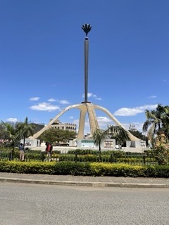
Kati is an administrative ward in the Arusha District of the Arusha Region of Tanzania. Kati means "center" in Swahili language. Kati is one of 19 urban administrative wards in the municipality. The ward is bordered by Levolosi ward to the west, Kaloleni ward to the north, Sekei ward to the northeast, Themi ward to the southeast, Daraja Mbili to the south and, Unga L.T.D ward to the southwest. The ward covers an area of 0.580 km2 (0.224 sq mi) and is the smallest ward in Arusha city. The ward is home to some of the oldest schools in the city and some of the most iconic monuments in the city. Kati is home to the Arusha Friday Mosque, one of the oldest in the city located south of the Arusha Declaration Monument, which is also located in Kati Ward. According to the 2012 census, the ward has a total population of 5,363.
Kimandolu is an administrative ward in the Arusha District of the Arusha Region of Tanzania. It is roughly 6 km from the centre of Arusha town and lies between the Old Moshi Road and the Arusha-Himo highway, which leads directly to Moshi and Kilimanjaro International Airport. There are various charitable NGOs currently working in the area with schools, healthcare and sports, such as Art In Tanzania. The local representative is Jackson Lemunga.
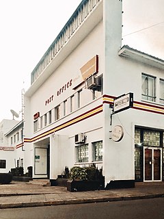
Sekei is an administrative ward located in Arusha District, Arusha Region of Tanzania. It is one of 19 urban administrative wards in the municipality. The name Skeei comes from the Masai word seki which is a type of tree that grew there before settlement. Sekei ward was officially established in 1969. The ward is bordered by Kaloleni ward to the west, Sokon II ward to the north, Kimandolu ward to the east, Themi to the south and, a tiny portion of Kati ward to the southeast. The ward covers an area of 2.643 km2 and ranks number thirteen in the area in Arusha city. The ward is home to the East African Legislative Assembly (EALA), the Arusha International Conference Centre (AICC), and the Arusha National Museum of Natural History. Sekei is the richest ward in the city because of the large international organizations, national, and regional headquarters of various government institutions that are located there. According to the 2012 census, the ward had a total population of 9,213.
Arusha District Council is one of the seven districts of the Arusha Region of Tanzania. It is bordered to the north by Longido District, to the east by Meru District, to the south by Kilimanjaro Region, and to the west by Monduli District. It surrounds Arusha City.

Sokon II is an administrative ward in the Arusha District Council located in the Arusha Region of Tanzania.The name Sokon comes from the Swahili word for market, sokoni. The ward shares a similar name with another ward located in Arusha Urban District called Sokon I and the formeris one of 27 rural administrative wards in the district as of 2012. Sokon II ward is bordered by Oltoroto and Moivo ward in the west, Ilkiding'a ward to the north, Bangata ward to the east. On the southern border Sokon II is bordered by Baraa, Kimandolu and Sekei wards. The ward is home to major foothills of Mount Meru, namely, Kivutu Hill at 1,964 meters tall and Kivesi Hill at 1,897 meters tall and a smaller one named Nariva Hill located at the south side of the ward. According to the 2012 census, the ward has a total population of 32,073. Sokon II is the most populous ward in Arusha Rural District.
