Akwa Ibom State is a state in the South-South geopolitical zone of Nigeria, bordered on the east by Cross River State, on the west by Rivers State and Abia State, and on the south by the Atlantic Ocean. The state takes its name from the Qua Iboe River which bisects the state before flowing into the Bight of Bonny. Akwa Ibom was split from Cross River State in 1987 with its capital Uyo and with 31 local government areas.
Abak is a town and Local Government Area in Akwa Ibom State, Nigeria. The LGA was previously part of Cross River State. It was later sub divided into other local government areas such as Oruk Anam, Etim Ekpo, Ukanafun and Ika. Notable tribes include the Annang. The major economic activities of the people of this area before and after the Nigerian civil war was palm produce exported through river port at Ekpene Okpo, Ntak Ibesit, a distance of about 8 km from Abak town. Abak town, the local government headquarters is located about 18 kilometres from Uyo, the State capital. It has a landmass of 304 square kilometers. Abak to say the least, is the shadow of its former self due to politically motivated neglect by successive governments in Akwa Ibom state. Abak was the economic hub of the former Southeastern Nigeria before the civil war. The Nigerian Army barrack that is popularly known as Ibagwa Barrack is located or can be found in the Abak.
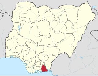
Eket is one of the 31 local government areas in Akwa Ibom State, Nigeria. The name Eket or Ekid also refers to the indigenous ethnic group of the region and to their language. The Eket people use the endonym Ekid for themselves and their language, but Europeans spell and pronounce the name as "Eket".
Oruk Anam is a Local Government Area located in the southwestern part of Akwa Ibom State, Nigeria. It may be ranked as the largest LGA in Akwa-ibom due to its land popularity. Its headquarters are located in the town of Ikot Ibritam. It is one of the eight Annang-speaking local government areas.
Etim Ekpo is a town and Local Government Area in Akwa Ibom State, Nigeria.
Ibiono-Ibom is a Local Government Area of Akwa Ibom State in the south-south region of Nigeria. It has its administrative headquarters at Oko Ita.
Itu is located in the southeast of Nigeria and is a Local Government Area of Akwa Ibom State. The Local Government Area occupies a landmass of approximately 606.1 0 square kilometers. It is bounded in the North and North-East by Odukpani in Cross River State and Arochukwu in Abia State, in the West by Ibiono Ibom and Ikono Local Government Areas, in the South and southeast by Uyo and Uruan Local Government Areas, respectively.
Mbo is located in the South Eastern part of Nigeria and is a Local Government Area in Akwa Ibom State. Following the local government creation exercise of the federal government in 1989 Mbo Local Government Area was carved out of Oron Division same year.
Nsit Ibom is a Nigerian local government area located within central Akwa Ibom State and sharing boundaries with Ibesikpo Asutan, Etinan, Nsit Ubium and Uyo Local Government Areas. The people of Nsit Ibom are of the Ibibio ethnic extraction.
Uruan is located in the south of Nigeria and is a Local Government Area of the Akwa Ibom State.
Ntak Ibesit is a densely populated rural town in Akwa Ibom State of Nigeria. The town was noted for production and trade in palm oil and kernel. In recognition of its strategic importance, the Colonial administration established a river port at Ekpene Okpo, with a colonial court. The court is still in operation today. One of the distinguishing features of Ntak Ibesitt is the network of colonial roads. There is a road linking Ikot Okoro, Mbon Ebre, Ukpom and Ekparakwa- all neighbouring towns and villages. A very popular market in Ntak Ibesit is Urua Ekenyong Obom, which is centrally located to serve Ukpom Edem Inyang, Mbon Ebre, Ediene Ikot Ebom.
Ekparakwa is a town and as well one among the nine clans located in the Oruk Anam local government area of Akwa Ibom State, the southern region of Nigeria.
Urua Anwa is a centrally trading place located in the Oruk Anam local gov't area, the south-eastern region of Akwa Ibom State, Nigeria.
From Uyo to Ikot Nya through Nung Udoe in Ibesikpo-Asutan Local Government Area to Afaha Offiong in Nsit Ibom local government and then Ikot Nya village. Ikot Nya is a sub clan under Mbiaso Clan District in the List of Towns and Villages in Nsit Ubium/Nsit Ibom LGA, Akwa Ibom State, Nigerian. Ikot Nya is a village sharing boundary with Mbiokporo No. ll village in Nsit Ibom Local Government Area, Akwa Ibom State, Nigeria.
Ikot Ukpong is a village in Okon development ward II of Eket local government area, Akwa Ibom State, Nigeria. Ikot Ukpong means "Family of Ukpong" or "People of Ukpong". Ikot Ukpong is made up of different settler-families and descendants of the founder of the village. The deity of Ikot Ukpong was called "Ukpong Idem", meaning "spirit body". Other deities traditionally recognised by the village were Ekpo (ancestors) and Ndem Ikpa Isong. Their primary language is Ibibio despite their affinity with Ekid people of Eket. Ikot Ukpong is occupied by the Ibibio people.
Ikot Udoma is a village in Eket Local Government Area of Akwa Ibom State, Nigeria. It is one of the villages under Abikpi (Ebikpi) sub-clan of Eket Offiong clan. It is bounded by Afia Nsit, Ofriyo and Odoro Enen villages to the north, Ikot Ibiok and Mkpok villages to the south, Idua Village to the west and Ata Idong Ikot Usoekong village to the east.
Abak/Midim is one of the nine Clans or Districts in Oruk Anam local government area of Akwa Ibom State. It is one of the two Clans or Districts in the former Anam Local Government Area, both in southern Nigeria.
Nung Ikot is one of the nine clans located in the Oruk Anam local government area. It is the fourth administrative area. Its inhabitants speak the Annang language.
Ikot Ibritam is a rural settlement as well as the local government headquarters of the Oruk Anam local government area. It is under the Inen Clan as the one among the nine administrative areas in the Oruk Anam
Ikot Inuen is a town in southern Abak/Midim Clan in Oruk Anam LGA of Akwa Ibom State. It is bounded in the south by Edemaya Clan of Ikot Abasi. It is located on Nigeria's East-West road that links Port Harcourt to Ikot Abasi. It marks the linguistic transition zone between the Annang and Ibibio speaking ethnic groups of Akwa Ibom State. Being part of the Anam political unit of Oruk Anam LGA, Ikot Inuen was part of the Opobo Division from the precolonial era until 1967, when it was moved to the newly created South Eastern State, which was later renamed Cross River State. Ikot Inuen is among the communities that is climatically influenced by Imo River that separates Rivers State from Akwa Ibom State of Nigeria. The area is rich in arable farmland, which makes farming the occupation of about half of the populace. Others are involved in petty trading, artisanship, and civil service. The area is rich in crude oil deposits, as evidenced in the corked oil well belonging to Shell Petroleum at Efut Idim Etok, also known as Idim aShell. In academics, the area has a public Primary School, The St Jude's Catholic School, and a public Secondary School, The Community Secondary School. The Ukoessien Central Market boasts commercial activities in the area. Apart from the first church, the St Jude's Catholic Church, established in 1919, other churches in the community include the Methodist Church, the Christ Army Church, the Samuel Spiritual Church, the Apostolic Church, the Mount Zion Mission, the Assemblies of God Church, the Deeper Life Bible Church, the Wings of Redemption Ministries and the Redeemed Christian Church of God.
