
Bridal Veil Falls Provincial Park is a BC Park located on the Trans-Canada Highway just east of Rosedale, British Columbia, Canada, part of the City of Chilliwack. The community of Bridal Falls is located adjacent to the falls and park as well as the interchange between the Trans-Canada and BC Highway 9 and has a variety of highway-based tourism services. Access to the falls requires a short hike from the parking lot and well groomed trails, taking most groups 15-25 minutes.
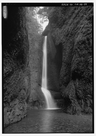
Oneonta Gorge is a scenic gorge located in the Columbia River Gorge area of the American state of Oregon. The U.S. Forest Service has designated it as a botanical area because of the unique aquatic and woodland plants that grow there. Exposed walls of 25-million-year-old basalt are home to a wide variety of ferns, mosses, hepatics, and lichens, many of which grow only in the Columbia River Gorge. Oneonta Gorge with its 50 species of wildflowers, flowering shrubs and trees has been described as "one of the true dramatic chasms in the state." The Oneonta Gorge Creek Bridge is listed on the National Register of Historic Places.

Uvas Canyon County Park is a 1,147-acre (464 ha) natural park located in upper Uvas Canyon on the eastern side of the Santa Cruz Mountains, west of Morgan Hill, California. The park has several small waterfalls, some of which flow perennially, that feed into tributaries confluent with Uvas Creek. The park is part of the Santa Clara County Parks System, and facilitates picnics, hiking and overnight camping. It is one of the few parks in the area that allows dogs in the campgrounds.

Bonita Falls are a set of waterfalls in the San Bernardino National Forest, formed by Bonita Creek, that is said to be 370 or 400 feet in height, but possibly up to 495 feet high because of two undocumented drops in the canyon above. It is the second tallest in the national forest, being surpassed only by 500-foot (150 m) Big Falls. These two waterfalls are reputably the tallest in southern California.

Mill Creek Falls, is a waterfall located in the Rogue River Canyon within the Prospect State Scenic Viewpoint in Jackson County, in the U.S. state of Oregon. The waterfall is located at the south end of Mill Creek as it plunges into the Rogue River over a carved cliff surrounded by walls of petrified volcanic ash consequence of Mount Mazama eruption.
Jordan Creek Falls drops 588 feet (179 m) along Jordan Creek in Skagit County, Washington. The cascade has a run of 250 feet (76 m) and is fed by two large lakes and a large watershed. The falls' elevation is at 3,086 feet (941 m).
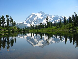
There are four prominent waterfalls in the basin of a short tributary of Sulphide Creek, on the southeast flank of 9,127-foot (2,781m) Mount Shuksan in North Cascades National Park, Washington. Seahpo Peak Falls and Cloudcap Falls, the taller two of the three, are located on separate streams that converge and plunge over Rockflow Canyon Falls. The unnamed outlet stream from these waterfalls flows into Sulphide Creek, which flows into the Baker River. Another waterfall is Jagged Ridge Falls, on a tributary of the unnamed stream.
Otter Falls is a waterfall in King County, Washington; on the southern wall of Mount Anderson. It drops about 1,600 feet (490 m) in all, but due to the relatively moderate pitch of the mountainside, only about 1/3 of the total height can be seen from the ground. The drainage of Otter Creek, which feeds the falls, is fairly small, and consists mostly of granite which does not retain water. Therefore, the waterfall relies entirely on snowmelt to flow and often dries up by July.
Deer Falls is the uppermost waterfall on the North Fork Skykomish River. The falls occur within a short but impressive canyon just above the mouth of Goblin Creek.
Wy'east Falls is a waterfall on a small tributary of Eagle Creek in Hood River County, Oregon, U.S.
Asbestos Falls is a waterfall on Clear Creek in Snohomish County, Washington. It is located just above the mouth of Helena Creek.
The Boulder River is home to 3 waterfalls, one just below its headwaters and the other 2 closer to its mouth. Below are descriptions of all 3:

Eagle Creek is a tributary of the Columbia River in Multnomah and Hood River counties in the U.S. state of Oregon. It cuts through a narrow canyon in its 3,200 feet (980 m) descent to the Columbia River Gorge and is known for its concentration of 13 waterfalls in about 5 miles (8.0 km) distance. Eight major falls are on Eagle Creek and the East Fork Eagle Creek itself, while five are on its tributaries.
There are multiple waterfalls in the basin of the North Fork Cascade River, a river in the North Cascades of Washington that drains to the Cascade River. Many of these are taller than the more famous waterfalls in North America, but do not receive much attention due to their remoteness.
The Paradise River in Washington state, United States, is known for having a total of eight major waterfalls.

The Poesten Kill is a 26.2-mile-long (42.2 km) creek in upstate New York located entirely in Rensselaer County, which flows westerly from its source at Dyken Pond in the town of Berlin to its mouth at the Hudson River in the city of Troy. The Poesten Creek has historically been used as a source of water for the local inhabitants and farmers. during the Industrial Revolution it became even more important as a source of water power, and many mills and factories sprung up along its banks
Wallalute Falls is a large waterfall located on Compass Creek on the north slopes of Mount Hood in the Hood River County, Oregon, at an elevation of 4,879 feet (1,487 m). For many years maps have mislabeled the location of Wallalute Falls locating it on the Eliot Branch of the West Fork Hood River, one canyon over from Compass Creek where it is still labeled on maps today. Historical documentation in Jack Grauer's book A Complete History of Mt Hood, however, provides 1890s-era photos of two waterfalls located in this area, one labeled Wallalute and one labeled "Strawnahans", where only "Strawnahans" Falls is a photographic match to the actual waterfall located on the Eliot Branch visible from the Cloud Cap road at Inspiration Point.
The Koma Kulshan Project is a 13.3 MW run-of-the-river hydroelectric generation facility on the slopes of Mount Baker, a stratovolcano in Washington state's North Cascades. The project commenced commercial operation in October 1990, and is owned by a Covanta Energy–Atlantic Power joint venture. It supplies Puget Sound Energy via a Power Supply Agreement (PSA) contract. Its single turbine is a Pelton wheel supplied by Sulzer Escher Wyss.

The Barberville Falls is a waterfall and nature preserve located in Poestenkill, New York. The fall flows into the Poesten Kill, which is a large creek that flows through Rensselaer County.

