
Oxfordshire is a ceremonial county in South East England. The county is bordered by Northamptonshire and Warwickshire to the north, Buckinghamshire to the east, Berkshire to the south, and Wiltshire and Gloucestershire to the west. The city of Oxford is the largest settlement and county town.

Lechlade is a town at the edge of the Cotswolds in Gloucestershire, England, 55 miles (89 km) south of Birmingham and 68 miles (109 km) west of London. It is the highest point at which the River Thames is navigable, although there is a right of navigation that continues south-west into Cricklade, in the neighbouring county of Wiltshire. The town is named after the River Leach that joins the Thames near the Trout Inn and St. John's Bridge.

Box is a large village and civil parish within the Cotswolds Area of Outstanding Natural Beauty in Wiltshire, England, about 3 miles (5 km) west of Corsham and 5 miles (8 km) northeast of Bath. Box also falls in the easternmost part of the Avon Green Belt. Besides the village of Box, the parish includes the villages of Ashley and Box Hill; Hazelbury manor; and the hamlets of Alcombe, Blue Vein, Chapel Plaister, Ditteridge, Henley, Kingsdown, Middlehill, and Wadswick. To the east the parish includes much of Rudloe, formerly a hamlet but now a housing estate, and the defence establishments and related businesses on the site of the former RAF Rudloe Manor.

Biddestone is a village and former civil parish, now in the parish of Biddestone and Slaughterford, in northwest Wiltshire, England, about 3 miles (5 km) west of Chippenham and 2 miles (3.2 km) north of Corsham. The parish includes the smaller settlement of Slaughterford.

Adlestrop is a village and civil parish in the Cotswolds, 3 miles (5 km) east of Stow-on-the-Wold, Gloucestershire, England, on the county boundary with Oxfordshire. The River Evenlode forms the southwest boundary of the parish. The village is on a stream that flows southwest to join the river.
Luckington is a village and civil parish in the southern Cotswolds, in north-west Wiltshire, England, about 6+1⁄2 miles (10 km) west of Malmesbury. The village is on the B4040 road linking Malmesbury and Chipping Sodbury. The parish is on the county border with Gloucestershire and includes the village of Alderton and the hamlet of Brook End.

Tormarton is a village and civil parish in the South Gloucestershire district, in the ceremonial county of Gloucestershire, England. The village is about half a mile north of the M4 motorway; the A46 road towards Bath passes a similar distance west of the village to join the motorway at junction 18. The parish includes the small village of West Littleton, south of the motorway. The parish population at the 2021 census was 323. The Cotswold Way footpath passes through the village.
Ashton Keynes is a village and civil parish in north Wiltshire, England which borders with Gloucestershire. The village is about 5 miles (8 km) south of Cirencester and 3.5 miles (5.6 km) west of Cricklade. At the 2011 census the population of the parish, which includes the hamlet of North End, was 1,400.

Somerford Keynes is a village and civil parish in the Cotswold district of Gloucestershire, England, close to the River Thames and about 5 miles from its source. It lies on the boundary with Wiltshire, midway between Cirencester, Swindon and Malmesbury. The parish population at the 2011 census was 479, and a 2019 estimate put it at 558. The parish includes the village of Shorncote.

Shipton Moyne is a village and civil parish in the Cotswold district of Gloucestershire, England, approximately 105 miles west of London. Its nearest towns are Tetbury, also in Gloucestershire, and Malmesbury in Wiltshire. The parish population at the 2021 census was 288.

Keevil is a village and civil parish in Wiltshire, England, about 4 miles (6 km) east of the centre of Trowbridge and a similar distance south of Melksham. The village lies on a slope between Great Hinton and Bulkington. Semington Brook forms much of the northeast boundary of the parish.

Kington St Michael is a village and civil parish about 3 miles (4.8 km) north of Chippenham in Wiltshire, England.
Yatton Keynell is a village and civil parish in Wiltshire, England. The village is on the B4039 road near Castle Combe, about 4 miles (6 km) northwest of Chippenham, and about the same distance to the east of the county border with South Gloucestershire.

Miserden is a village and civil parish in Stroud District, Gloucestershire, England, 4 miles north east of Stroud. The parish includes Whiteway Colony and the hamlets of Sudgrove and The Camp. In the 2001 census the parish had a population of 420, increasing to 449 at the 2011 census.
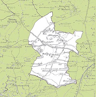
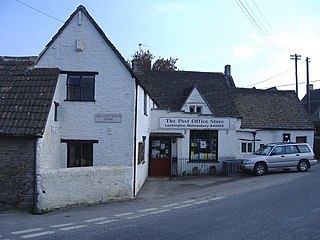
Chippenham Without is a civil parish in Wiltshire, England, created as a separate entity from the parish of Chippenham by the Local Government Act 1894 and largely consisting of farmland to the west of Chippenham, towards Biddestone. Of note within it are the ancient settlements of Allington and Sheldon, the latter with its manor house. The population taken at the 2011 census was 208.
Marston Meysey, pronounced and sometimes also spelt Marston Maisey, is a village and civil parish in Wiltshire, England, lying 3 miles (5 km) northeast of Cricklade on the county boundary with Gloucestershire. The parish includes the hamlet of Marston Hill. Marston Maisey is the spelling for the civil parish, but not for the village on Ordnance Survey maps.

Inglesham is a small village and civil parish in the Borough of Swindon, Wiltshire, England, notable for the Grade-I listed St John the Baptist Church. The village is just off the A361 road about 1 mile (1.6 km) south-west of Lechlade in Gloucestershire. Most of the population lives in the hamlet of Upper Inglesham, which is on the main road about 1.3 miles (2 km) south of the village.

Sopworth is a small village and civil parish in northwest Wiltshire, England, on the county's border with Gloucestershire. The village lies about 1.7 miles (2.7 km) west of Sherston and 6.5 miles (10 km) west of Malmesbury. The parish is within the Cotswolds Area of Outstanding Natural Beauty.

Crudwell is a village and civil parish in north Wiltshire, England. The nearest towns are Malmesbury, about 4 miles (6.4 km) to the south-west, and Cirencester, Gloucestershire 8 miles (13 km) to the north-east. Also to the north-east is Cotswold Airport. Kemble village, about 4 miles (6.4 km) away, has the nearest railway station, with services to London Paddington and Gloucester.

Poulton is a village and civil parish in the English county of Gloucestershire, approximately 24 miles (39 km) to the south-east of Gloucester. It lies in the south of the Cotswolds, an Area of Outstanding Natural Beauty. In the 2001 United Kingdom census, the parish had a population of 398, increasing to 408 at the 2011 census.

