
Bristol Temple Meads is the oldest and largest railway station in Bristol, England. It is located 118 miles 31 chains away from London Paddington. It is an important transport hub for public transport in the city; there are bus services to many parts of the city and surrounding districts, with a ferry to the city centre. Bristol's other major station, Bristol Parkway, is a more recent station on the northern outskirts of the conurbation. It is the busiest station in South West England.

The West Somerset Railway (WSR) is a 22.75-mile (36.6 km) heritage railway line in Somerset, England. The freehold of the line and stations is owned by Somerset Council. The railway is leased to and operated by West Somerset Railway plc, which is supported and minority-owned by the West Somerset Railway Association (WSRA) charitable trust and the West Somerset Railway Heritage Trust (WSRHT). WSR operates services using both heritage steam and diesel trains.

The Bristol Harbour Railway was a standard-gauge industrial railway that served the wharves and docks of Bristol, England. The line, which had a network of approximately 5 mi (8.0 km) of track, connected the Floating Harbour to the GWR mainline at Bristol Temple Meads. Freight could be transported directly by waggons to Paddington Station in London. The railway officially closed in 1964.

The Weston, Clevedon and Portishead Light Railway (WC&PR) was a 14.01-mile (22.55 km) standard gauge light railway in Somerset, England. It was conceived as a tramway in the 1880s, opening between the coastal towns of Weston-super-Mare and Clevedon in 1897 and completed to Portishead in 1907. It closed in 1940.
The Bristol and Gloucester Railway was a railway company opened in 1844 to run services between Bristol and Gloucester. It was built on the 7 ftBrunel gauge, but it was acquired in 1845 by the 4 ft 8+1⁄2 instandard gauge Midland Railway, which also acquired the Birmingham and Gloucester Railway at the same time.

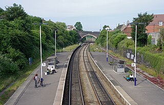
Highbridge and Burnham railway station is situated on the Bristol Temple Meads - Exeter St David's Line in the town of Highbridge, Somerset and also serves the neighbouring town of Burnham-on-Sea. It is 145 miles 25 chains from the zero point at London Paddington via Box. It is unstaffed but managed by Great Western Railway who operate all the regular services.

The Portishead Railway is a branch line railway running from Portishead in North Somerset to the main line immediately west of Bristol, England. It was constructed by the Bristol & Portishead Pier and Railway Company, but it was always operated by its main line neighbour, and was more usually thought of as the Portishead branch or the Portishead railway.
Bristol is a city in south west England, near the Bristol Channel coast, approximately 106 miles (170 km) west of London. Several factors have influenced the development of its transport network. It is a major centre of employment, retail, culture and higher education, has many historic areas, and has a history of maritime industry. The city has a population of 450,000, with a metropolitan area of 650,000, and lies at the centre of the former County of Avon, which includes many dormitory towns, and has a population of one million.

The Bristol and Exeter Railway (B&ER) was an English railway company formed to connect Bristol and Exeter. It was built on the broad gauge and its engineer was Isambard Kingdom Brunel. It opened in stages between 1841 and 1844. It was allied with the Great Western Railway (GWR), which built its main line between London and Bristol, and in time formed part of a through route between London and Cornwall.

Yate railway station serves the town of Yate in South Gloucestershire, in south west England. The station is located on the main Bristol to Birmingham line between Bristol Parkway and Cam & Dursley, and is operated by Great Western Railway.

Bedminster railway station is on the Bristol to Exeter line and serves the districts of Bedminster and Windmill Hill in Bristol, south-west England. It is 0.9 miles (1.4 km) to the west of Bristol Temple Meads, and 119 miles (192 km) from London Paddington. Its three letter station code is BMT. It was opened in 1871 by the Bristol and Exeter Railway, was resited slightly further to the west in 1884 and was rebuilt in 1932. The station, which has three through-lines and two island platforms, but minimal facilities, is managed by Great Western Railway who operates all train services that serve the station, mainly an hourly service between Bristol Parkway and Weston-super-Mare.
Parson Street railway station serves the western end of Bedminster in Bristol, England. It also serves other surrounding suburbs including Bishopsworth, Ashton Vale and Ashton Gate, along with Bristol City FC. It is 2 miles (3.2 km) from Bristol Temple Meads, and 120 miles (193 km) from London Paddington. Its three letter station code is PSN. It was opened in 1927 by the Great Western Railway, and was rebuilt in 1933. The station, which has two through-lines and two platforms, plus one freight line for traffic on the Portishead Branch Line, has minimal facilities. As of 2020, it is managed by Great Western Railway, which is the sixth company to be responsible for the station, and the third franchise since privatisation in 1997. They provide all train services at the station, mainly an hourly service between Bristol Parkway and Weston-super-Mare.
The Wilts, Somerset and Weymouth Railway (WS&WR) was an early railway company in south-western England. It obtained Parliamentary powers in 1845 to build a railway from near Chippenham in Wiltshire, southward to Salisbury and Weymouth in Dorset. It opened the first part of the network but found it impossible to raise further money and sold its line to the Great Western Railway (GWR) in 1850.

The network of railways in Plymouth, Devon, England, was developed by companies affiliated to two competing railways, the Great Western Railway and the London and South Western Railway. At their height two main lines and three branch lines served 28 stations in the Plymouth area, but today just six stations remain in use.

Ashton Gate railway station was a railway station serving the Ashton Gate area of Bristol, England, which included Ashton Gate football ground, the home ground of Bristol City F.C. It was located on the Portishead Railway.

Clifton Bridge railway station is a former railway station in the Bower Ashton district of Bristol, England, near the River Avon. It was opened in 1867 by the Bristol and Portishead Pier and Railway Company as a single platform stop 3.4 miles (5.5 km) along the line from Bristol to Portishead. It was later taken over by the Great Western Railway and had a second platform added.

Pill railway station was a railway station on the Portishead Branch Line, 7.8 miles (12.6 km) west of Bristol Temple Meads, serving the village of Pill in North Somerset, England. The station was opened by the Bristol and Portishead Pier and Railway Company on 18 April 1867. It had two platforms, on either side of a passing loop, with a goods yard and signal box later additions. Services increased until the 1930s, at which point a half-hourly service operated. However the Portishead Branch was recommended for closure by the Beeching report, and the station was closed on 7 September 1964, although the line saw freight traffic until 1981. Regular freight trains through the station began to run again in 2002 when Royal Portbury Dock was connected to the rail network.

The Severn Bridge Railway was a railway company which constructed a railway from Lydney to Sharpness in Gloucestershire, England. It was intended chiefly to give access for minerals in the Forest of Dean to Sharpness Docks, and the company built a long bridge, 1,387 yards (1,268 m) in length, over the River Severn. The line opened in 1879.

The earliest known infrastructure for transport in Somerset is a series of wooden trackways laid across the Somerset Levels, an area of low-lying marshy ground. To the west of this district lies the Bristol Channel, while the other boundaries of the county of Somerset are along chains of hills that were once exploited for their mineral deposits. These natural features have all influenced the evolution of the transport network. Roads and railways either followed the hills, or needed causeways to cross the Levels. Harbours were developed, rivers improved, and linked to sources of traffic by canals. Railways were constructed throughout the area, influenced by the needs of the city of Bristol, which lies just to the north of Somerset, and to link the ports of the far south-west with the rest of England.
The Bristol and Gloucestershire Railway was an early mineral railway, opened in two stages in 1832 and 1834, which connected collieries near Coalpit Heath with Bristol, at the river Avon. Horse traction was used. It was later taken over by the Bristol and Gloucester Railway, and much of the route became part of the main line between Birmingham and Bristol, though that was later by-passed and closed. Part of it now forms the Bristol and Bath Railway Path.


