
Aspen is a home rule municipality that is the county seat and the most populous municipality of Pitkin County, Colorado, United States. The city population was 7,004 at the 2020 United States Census. Aspen is in a remote area of the Rocky Mountains' Sawatch Range and Elk Mountains, along the Roaring Fork River at an elevation just below 8,000 feet (2,400 m) above sea level on the Western Slope, 11 miles (18 km) west of the Continental Divide. Aspen is now a part of the Glenwood Springs, CO Micropolitan Statistical Area.
Scouting in Colorado has a long history, from the 1910s to the present day.

Salida is the statutory city that is the county seat and the most populous municipality of Chaffee County, Colorado, United States. The population was 5,666 at the 2020 census.
The Town of Carbondale is a home rule municipality located in Garfield County, Colorado, United States. The town population was 6,434 at the 2020 United States Census. Carbondale is a part of the Glenwood Springs, CO Micropolitan Statistical Area.

Glenwood Springs is a home rule municipality that is the county seat of Garfield County, Colorado, United States. The city population was 9,963 at the 2020 United States Census. Glenwood Springs is located at the confluence of the Roaring Fork River and the Colorado River, connecting the Roaring Fork Valley and a series of smaller towns on the Colorado River.

Snowmass Village is a home rule municipality in Pitkin County, Colorado, United States. The population was 3,096 at the 2020 census. A popular winter resort location for skiing and snowboarding, the town is well known as the location of the Snowmass ski area, the largest of the four nearby ski areas operated collectively as Aspen/Snowmass. In 2010, the accidental discovery by a bulldozer operator of fossilized elements of a Pleistocene ecosystem in the ice age lake bed at the Ziegler Reservoir put Snowmass Village prominently on the paleontological map of North America.

Colorado Mountain College (CMC) is a public community college with multiple campuses in western Colorado. Founded in 1965, the institution offers numerous associate degrees, seven bachelor's degrees and a variety of career-technical certificates. Approximately 20,000 students take on-campus or online classes every year.

The Western Slope is a colloquial term generally understood to describe the part of the state of Colorado west of the Continental Divide. Bodies of water west of the Divide flow toward the Pacific Ocean; water that falls and flows east of the Divide heads east toward the Gulf of Mexico. The Western Slope encompasses about 33% of the state, but has just 10% of the state's residents. The eastern part of the state, including the San Luis Valley and the Front Range, is the more populous portion of the state.
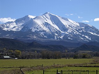
The Roaring Fork Valley is a geographical region in western Colorado in the United States. The Roaring Fork Valley is one of the most affluent regions in Colorado and the U.S. as well as one of the most populous and economically vital areas of the Colorado Western Slope. The Valley is defined by the valley of the Roaring Fork River and its tributaries, including the Crystal and Fryingpan River. It includes the communities of Aspen, Snowmass Village, Basalt, Carbondale, and Glenwood Springs. Mount Sopris and the Roaring Fork River serve as symbols of the Roaring Fork Valley.

The Maroon Bells are two peaks in the Elk Mountains, Maroon Peak and North Maroon Peak, separated by about half a kilometer. The mountains are on the border between Pitkin County and Gunnison County, Colorado, United States, about 19 kilometres (12 mi) southwest of Aspen. Both peaks are fourteeners. Maroon Peak, at 4,317 metres (14,163 ft), is the 27th highest peak in Colorado. North Maroon Peak, at 4,273 metres (14,019 ft), is the 50th highest. The view of the Maroon Bells to the southwest from the Maroon Creek valley is very heavily photographed. The peaks are located in the Maroon Bells–Snowmass Wilderness of White River National Forest. Maroon Bells-Snowmass Wilderness was one of five areas in Colorado designated as wilderness in the original Wilderness Act of 1964. The Wilderness area surrounds the extremely popular Maroon Bells Scenic Area, which is a major access point for Wilderness travel.

Air Academy High School (AAHS) is a public high school in El Paso County, Colorado, United States that serves the northwestern end of Colorado Springs, Colorado, as well as the United States Air Force Academy. Air Academy is a part of Academy School District 20. It is the only high school in the U.S. built on a military academy.

Douglas County School District Re. 1 is a school district that serves Douglas County, Colorado. The district was formed in 1958 by the consolidation of 17 smaller school districts, adding the "Re. 1" to its name to note the district's first reorganization.

The Conejo Valley Unified School District (CVUSD) is a school district in Ventura County, California. The district serves the Conejo Valley area, including the city of Thousand Oaks, the adjacent community of Newbury Park, and the Ventura County portion of Westlake Village.
The Cherry Creek School District 5, also known as Cherry Creek Public Schools, is a school district located in western Arapahoe County, Colorado. The current superintendent is Christopher Smith. Former superintendent Scott Siegfried, Ph.D. announced his retirement on January 22, 2021. It consists of elementary, middle, and high schools. The district headquarters are in Greenwood Village.

Academy School District 20 is a school district located in El Paso County, Colorado. It is in the northern part of Colorado Springs, Colorado and the area surrounding the Air Force Academy.
The St. Vrain Valley School District is the local school district for Longmont, Colorado, United States, and several nearby communities. It is the seventh largest district in the state.

The following outline is provided as an overview of and topical guide to the U.S. state of Colorado:

Independence is an extinct town located in Pitkin County, Colorado, United States. It is located at an elevation of 10,913 feet (3,326 m) 2.2 miles (3.6 km) directly west of Independence Pass. It was the first settlement established in the Roaring Fork Valley, after gold was struck in the vicinity on Independence Day, July 4, 1879, hence its name. Independence was served by three differently named post offices: Farwell from July 14, 1881, until July 3, 1882; Sparkill from February 1, 1882, until October 18, 1887; and Chipeta from April 20, 1899, until October 17, 1899. It has also been known historically as Mammoth City, Mount Hope, and Hunter's Pass.

Edgerton is an extinct town at the confluence of Monument Creek and West Monument Creek eight miles north of present-day Colorado Springs in El Paso County, Colorado, United States. It was across from Black Forest. The Edgerton post office operated from June 16, 1870, until August 28, 1902.
