A caldera is a large cauldron-like hollow that forms shortly after the emptying of a magma chamber/reservoir in a volcanic eruption. When large volumes of magma are erupted over a short time, structural support for the rock above the magma chamber is lost. The ground surface then collapses downward into the emptied or partially emptied magma chamber, leaving a massive depression at the surface. Although sometimes described as a crater, the feature is actually a type of sinkhole, as it is formed through subsidence and collapse rather than an explosion or impact. Only seven caldera-forming collapses are known to have occurred since 1900, most recently at Bárðarbunga volcano, Iceland in 2014.

A volcano is a rupture in the crust of a planetary-mass object, such as Earth, that allows hot lava, volcanic ash, and gases to escape from a magma chamber below the surface.

The Ring of Fire is a major area in the basin of the Pacific Ocean where many earthquakes and volcanic eruptions occur. In a large 40,000 km (25,000 mi) horseshoe shape, it is associated with a nearly continuous series of oceanic trenches, volcanic arcs, and volcanic belts and plate movements. It has 452 volcanoes.
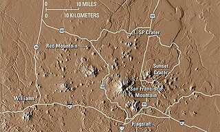
The San Francisco volcanic field is an area of volcanoes in northern Arizona, north of Flagstaff, USA. The field covers 1,800 square miles (4,700 km²) of the southern boundary of the Colorado Plateau. The field contains 600 volcanoes ranging in age from nearly 6 million years old to less than 1,000 years, of which Sunset Crater is the youngest. The highest peak in the field is Humphreys Peak, at Flagstaff's northern perimeter: the peak is Arizona's highest at 12,633 feet and is a part of the San Francisco Peaks, an extinct stratovolcano complex.
A monogenetic volcanic field is a type of volcanic field consisting of a group of small monogenetic volcanoes, each of which erupts only once, as opposed to polygenetic volcanoes, which erupt repeatedly over a period of time. Many monogenetic volcanoes are cinder cones, often with lava flows, such as Parícutin in the Michoacán-Guanajuato volcanic field, which erupted from 1943 to 1952. Some monogenetic volcanoes are small lava shields, such as Rangitoto Island in the Auckland volcanic field. Other monogenetic volcanoes are tuff rings or maars. A monogenetic field typically contains between ten and a hundred volcanoes. The Michoacán-Guanajuato field in Mexico contains more than a thousand volcanoes and is much larger than usual.

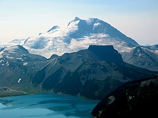
The Auckland volcanic field is an area of monogenetic volcanoes covered by much of the metropolitan area of Auckland, New Zealand's largest city, located in the North Island. The approximately 53 volcanoes in the field have produced a diverse array of maars, tuff rings, scoria cones, and lava flows. No volcano has erupted twice, but eruptions lasted for various periods ranging from a few weeks to several years. The field is fuelled entirely by basaltic magma, unlike the explosive subduction-driven volcanism in the central North Island, such as at Mount Ruapehu and Lake Taupo. The field is currently dormant, but could become active again.

The Nabro Volcano is a stratovolcano in the Southern Red Sea Region of Eritrea. It is located at the south-east end of the Danakil Alps in the Danakil Depression. Before its 2011 eruption, the volcano was widely believed to be extinct.

The Dubbi Volcano is a stratovolcano located in the Southern Red Sea Region of Eritrea. Its peak elevation is 1625 m. There have been four known eruptions. In 1400 lava was determined to have reached the Red Sea while in 1861 ash was thrown over 250 km from the volcano. Two further events were suspected between 1861 and the 20th century.
The Gufa Volcano is a volcanic field located in the Southern Red Sea Region of Eritrea near the border with Djibouti. The peak elevation is 600 m where lava flows are visible. The last eruption of the volcano was inferred to be during the Holocene era.

Raton-Clayton volcanic field is an extinct volcanic field located in the state of New Mexico, United States. Capulin Volcano National Monument is located in the volcanic field. It is thought to have been formed by the Raton hotspot.

Jabal al-Tair Island is a roughly oval volcanic island in Yemen, northwest of the constricted Bab al-Mandab passage at the mouth of the Red Sea, about halfway between mainland Yemen and Eritrea. From 1996 until it erupted in 2007, Yemen maintained two watchtowers and a small military base on the island.

The Wells Gray-Clearwater volcanic field, also called the Clearwater Cone Group, is a potentially active monogenetic volcanic field in east-central British Columbia, Canada, located approximately 130 km (81 mi) north of Kamloops. It is situated in the Cariboo Mountains of the Columbia Mountains and on the Quesnel and Shuswap Highlands. As a monogenetic volcanic field, it is a place with numerous small basaltic volcanoes and extensive lava flows.

Volcanology of Western Canada includes lava flows, lava plateaus, lava domes, cinder cones, stratovolcanoes, shield volcanoes, greenstone belts, submarine volcanoes, calderas, diatremes and maars, along with examples of more less common volcanic forms such as tuyas and subglacial mounds.

The 2011 Nabro eruption was an eruption of the Nabro stratovolcano in the Southern Red Sea Region of Eritrea, which began on 12 June 2011 after a series of earthquakes. The eruption killed seven and possibly a further 31 people and is estimated to be the highest altitude injection of sulfur dioxide (SO2) ever observed by satellite. The Mount Pinatubo eruption 20 years earlier emitted ten times more SO2. The ash cloud from the eruption reached altitudes which disrupted airline traffic in the region. Until the eruption began, the volcano had no records of historical eruptions.

Sork Ale is a sicilic stratovolcano located in the Danakil Horst at the southern end of the Danakil Alps near the Ethiopia/Eritrea border. It makes up part of the Bidu volcanic complex.
The Danakil Alps are a highland region in Ethiopia and Eritrea with peaks over 1000 metres in height and a width varying between 40 and 70 kilometres. The alps lie to the east of the Danakil Depression and separate it from the southern Red Sea. A rift escarpment facing the Red Sea forms the eastern boundary of the range.