
Milwaukee is the most populous city in the U.S. state of Wisconsin and the county seat of Milwaukee County. With a population of 577,222 at the 2020 census, Milwaukee is the 31st-most populous city in the United States and the fifth-most populous city in the Midwest. It is the central city of the Milwaukee metropolitan area, the 40th-most populous metro area in the U.S. with 1.57 million residents.

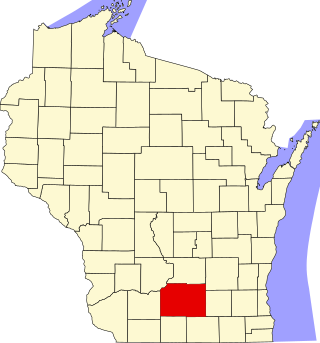
Brown County is a county in the U.S. state of Wisconsin. As of the 2020 census, the population was 268,740, making it the fourth-most populous county in Wisconsin. The county seat is Green Bay. Brown County is part of the Green Bay, WI Metropolitan Statistical Area.

De Pere is a city in Brown County, Wisconsin, United States. The population was 25,410 at the 2020 census. It is part of the Green Bay metropolitan area.
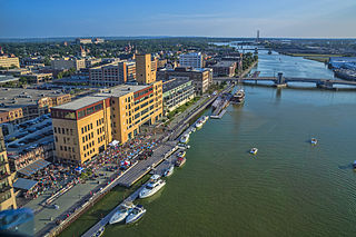
Green Bay is a city in and the county seat of Brown County, Wisconsin, United States. It is located at the head of Green Bay, a sub-basin of Lake Michigan at the mouth of the Fox River. As of the 2020 census, the city had a population of 107,395, making it the third-most populous city in Wisconsin, after Milwaukee and Madison, and the third-most populous city on Lake Michigan, after Chicago and Milwaukee.

Aztalan State Park is a Wisconsin state park in the Town of Aztalan, Jefferson County. Established in 1952, it was designated a National Historic Landmark in 1964 and added to the National Register of Historic Places in 1966. The park covers 172 acres (70 ha) along the Crawfish River.

Prairie du Chien is a city in and the county seat of Crawford County, Wisconsin, United States. The population was 5,506 at the 2020 census. Often called Wisconsin's second-oldest city, Prairie du Chien was established as a European settlement by French voyageurs in the late 17th century. Its settlement date of June 17, 1673, makes it the fourth colonial settlement by European settlers in the Midwestern United States, after Green Bay, Wisconsin, Sault Ste. Marie, Michigan, and St. Ignace, Michigan. The city has many sites showing its rich history in the region.

The Fox River is a river in eastern Wisconsin in the Great Lakes region of the United States. It is the principal tributary of the Green Bay, and via the bay, the largest tributary of Lake Michigan. The city of Green Bay, one of the first European settlements in the interior of North America, is on the river at its mouth on the Green Bay.
The history of Wisconsin includes the story of the people who have lived in Wisconsin since it became a state of the U.S., but also that of the Native American tribes who made their homeland in Wisconsin, the French and British colonists who were the first Europeans to live there, and the American settlers who lived in Wisconsin when it was a territory.

Fort Winnebago was a 19th-century fortification of the United States Army located on a hill overlooking the eastern end of the portage between the Fox and Wisconsin Rivers east of present-day Portage, Wisconsin. It was the middle one of three fortifications along the Fox-Wisconsin Waterway that also included Fort Howard in Green Bay, Wisconsin and Fort Crawford in Prairie du Chien, Wisconsin. Fort Winnebago was constructed in 1828 as part of an effort to maintain peace between white settlers and the region's Native American tribes following the Winnebago War of 1827. The fort's location was chosen not only because of its proximity to the site of Red Bird's surrender in the Winnebago War, but also because of the strategic importance of the portage on the Fox-Wisconsin Waterway, a heavily traveled connection between the Great Lakes and the Mississippi River. Fort Winnebago's location near the portage allowed it to regulate transportation between the lakes and the Mississippi.
This is a list of the National Register of Historic Places listings in Dane County, Wisconsin. It aims to provide a comprehensive listing of buildings, sites, structures, districts, and objects in Dane County, Wisconsin listed on the National Register of Historic Places.

Glenwood is an unincorporated community in Lane County, Oregon, United States. It is located between the University of Oregon in Eugene and downtown Springfield on Franklin Boulevard, along the former route of the Pacific Highway, now Oregon Route 99. It is a mixed-use industrial and residential area. The unincorporated character of the area has tended to attract "experimental and individualistic" inhabitants. For decades, Glenwood, which has been seen as a blighted area, has been the subject of redevelopment projects and proposals, including a riverfront redevelopment project.

The Mines of Spain State Recreation Area and E. B. Lyons Nature Center is a state park in Dubuque County, Iowa, United States. It is near Dubuque, the eleventh-largest city in the state. The park features picnic areas, 15 miles (24 km) of walking/hiking trails, 4 miles (6.4 km) of ski trails, and the Betty Hauptli Bird and Butterfly Garden. It also includes archaeological sites of national importance as an early lead mining and smelting venture led by French explorer Julien Dubuque, as well as Dubuque's gravesite. These sites were collectively designated a National Historic Landmark District as Julien Dubuque's Mines.

This is a list of the National Register of Historic Places listings in Brown County, Wisconsin. It is intended to provide a comprehensive listing of entries in the National Register of Historic Places that are located in Brown County, Wisconsin. The locations of National Register properties for which the latitude and longitude coordinates are included below may be seen in a map.
Nils Otto Tank was a Norwegian born, Moravian Church missionary and teacher. He was a pioneer settler in Wisconsin.

Tank Cottage is located within Heritage Hill State Historical Park in Green Bay, Wisconsin. It was added to the National Register of Historic Places in 1970 and may be the oldest building in Wisconsin.

The Prospect Park Second Plat Historic District is a nationally recognized historic district located in the north-central section of Des Moines, Iowa, United States. The residential area contained middle to upper class housing that was developed in the late 19th and early 20th centuries in the suburb of North Des Moines. It has been listed on the National Register of Historic Places since 1998. It is part of the Towards a Greater Des Moines MPS.

Daniel Whitney was an early entrepreneur in territorial Wisconsin, whose businesses were responsible for much of the early development of that state in the period between the War of 1812 and statehood. He was the first "Yankee" to settle in Green Bay. He was the first to start many of the type of business ventures that the state became known for, such as the first lead shot tower and the first saw mill on the Wisconsin River. He was the private founder of the town of Navarino, a direct forerunner to the municipality of Green Bay. He died in 1862 in the home he lived in for over 30 years in Green Bay.

The Freimann Hotel Building (1896) is one of Green Bay's oldest continuing commercial establishments. It is located along the Fox River State Recreational Trail. The building is listed in the Wisconsin Historical Society Register. it is one of only a few remaining 19th century buildings in downtown Green Bay.

Joannes Brothers Company was a wholesaler and retailer of grocery products based in Green Bay, Wisconsin that served the Upper Midwest for over 80 years. The company began as a small retail operation in 1872, growing into an interstate distributor by the turn of the century. The rise of Joannes Brothers was closely linked with the growth of Green Bay and the industrialization of the Great Lakes region, initiating some of the first business transactions that established Green Bay as a regular market. It was acquired by Minnesota-based SuperValu in 1955. A separate venture, initially operating under the same name, was established by an original Joannes Brothers Company founder in Los Angeles in 1905. The operation was acquired by McCormick & Company in 1953.


